SEVERE STORMS AND FLOODING THREATEN MIDDLE TENNESSEE

The National Weather Service is warning of a multi-day severe weather and flooding threat across Middle Tennessee through the weekend. Beginning late Wednesday, multiple rounds of showers and thunderstorms will bring a sharp gradient in rainfall totals across the region, with northwest portions facing the highest threat. Rainfall amounts of 6 to 8 inches or more are likely in those areas, increasing the risk of significant flooding along rivers and creeks. Flooding impacts may persist into next week even after the rain subsides on Sunday.
On Wednesday, a Moderate Risk (Level 4 out of 5) of severe weather has been issued for northwestern Middle Tennessee, including areas like Clarksville, Waverly, and Jackson. The primary threats include damaging winds up to 70 mph, large hail up to 2 inches in diameter, and the potential for strong tornadoes. A Slight to Enhanced Risk extends across much of the remainder of Middle Tennessee.
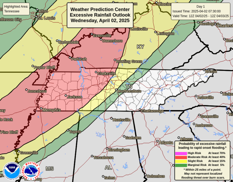
Excessive rainfall outlooks from the Weather Prediction Center indicate a Moderate Risk (at least 40% chance) of flash flooding across west and northwest Tennessee on Wednesday, with a High Risk (at least 70%) in parts of western Tennessee and southeast Missouri on Thursday. These areas are expected to experience multiple rounds of heavy rain that could lead to rapid onset flooding.
Wind Advisories are also in effect for the Cumberland Plateau and East Tennessee Mountains, where sustained winds of 15 to 30 mph with gusts up to 50 mph are expected through Thursday morning. Non-thunderstorm wind gusts across Middle Tennessee may reach up to 45 mph, leading to possible downed trees, branches, and power outages.
Thursday brings continued severe weather potential, with a Slight Risk (Level 2) of severe storms across a large portion of Middle Tennessee. The primary threats include damaging winds, large hail, isolated tornadoes, and heavy rainfall.
Residents are urged to stay weather-aware, secure outdoor items, and have multiple ways to receive warning information as this dynamic and dangerous weather pattern unfolds.
Hear continuing weather updates on 105.7 The Hog, Spirit 101.9, 94.1 The Vibe (1410 AM), 98.9 The Wolf, and 93.3 The Ranch (580 AM).