
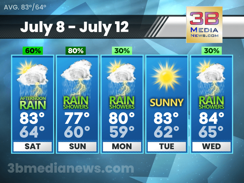
SATURDAY’S 5 DAY FORECAST
Hazardous Weather Outlook: Isolated severe thunderstorms capable of damaging winds and localized flash flooding will be possible Saturday evening, but with better chances on Sunday.
Saturday: Showers and thunderstorms likely, mainly after 1pm. Increasing clouds, with a high near 83. Calm wind becoming west around 5 mph in the morning. Chance of precipitation is 60%. New rainfall amounts of less than a tenth of an inch, except higher amounts possible in thunderstorms.
Saturday Night: Showers and thunderstorms likely before 10pm, then showers likely and possibly a thunderstorm after 10pm. Mostly cloudy, with a low around 64. West wind around 5 mph. Chance of precipitation is 70%.
Sunday: Showers and possibly a thunderstorm. High near 77. West wind 5 to 10 mph. Chance of precipitation is 80%.
Sunday Night: A chance of showers and thunderstorms. Mostly cloudy, with a low around 60. West northwest wind 5 to 10 mph. Chance of precipitation is 30%.
Monday: A chance of showers, with thunderstorms also possible after 1pm. Mostly sunny, with a high near 80. North wind 5 to 10 mph. Chance of precipitation is 30%.
Monday Night: Mostly clear, with a low around 59. North wind 5 to 10 mph.
Tuesday: Sunny, with a high near 83. North northeast wind around 5 mph becoming west in the afternoon.
Tuesday Night: Mostly clear, with a low around 62.
Wednesday: A 30 percent chance of showers and thunderstorms. Sunny, with a high near 84.
Wednesday Night: A 30 percent chance of showers and thunderstorms. Partly cloudy, with a low around 65.
Source: National Weather Service Weather Forecast Offices in Nashville and Morristown.
Forecaster Johnny Caudle has the latest weather forecast every hour on 105.7 The Hog, 94.1 The Vibe, Spirit 101.9, 98.9 The Wolf, and 93.3 The Ranch. Connect with Forecaster Johnny Caudle on social media. Follow him on Facebook, Twitter, and Instagram. Send email to [email protected].