
WEEKEND WEATHER FORECAST: THUNDERSTORMS AND SHOWERS LIKELY, CLEARING BY MIDWEEK
Hazardous Weather Outlook: Isolated to scattered showers and storms are expected this morning, activity will be more isolated this afternoon and evening. A few storms may be strong, with gusty winds and small hail. Heavy downpours may cause localized minor flooding. There will be multiple rounds of showers and thunderstorms moving through during the weekend and into Monday. Some of these storms may become strong to severe at times, with strong gusty winds and hail the primary threats. There may be a period with a low tornado threat as well sometime in the Sunday into Monday time frame. In addition, repeated or prolonged periods of heavy rainfall may produce localized flooding in a few locations.
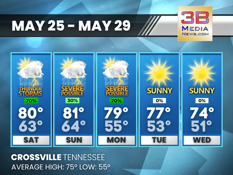
Saturday: Showers and thunderstorms likely, mainly before 1pm. Partly sunny, with a high near 80. South southwest wind around 5 mph becoming west in the afternoon. Chance of precipitation is 70%. New rainfall amounts between a tenth and quarter of an inch, except higher amounts possible in thunderstorms.
Saturday Night: A 30 percent chance of showers and thunderstorms, mainly before 9pm. Partly cloudy, with a low around 63. Calm wind.
Sunday: A 30 percent chance of showers and thunderstorms, mainly after 3pm. Partly sunny, with a high near 81. South southwest wind 5 to 10 mph, with gusts as high as 20 mph.
Sunday Night: A chance of showers and thunderstorms, then showers and possibly a thunderstorm after 1am. Some of the storms could produce heavy rainfall. Low around 64. South southwest wind 5 to 10 mph, with gusts as high as 20 mph. Chance of precipitation is 80%.
Memorial Day: Showers likely and possibly a thunderstorm before 1pm, then showers and thunderstorms likely between 1pm and 4pm, then showers likely and possibly a thunderstorm after 4pm. Mostly sunny, with a high near 79. Southwest wind around 10 mph, with gusts as high as 20 mph. Chance of precipitation is 70%.
Monday Night: A chance of thunderstorms before 7pm. Mostly clear, with a low around 55. West northwest wind around 5 mph becoming calm in the evening. Chance of precipitation is 30%.
Tuesday: Sunny, with a high near 77. Light west wind becoming west northwest 5 to 10 mph in the morning. Winds could gust as high as 20 mph.
Tuesday Night: Mostly clear, with a low around 53. West northwest wind around 5 mph becoming calm in the evening.
Wednesday: Sunny, with a high near 74.
Wednesday Night: Partly cloudy, with a low around 51.
Almanac for Crossville, Tennessee for May 25, 2024:
- Normal High Temperature: 75
- Normal Low Temperature: 55
- Record High Temperature: 86 in 2019
- Record Low Temperature: 37 in 1979
- Sunrise: 5:28 AM CDT
- Sunset: 7:47 PM CDT
- Summer Equinox: Thursday, June 20 2024 at 3:50 PM CDT
- Next Full Moon: Friday, June 21, 2024 at 8:08 PM CDT (Strawberry Moon)
Weather information is provided by the National Weather Service in Nashville and Morristown. Hear the latest forecast on 105.7 The Hog, 94.1 The Vibe (1410 AM), Spirit 101.9, 98.9 The Wolf, and 93.3 The Ranch (580 AM). Get connected with Weathercaster Johnny Caudle on social media. Follow him on Facebook, X, Instagram, and Threads. Click here to send him an email.