FLOOD WATCH ISSUED FOR MIDDLE TENNESSEE
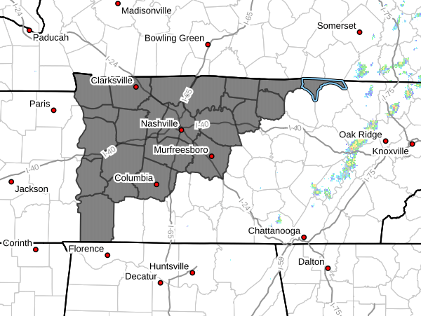
The National Weather Service in Nashville has issued a Flood Watch for portions of Middle Tennessee, including Pickett County, beginning Wednesday evening and continuing through Sunday morning.
Forecasters say several rounds of showers and thunderstorms are expected during this period, producing locally heavy rainfall over already saturated ground. According to the National Weather Service, several inches of rain are possible, particularly across northwest Middle Tennessee.
Confidence has increased in the potential for flooding and flash flooding, especially in areas that receive the most rainfall. This is expected to be a multiple-day flooding event, with possible rises on streams, creeks, and rivers continuing through the weekend.
Flood Watch Information:
-
WHAT: Flooding caused by excessive rainfall is possible.
-
WHERE: A portion of Middle Tennessee, including Pickett County.
-
WHEN: From Wednesday evening through Sunday morning.
-
IMPACTS: Excessive runoff may result in flooding of rivers, creeks, streams, and other low-lying and flood-prone locations. Creeks and streams may rise out of their banks.
Precautionary/Preparedness Actions:
Monitor later forecasts and be alert for possible Flood Warnings. Those living in flood-prone areas should be ready to take action if flooding develops.
Weather updates can be heard on:
-
105.7 The Hog
-
Spirit 101.9
-
94.1 The Vibe / 1410 AM
-
98.9 The Wolf
-
93.3 The Ranch / 580 AM