NEW SEVERE THUNDERSTORM WARNING FOR PICKETT, FENTRESS
BULLETIN – IMMEDIATE BROADCAST REQUESTED
Severe Thunderstorm Warning
National Weather Service Nashville TN
611 AM CDT Thu Apr 3 2025
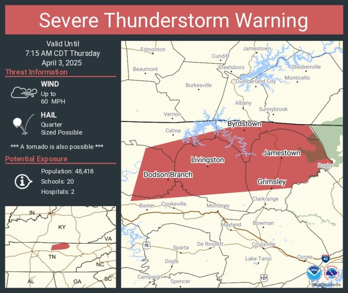
The National Weather Service in Nashville has issued a Severe Thunderstorm Warning for…Overton County in Middle Tennessee…Pickett County in Middle Tennessee…Eastern Jackson County in Middle Tennessee…Southeastern Clay County in Middle Tennessee…Northwestern Putnam County in Middle Tennessee…Fentress County in Middle Tennessee…until 715 AM CDT.
At 610 AM CDT, a severe thunderstorm was located 7 miles east of Gainesboro, moving east at 45 mph.
HAZARD…60 mph wind gusts and quarter size hail.
SOURCE…Radar indicated.
IMPACT…Hail damage to vehicles is expected. Expect wind damage to roofs, siding, and trees.
Locations impacted include…Grimsley, Allardt, Jamestown, Byrdstown, Gainesboro, Livingston, Crawford, Rickman, Pall Mall, Pickett State Park, Cummins Falls State Park, and Standing Stone State Park.
PRECAUTIONARY/PREPAREDNESS ACTIONS…
Remain alert for a possible tornado! Tornadoes can develop quickly from severe thunderstorms. If you spot a tornado go at once into the basement or small central room in a sturdy structure.
For your protection move to an interior room on the lowest floor of a building.
A Tornado Watch remains in effect until 800 AM CDT for Middle Tennessee.
TORNADO…POSSIBLE
HAIL THREAT…RADAR INDICATED
MAX HAIL SIZE…1.00 IN
WIND THREAT…RADAR INDICATED
MAX WIND GUST…60 MPH