
STRONG STORMS POSSIBLE TONIGHT WITH HEAVY RAINFALL
Clouds and mild air linger today, but tonight brings a high chance of severe thunderstorms before clearing out for a sunny Saturday.
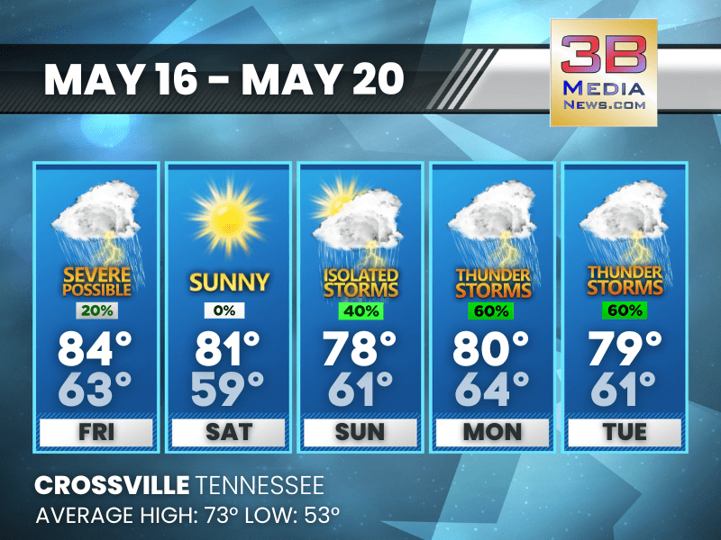
Today: A slight chance of showers and thunderstorms before 3pm, then a slight chance of showers and thunderstorms after 4pm. Mostly cloudy, with a high near 84. South southwest wind 5 to 10 mph, with gusts as high as 25 mph. Chance of precipitation is 20%.
Tonight: Showers and thunderstorms, mainly before 3am. Some of the storms could be severe and produce heavy rainfall. Low around 63. West southwest wind around 10 mph, with gusts as high as 25 mph. Chance of precipitation is 90%. New rainfall amounts between a half and three quarters of an inch possible.
Saturday: Sunny, with a high near 81. West southwest wind 10 to 15 mph, with gusts as high as 25 mph.
Saturday Night: Partly cloudy, with a low around 59. West wind around 5 mph becoming calm in the evening.
Sunday: A chance of showers before 10am, then a chance of showers and thunderstorms between 10am and 1pm, then a chance of showers after 1pm. Partly sunny, with a high near 78. Calm wind becoming west around 5 mph in the afternoon. Chance of precipitation is 40%.
Sunday Night: A slight chance of showers and thunderstorms before 10pm, then a slight chance of showers between 10pm and 1am, then a chance of showers and thunderstorms after 1am. Mostly cloudy, with a low around 61. Calm wind. Chance of precipitation is 30%.
Monday: Showers likely and possibly a thunderstorm. Mostly cloudy, with a high near 80. Calm wind becoming south southwest around 5 mph in the morning. Chance of precipitation is 60%.
Monday Night: A 20 percent chance of showers and thunderstorms after 1am. Mostly cloudy, with a low around 64. South southwest wind around 5 mph becoming calm.
Tuesday: A chance of showers and thunderstorms, then showers likely and possibly a thunderstorm after 1pm. Mostly cloudy, with a high near 79. Southwest wind 5 to 10 mph, with gusts as high as 20 mph. Chance of precipitation is 60%.
Tuesday Night: Showers likely and possibly a thunderstorm. Mostly cloudy, with a low around 61. Chance of precipitation is 70%.
Almanac for Crossville, Tennessee for May 16, 2025:
- Normal High Temperature: 73
- Normal Low Temperature: 53
- Record High Temperature: 88 in 1962
- Record Low Temperature: 33 in 1997
- Sunrise: 5:34 AM CDT
- Sunset: 7:40 PM CDT
- Next Full Moon: Friday, June 11, 2025 at 2:44 AM CDT (known as the Strawberry Moon)
- Summer Solstice: Friday, June 20, 2025 at 9:42 PM CDT
Weather information is provided by the National Weather Service in Nashville and Morristown. Hear the latest forecast on 105.7 The Hog, 94.1 The Vibe (1410 AM), Spirit 101.9, 98.9 The Wolf, and 93.3 The Ranch (580 AM). Get connected with Weathercaster Johnny Caudle on social media. Follow him on Facebook, X, Instagram, Bluesky, and Threads. Click here to send him an email.