May 16, 2025 in Weather

SEVERE THUNDERSTORM WATCH IN EFFECT FOR ANDERSON AND MORGAN COUNTIES

A dramatic lightning storm illuminates the night sky over a mountainous landscape. Bold red and white text reads "SEVERE THUNDERSTORM WATCH" on the right side. On the left side, the 3B Media News logo is displayed with the text "3B Media News.com" in red, blue, and black on a gold and silver gradient background.
A Severe Thunderstorm Watch has been issued. Stay weather-aware and be prepared to take action if warnings are issued. Updates on 3BMediaNews.com and your local 3B Media radio stations.

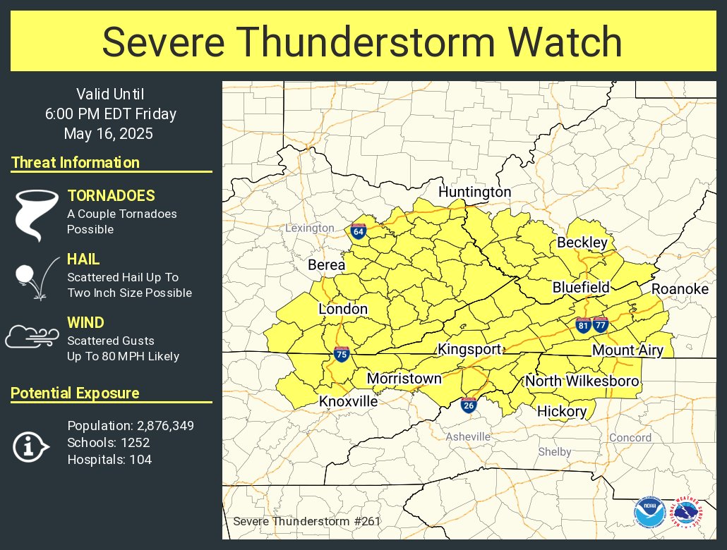
The National Weather Service has issued a Severe Thunderstorm Watch in effect until 6:00 PM EDT Friday, May 16, 2025. The watch includes Anderson and Morgan counties within the 3B Media News coverage area. Storms developing this afternoon may produce scattered hail up to two inches in diameter, damaging wind gusts up to 80 miles per hour, and frequent lightning. A couple of tornadoes are also possible within the watch area. Residents are encouraged to remain alert and have multiple ways to receive warnings as storms move through the region. Hear weather updates on 105.7 The Hog, Spirit 101.9, 94.1 The Vibe (1410 AM), 98.9 The Wolf, and 93.3 The Ranch (580 AM).

Alt Text: A National Weather Service graphic titled "Severe Thunderstorm Watch" shows a highlighted yellow area indicating the watch zone, which includes parts of Kentucky, Tennessee, Virginia, and North Carolina. The watch is valid until 6:00 PM EDT on Friday, May 16, 2025. Threats include possible tornadoes, scattered hail up to two inches, and wind gusts up to 80 MPH. Affected cities include Knoxville, Morristown, Kingsport, London, Berea, Bluefield, Beckley, North Wilkesboro, and Mount Airy. The potential exposure includes over 2.8 million people, 1,252 schools, and 104 hospitals. Icons for tornadoes, hail, and wind are shown on the left.
A Severe Thunderstorm Watch is in effect until 6:00 PM EDT Friday for parts of Tennessee, Kentucky, Virginia, and North Carolina. Damaging winds up to 80 MPH, large hail, and a couple of tornadoes are possible. Stay alert and be ready to act quickly if warnings are issued.


CONTACT INFORMATION

3B Media
105.7 The HOG / Spirit 101.9/ 93.3 The Ranch
94.1 The VIBE / 98.9 The WOLF
37 South Drive
Crossville, TN 38555

Phone: 931-484-1057
Fax: 931-707-0580