
WARM AND MOSTLY SUNNY WEEKEND AHEAD, SHOWERS RETURN MIDWEEK
Fog clears early Saturday before sunshine dominates the weekend. Rain chances return Tuesday night into Wednesday.
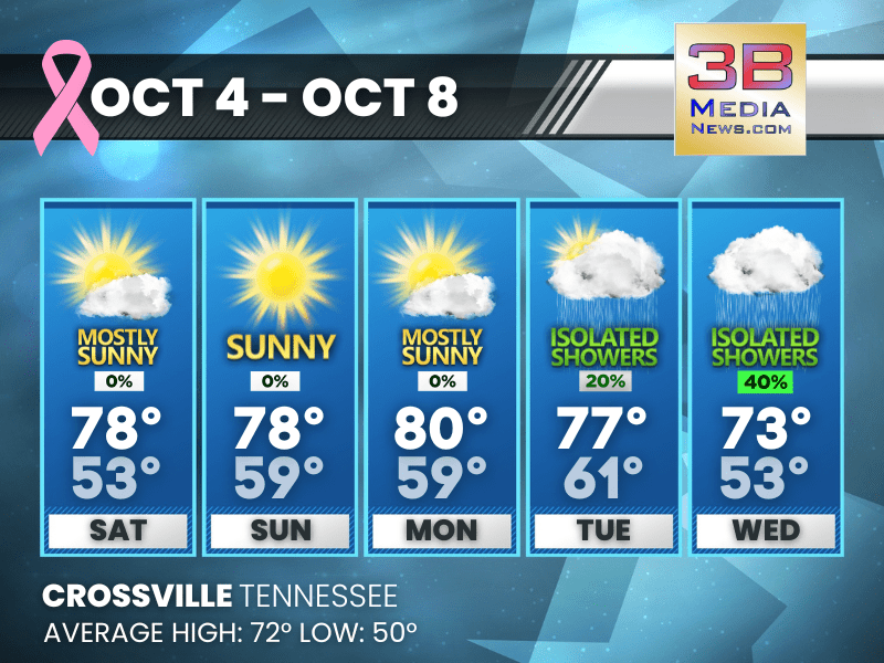
Saturday: Areas of fog before 8am. Otherwise, mostly sunny, with a high near 78. Calm wind becoming east around 5 mph in the afternoon.
Saturday Night: Mostly clear, with a low around 53. Calm wind.
Sunday: Sunny, with a high near 78. Calm wind becoming southeast around 5 mph in the morning.
Sunday Night: Partly cloudy, with a low around 59. Calm wind becoming southeast around 5 mph.
Monday: Mostly sunny, with a high near 80. East southeast wind around 5 mph.
Monday Night: Partly cloudy, with a low around 59. Calm wind becoming south southeast around 5 mph.
Tuesday: A 20 percent chance of showers. Mostly sunny, with a high near 77. South wind around 5 mph.
Tuesday Night: A 40 percent chance of showers, mainly after 1am. Mostly cloudy, with a low around 61.
Wednesday: A 40 percent chance of showers and thunderstorms. Mostly cloudy, with a high near 73.
Wednesday Night: Mostly cloudy, with a low around 53.
Almanac for Crossville, Tennessee for October 4
- Normal High Temperature: 72
- Normal Low Temperature: 50
- Record High Temperature: 86 in 1954
- Record Low Temperature: 28 in 1974
- Record High Rainfall: 1.99 in 1990
- Sunrise: 6:38 AM CDT
- Sunset: 6:19 PM CDT
- Next Full Moon: Monday, October 6, 2025 at 10:48 PM CDT (known as the Harvest Moon; this full moon will also be a supermoon)
- Daylight Saving Time Ends: Sunday, November 2, 2025 at 2:00 AM ET
- Winter Solstice: Sunday, December 21, 2025 at 9:03 AM CST
Weather information is provided by the National Weather Service in Nashville and Morristown. You can hear the latest forecast on 105.7 The Hog, 94.1 The Vibe (1410 AM), Spirit 101.9, 98.9 The Wolf, and 93.3 The Ranch (580 AM). Stay connected with Weathercaster Johnny Caudle on social media by following him on Facebook, X, Instagram, Bluesky, and Threads. You can also click here to send him an email.