
SUNNY STRETCH AHEAD WITH COOL NIGHTS
Clouds break Wednesday with highs near 70, leading into several days of sunshine and cool nights in the mid-40s.
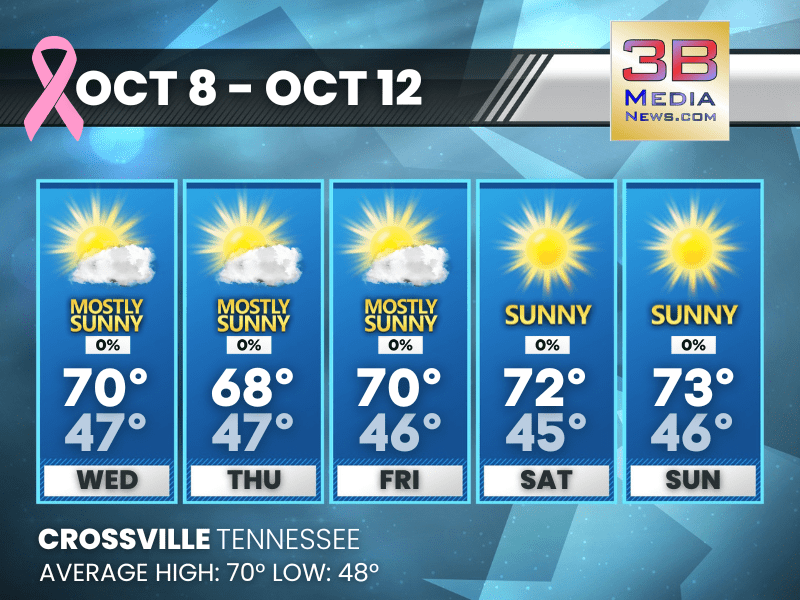
Wednesday: Cloudy, then gradually becoming mostly sunny, with a high near 70. North northeast wind 5 to 10 mph, with gusts as high as 20 mph.
Wednesday Night: Mostly clear, with a low around 47. Northeast wind 5 to 10 mph, with gusts as high as 20 mph.
Thursday: Mostly sunny, with a high near 68. Northeast wind around 5 mph.
Thursday Night: Patchy fog after midnight. Otherwise, partly cloudy, with a low around 47. Northeast wind around 5 mph becoming calm.
Friday: Mostly sunny, with a high near 70. Calm wind becoming north northeast around 5 mph.
Friday Night: Mostly clear, with a low around 46. Calm wind.
Saturday: Sunny, with a high near 72. Calm wind becoming north northeast around 5 mph in the afternoon.
Saturday Night: Mostly clear, with a low around 45.
Sunday: Sunny, with a high near 73.
Sunday Night: Mostly clear, with a low around 46.
Almanac for Crossville, Tennessee for October 8
- Normal High Temperature: 70
- Normal Low Temperature: 48
- Record High Temperature: 84 in 2007
- Record Low Temperature: 28 in 2000
- Record High Rainfall: 3.74 in 1977
- Sunrise: 6:41 AM CDT
- Sunset: 6:14 PM CDT
- Daylight Saving Time Ends: Sunday, November 2, 2025 at 2:00 AM EST
- Next Full Moon: Wednesday, November 5, 2025 at 7:19 AM CST (known as the Beaver Moon; this full moon will also be a supermoon)
- Winter Solstice: Sunday, December 21, 2025 at 9:03 AM CST
Weather information is provided by the National Weather Service in Nashville and Morristown. You can hear the latest forecast on 105.7 The Hog, 94.1 The Vibe (1410 AM), Spirit 101.9, 98.9 The Wolf, and 93.3 The Ranch (580 AM). Stay connected with Weathercaster Johnny Caudle on social media by following him on Facebook, X, Instagram, Bluesky, and Threads. You can also click here to send him an email.