
MILD TODAY, THEN A COLD AND BLUSTERY TURN SUNDAY INTO MONDAY
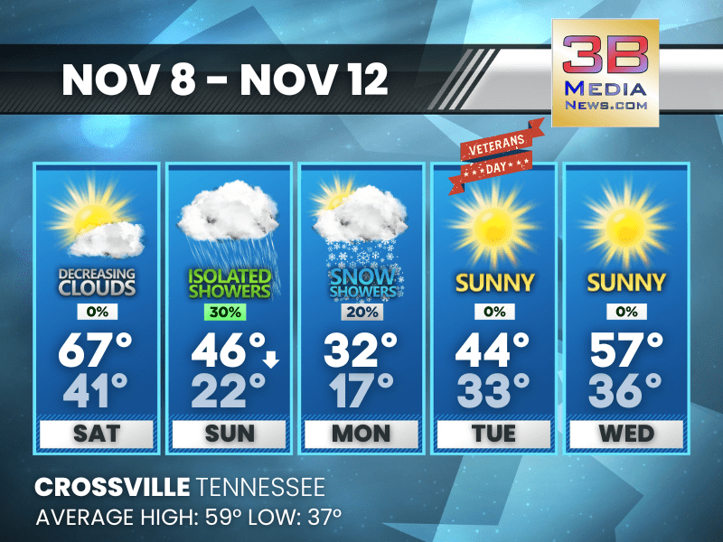
Fog early gives way to sunshine and highs in the upper 60s today, but showers late tonight will usher in sharply colder air, gusty winds, and a chance of snow showers Sunday night into Monday.
Today: Areas of fog before 8am. Otherwise, mostly cloudy, then gradually becoming sunny, with a high near 67. Calm wind becoming southwest around 5 mph.
Tonight: A 30 percent chance of showers, mainly between 2am and 4am. Patchy fog between 8pm and 9pm. Otherwise, increasing clouds, with a low around 41. Light west southwest wind becoming west 5 to 10 mph after midnight. Winds could gust as high as 20 mph.
Sunday: A 30 percent chance of showers, mainly between noon and 5pm. Cloudy, with a temperature rising to near 46 by 9am, then falling to around 37 during the remainder of the day. West northwest wind 10 to 15 mph, with gusts as high as 25 mph.
Sunday Night: A chance of rain and snow showers before 8pm, then a chance of snow showers. Mostly cloudy, with a low around 22. Northwest wind 10 to 15 mph, with gusts as high as 25 mph. Chance of precipitation is 40%.
Monday: A 20 percent chance of snow showers. Partly sunny, with a high near 32. West northwest wind 10 to 15 mph, with gusts as high as 25 mph.
Monday Night: Mostly clear, with a low around 17. West northwest wind 5 to 10 mph, with gusts as high as 20 mph.
Veterans Day: Sunny, with a high near 44. Southwest wind 5 to 10 mph, with gusts as high as 20 mph.
Tuesday Night: Mostly clear, with a low around 33. Southwest wind around 10 mph, with gusts as high as 25 mph.
Wednesday: Sunny, with a high near 57. West southwest wind 5 to 15 mph, with gusts as high as 25 mph.
Wednesday Night: Mostly clear, with a low around 36.
Almanac for Crossville, Tennessee for November 8
- Normal High Temperature: 59
- Normal Low Temperature: 37
- Record High Temperature: 77 in 2022
- Record Low Temperature: 18 in 1959
- Record High Rainfall: 1.17 in 2000
- Record Snowfall: Trace in 1996
- Sunrise: 6:10 AM CST
- Sunset: 4:38 PM CST
- Next Full Moon: Thursday, December 4, 2025 at 5:14 PM CST (known as the Cold Moon; this full moon will also be a supermoon)
- Winter Solstice: Sunday, December 21, 2025 at 9:03 AM CST
- Daylight Saving Time Begins: Sunday, March 8, 2026 at 2:00 AM EDT
Weather information is provided by the National Weather Service in Nashville and Morristown. You can hear the latest forecast on 105.7 The Hog, 94.1 The Vibe (1410 AM), Spirit 101.9, 98.9 The Wolf, and 93.3 The Ranch (580 AM). Stay connected with Weathercaster Johnny Caudle on social media by following him on Facebook, X, Instagram, Bluesky, and Threads. You can also click here to send him an email.