
SOAKED LATE WEEK: THUNDERSTORMS ROLL THROUGH BEFORE A CALMER WEEKEND
Rain and thunderstorms dominate Thursday through Friday night before conditions gradually dry out and cooler, calmer weather settles in for the weekend.
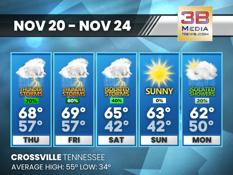
Thursday: Showers likely and possibly a thunderstorm, mainly after 3pm. Areas of fog before 10am, then patchy fog after 5pm. Otherwise, cloudy, with a high near 68. Calm wind. Chance of precipitation is 70%. New rainfall amounts between a quarter and half of an inch possible.
Thursday Night: Showers and thunderstorms, mainly before 4am. Patchy fog before 8pm. Low around 57. Calm wind becoming south around 5 mph. Chance of precipitation is 90%. New rainfall amounts between a quarter and half of an inch possible.
Friday: Showers and thunderstorms likely before 2pm, then showers between 2pm and 3pm, then showers and possibly a thunderstorm after 3pm. High near 69. South southwest wind 5 to 10 mph. Chance of precipitation is 80%.
Friday Night: Showers and possibly a thunderstorm before 9pm, then showers between 9pm and midnight, then showers and possibly a thunderstorm after midnight. Low around 57. Southwest wind around 5 mph, with gusts as high as 20 mph. Chance of precipitation is 90%.
Saturday: A chance of showers and thunderstorms before 9am, then a chance of showers between 9am and noon. Mostly cloudy, with a high near 65. West wind 5 to 10 mph becoming north northwest in the afternoon. Chance of precipitation is 40%.
Saturday Night: Patchy fog after 7pm. Otherwise, partly cloudy, with a low around 42. North northwest wind around 5 mph becoming calm.
Sunday: Patchy fog before 9am. Otherwise, sunny, with a high near 63. Calm wind becoming north northwest around 5 mph.
Sunday Night: Partly cloudy, with a low around 42. Calm wind becoming southeast around 5 mph.
Monday: A 20 percent chance of showers. Partly sunny, with a high near 62.
Monday Night: A 50 percent chance of showers. Cloudy, with a low around 50.
Almanac for Crossville, Tennessee for November 20
- Normal High Temperature: 55
- Normal Low Temperature: 34
- Record High Temperature: 73 in 1979
- Record Low Temperature: 18 in 1969
- Record High Rainfall: 1.09 in 1983
- Record Snowfall: Trace in 1981
- Sunrise: 6:22 AM CST
- Sunset: 4:30 PM CST
- Next Full Moon: Thursday, December 4, 2025 at 5:14 PM CST (known as the Cold Moon; this full moon will also be a supermoon)
- Winter Solstice: Sunday, December 21, 2025 at 9:03 AM CST
- Daylight Saving Time Begins: Sunday, March 8, 2026 at 2:00 AM EDT
Weather information is provided by the National Weather Service in Nashville and Morristown. You can hear the latest forecast on 105.7 The Hog, 94.1 The Vibe (1410 AM), Spirit 101.9, 98.9 The Wolf, and 93.3 The Ranch (580 AM). Stay connected with Weathercaster Johnny Caudle on social media by following him on Facebook, X, Instagram, Bluesky, Mastodon, TikTok, YouTube, and Threads. You can also click here to send him an email.