
WARMING TREND BUILDS THROUGH THE WEEKEND
A steady stretch of sunshine drives temperatures well above average before clouds return early next week.
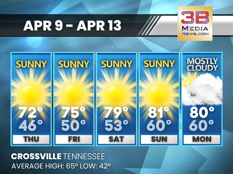
Thursday: Sunny, with a high near 72. South wind around 5 mph.
Thursday Night: Clear, with a low around 46. Calm wind becoming south around 5 mph.
Friday: Sunny, with a high near 75. South wind around 5 mph.
Friday Night: Mostly clear, with a low around 50. Calm wind.
Saturday: Sunny, with a high near 79. Calm wind becoming northwest around 5 mph.
Saturday Night: Mostly clear, with a low around 53. Calm wind.
Sunday: Sunny, with a high near 81. Light south southeast wind becoming south 5 to 10 mph in the morning. Winds could gust as high as 20 mph.
Sunday Night: Mostly cloudy, with a low around 60.
Monday: Mostly cloudy, with a high near 80.
Monday Night: Partly cloudy, with a low around 60.
Almanac for Crossville, Tennessee for April 9
- Normal High Temperature: 65
- Normal Low Temperature: 42
- Record High Temperature: 84 in 1978
- Record Low Temperature: 25 in 1972
- Record Rainfall: 1.46 in 1961
- Record Snowfall: 0.2 in 1973
- Sunrise: 6:15 AM CDT
- Sunset: 7:09 PM CDT
- Next Full Moon: Friday, May 1, 2026 at 12:23 PM CST (known as the Flower Moon; followed by a Blue Moon on Sunday, May 31, 2026 at 3:45 AM CST)
- Spring Solstice: Sunday, June 21, 2026 at 3:24 AM CST
- Daylight Saving Time Ends: Sunday, November 1, 2026 at 2:00 AM CDT
Weather information is provided by the National Weather Service in Nashville and Morristown. You can hear the latest forecast on 105.7 The Hog, 94.1 The Vibe (1410 AM), Spirit 101.9, 98.9 The Wolf, and 93.3 The Ranch (580 AM). Stay connected with Weather Reporter Johnny Caudle on social media by following him on Facebook, X, Instagram, Bluesky, and YouTube. You can also click here to send him an email.