
STORMS DOMINATE THE FORECAST AS TEMPERATURES TREND WARMER
Regional Forecast — Cumberland Plateau & Tennessee Valley
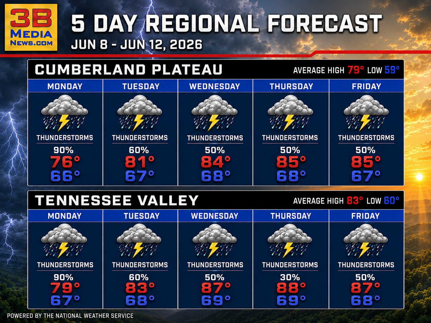
An unsettled weather pattern will bring multiple rounds of showers and thunderstorms through much of the week. Locally heavy rainfall is possible Monday, especially across the Cumberland Plateau, where a Flood Watch remains in effect. Conditions gradually become warmer and more humid as the week progresses.
Monday: Flood Watch. Showers and thunderstorms likely in the morning, becoming widespread during the afternoon. Highs around 76 to 79. Chance of rain 90 percent. Heavy rainfall may produce localized flooding.
Monday Night: Mostly cloudy with showers and thunderstorms likely during the evening, gradually decreasing overnight. Lows around 66 to 67. Chance of rain 50 to 60 percent.
Tuesday: Showers and thunderstorms likely, mainly during the morning and early afternoon, followed by gradual clearing. Highs around 81 to 83. Chance of rain 60 percent.
Tuesday Night: Partly to mostly cloudy with a chance of showers and thunderstorms. Lows around 67 to 68. Chance of rain 30 percent.
Wednesday: Partly sunny to mostly sunny with scattered showers and thunderstorms developing during the day. Highs around 84 to 87. Chance of rain 50 percent.
Wednesday Night: Partly cloudy with a slight chance of an evening thunderstorm, otherwise mainly dry. Lows around 68 to 69.
Thursday: Mostly sunny with scattered afternoon showers and thunderstorms possible. Highs around 85 to 88. Chance of rain 30 to 50 percent.
Thursday Night: Partly cloudy with a slight chance of showers and thunderstorms. Lows around 68 to 69. Chance of rain around 30 percent.
Friday: Mostly sunny, warm, and humid with scattered showers and thunderstorms possible. Highs around 85 to 87. Chance of rain 50 percent.
Friday Night: Partly cloudy with a slight chance of showers and thunderstorms. Lows around 67 to 68. Chance of rain 20 to 30 percent.
June 8 Almanac — Crossville & Rockwood
Temperatures
Crossville: Normal 79° / 59° | Records: 89° (1988) / 42° (1977)
Rockwood: Normal 83° / 60° | Records: 95° (2008) / 40° (1977)
Precipitation Records
Crossville: 2.23″ rain (1978) | 0.0″ snow (2010)
Rockwood: 2.28″ rain (2019) | 0.0″ snow (2025)
Sunrise & Sunset
Crossville: Sunrise 5:23 AM CDT | Sunset 7:56 PM CDT
Rockwood: Sunrise 6:20 AM EDT | Sunset 8:55 PM EDT
Sky & Seasonal Events
Summer Solstice: June 21, 2026
Crossville: 3:24 AM CDT | Rockwood: 4:24 AM EDT
Next Full Moon (Strawberry Moon): June 29, 2026
Crossville: 6:56 PM CDT | Rockwood: 7:56 PM EDT
Daylight Saving Time Ends: November 1, 2026
Crossville: 2:00 AM CDT | Rockwood: 2:00 AM EDT
Weather information is provided by the National Weather Service in Nashville and Morristown. You can hear the latest forecast on 105.7 The Hog, 94.1 The Vibe (1410 AM), Spirit 101.9, 98.9 The Wolf, and 93.3 The Ranch (580 AM). Stay connected with Weather Reporter Johnny Caudle on social media by following him on Facebook, X, Instagram, Bluesky, and YouTube. You can also click here to send him an email.