
ACTIVE WEATHER PATTERN BRINGS STORMS, FOG, AND FALLING TEMPS
Waves of showers and thunderstorms are expected through Sunday, with fog early Wednesday and a break in the heat by the weekend.
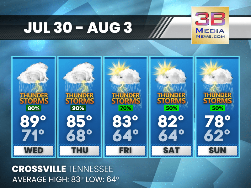
Wednesday: A slight chance of showers and thunderstorms between 10am and 1pm, then showers and possibly a thunderstorm after 1pm. Patchy fog before 8am. High near 89. Heat index values as high as 97. Calm wind becoming south southeast around 5 mph. Chance of precipitation is 80%. New rainfall amounts between a tenth and quarter of an inch, except higher amounts possible in thunderstorms.
Wednesday Night: A chance of showers and thunderstorms. Mostly cloudy, with a low around 71. Calm wind. Chance of precipitation is 50%.
Thursday: A chance of showers before 10am, then a chance of showers and thunderstorms between 10am and 1pm, then showers and possibly a thunderstorm after 1pm. High near 85. Calm wind becoming west around 5 mph in the afternoon. Chance of precipitation is 90%.
Thursday Night: A chance of showers and thunderstorms. Mostly cloudy, with a low around 68. Calm wind. Chance of precipitation is 50%.
Friday: A chance of showers and thunderstorms, then showers likely and possibly a thunderstorm after 1pm. Partly sunny, with a high near 83. Calm wind becoming north around 5 mph in the morning. Chance of precipitation is 70%.
Friday Night: Partly cloudy, with a low around 64. North northeast wind around 5 mph.
Saturday: A 50 percent chance of showers and thunderstorms. Mostly sunny, with a high near 82. Northeast wind around 5 mph.
Saturday Night: A chance of showers and thunderstorms before 1am, then a slight chance of showers. Mostly cloudy, with a low around 64. Chance of precipitation is 30%.
Sunday: A 50 percent chance of showers and thunderstorms. Partly sunny, with a high near 78.
Sunday Night: A 20 percent chance of showers and thunderstorms. Partly cloudy, with a low around 62.
Almanac for Crossville, Tennessee for July 30, 2025:
- Normal High Temperature: 83
- Normal Low Temperature: 64
- Record High Temperature: 93 in 1954
- Record Low Temperature: 51 in 2014
- Sunrise: 5:47 AM CDT
- Sunset: 7:47 PM CDT
- Next Full Moon: Saturday, August 9, 2025 at 3:55 AM CDT (known as the Sturgeon Moon)
- Autumn Equinox: Monday, September 22, 2025 at 1:19 PM CDT
Weather information is provided by the National Weather Service in Nashville and Morristown. Hear the latest forecast on 105.7 The Hog, 94.1 The Vibe (1410 AM), Spirit 101.9, 98.9 The Wolf, and 93.3 The Ranch (580 AM). Get connected with Weathercaster Johnny Caudle on social media. Follow him on Facebook, X, Instagram, Bluesky, and Threads. Click here to send him an email.