

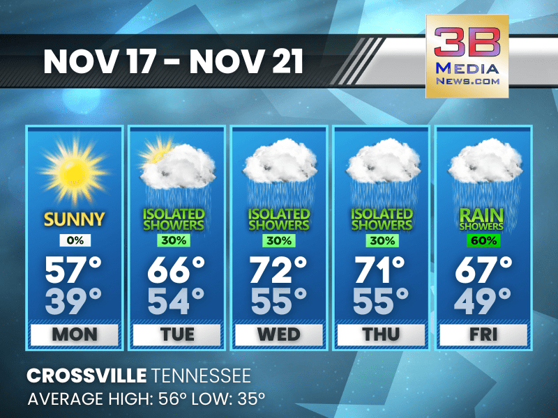
HIGH WINDS THREATEN EAST TENNESSEE MOUNTAIN COUNTIES TUESDAY
A Wind Advisory goes into effect at midnight and continues through 4 p.m. Tuesday for several East Tennessee mountain counties, including Blount, Cocke, Johnson, Sevier,
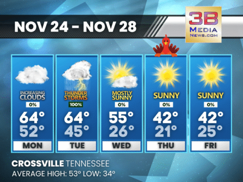
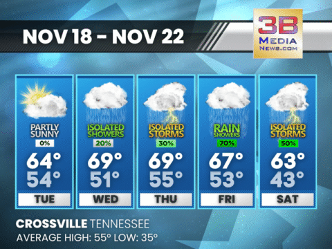
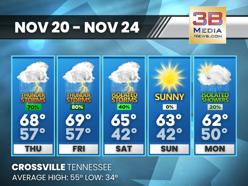
SOAKED TUESDAY AHEAD WITH A LATE-WEEK COLD SNAP
Showers and thunderstorms roll through tonight and Tuesday before a sharp cool-down leads into a sunny but brisk Thanksgiving. Today: Patchy fog before 8am. Otherwise, increasing

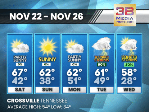
SUNNY SUNDAY AHEAD BEFORE A SOAKING STORM SYSTEM ARRIVES MIDWEEK
A bright and quiet day gives way to fog tonight, mild conditions Monday, and a surge of rain and thunderstorms Tuesday before colder, dry air
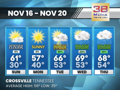
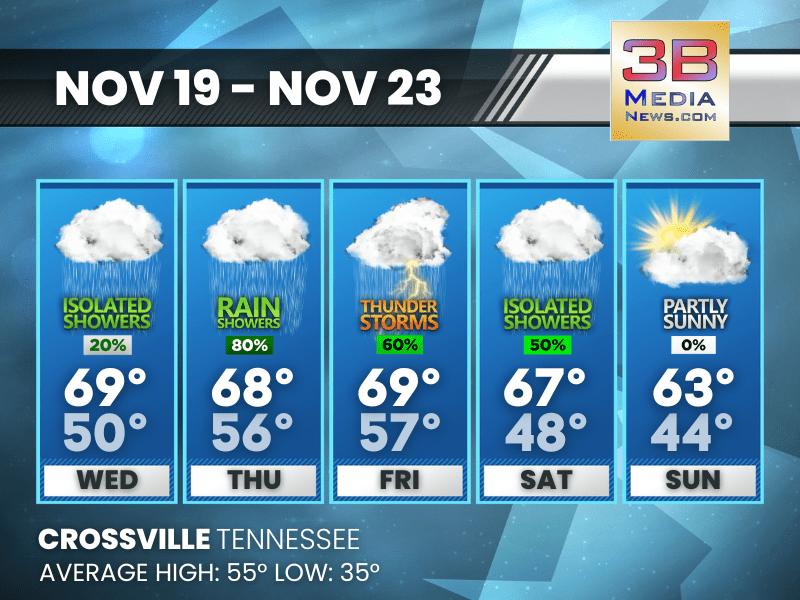
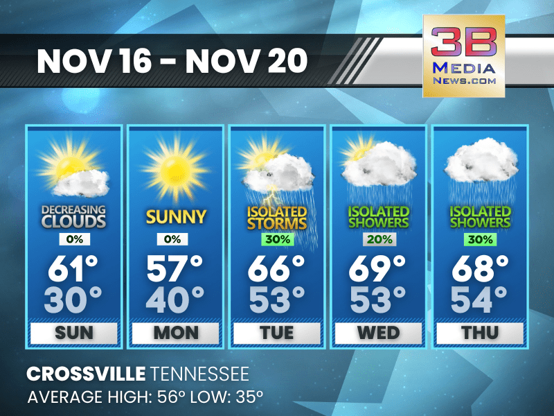
MILD WEEKEND BEFORE A STORMY MIDWEEK SHAKEUP
A pleasant stretch through Monday gives way to a windy, rainy, and possibly stormy Tuesday before cooler air returns midweek. Today: Partly sunny, with a high
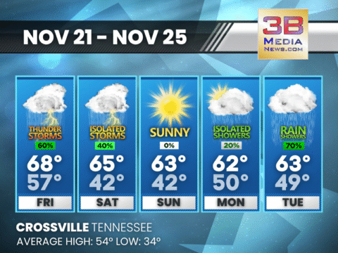
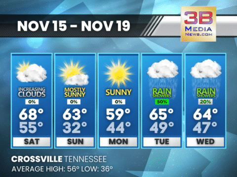
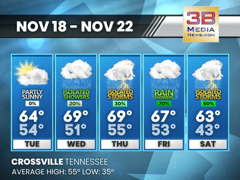
WET WEEKEND KICKS OFF WITH FRIDAY THUNDER THREAT
Showers and a few thunderstorms move in Friday and linger into early Saturday before skies gradually clear for a brighter, cooler Sunday. Friday: Showers likely, with

DENSE FOG BLANKETS EAST AND MIDDLE TENNESSEE THROUGH THE MORNING
A swath of East and Middle Tennessee is starting the day under dense fog advisories, with visibility dropping to a quarter-mile or less in many
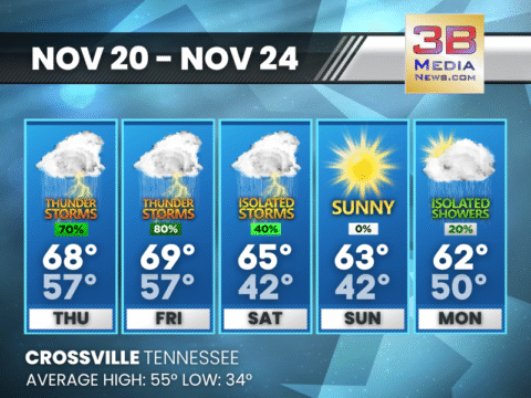
SOAKED LATE WEEK: THUNDERSTORMS ROLL THROUGH BEFORE A CALMER WEEKEND
Rain and thunderstorms dominate Thursday through Friday night before conditions gradually dry out and cooler, calmer weather settles in for the weekend. Thursday: Showers likely and

WET, UNSETTLED WEATHER STRETCHES FROM MIDWEEK INTO THE WEEKEND
A series of showers and thunderstorms will move through from Wednesday night into Saturday before conditions gradually improve late in the weekend. Wednesday: A 20 percent
RAIN BUILDS THROUGH THE WEEK WITH MULTIPLE ROUNDS OF STORMS AHEAD
A quiet, mild Tuesday gives way to several waves of showers and thunderstorms stretching from Tuesday night through the weekend. Tuesday: Partly sunny, with a high

SUNNY START MONDAY, THEN A WET AND WARM MIDWEEK PATTERN SETS IN
A pleasant, calm Monday gives way to increasing shower chances from late Monday night through Friday, with temperatures trending much warmer by midweek. Monday: Sunny, with
MOSTLY CLOUDY SUNDAY GIVES WAY TO A MIDWEEK WARMUP AND PERIODIC SHOWERS
A stretch of quiet, cool weather Sunday and Monday gives way to a warmer, unsettled pattern Tuesday through Thursday, with several chances for showers and
INCREASING CLOUDS SATURDAY, A MIDWEEK SHOWER PATTERN AHEAD
A mild weekend gives way to cooler nights and a return to scattered showers and storms early next week. Saturday: Increasing clouds, with a high near

HIGH WINDS THREATEN EAST TENNESSEE MOUNTAIN COUNTIES TUESDAY
A Wind Advisory goes into effect at midnight and continues through 4 p.m. Tuesday for several East Tennessee mountain counties, including Blount, Cocke, Johnson, Sevier, Southeast Carter, Southeast Gr ...

SOAKED TUESDAY AHEAD WITH A LATE-WEEK COLD SNAP
Showers and thunderstorms roll through tonight and Tuesday before a sharp cool-down leads into a sunny but brisk Thanksgiving. Today: Patchy fog before 8am. Otherwise, increasing clouds, with a hig ...
SUNNY SUNDAY AHEAD BEFORE A SOAKING STORM SYSTEM ARRIVES MIDWEEK
A bright and quiet day gives way to fog tonight, mild conditions Monday, and a surge of rain and thunderstorms Tuesday before colder, dry air settles in for Thanksgiving. Today: Sunny, with a high ...

MILD WEEKEND BEFORE A STORMY MIDWEEK SHAKEUP
A pleasant stretch through Monday gives way to a windy, rainy, and possibly stormy Tuesday before cooler air returns midweek. Today: Partly sunny, with a high near 67. West northwest wind around 5 ...

WET WEEKEND KICKS OFF WITH FRIDAY THUNDER THREAT
Showers and a few thunderstorms move in Friday and linger into early Saturday before skies gradually clear for a brighter, cooler Sunday. Friday: Showers likely, with thunderstorms also possible af ...

DENSE FOG BLANKETS EAST AND MIDDLE TENNESSEE THROUGH THE MORNING
A swath of East and Middle Tennessee is starting the day under dense fog advisories, with visibility dropping to a quarter-mile or less in many spots. In the Cumberland Plateau region—including Cumber ...
SOAKED LATE WEEK: THUNDERSTORMS ROLL THROUGH BEFORE A CALMER WEEKEND
Rain and thunderstorms dominate Thursday through Friday night before conditions gradually dry out and cooler, calmer weather settles in for the weekend. Thursday: Showers likely and possibly a thun ...
WET, UNSETTLED WEATHER STRETCHES FROM MIDWEEK INTO THE WEEKEND
A series of showers and thunderstorms will move through from Wednesday night into Saturday before conditions gradually improve late in the weekend. Wednesday: A 20 percent chance of showers before ...
RAIN BUILDS THROUGH THE WEEK WITH MULTIPLE ROUNDS OF STORMS AHEAD
A quiet, mild Tuesday gives way to several waves of showers and thunderstorms stretching from Tuesday night through the weekend. Tuesday: Partly sunny, with a high near 64. South wind 5 to 15 mph, ...
SUNNY START MONDAY, THEN A WET AND WARM MIDWEEK PATTERN SETS IN
A pleasant, calm Monday gives way to increasing shower chances from late Monday night through Friday, with temperatures trending much warmer by midweek. Monday: Sunny, with a high near 57. Calm win ...
MOSTLY CLOUDY SUNDAY GIVES WAY TO A MIDWEEK WARMUP AND PERIODIC SHOWERS
A stretch of quiet, cool weather Sunday and Monday gives way to a warmer, unsettled pattern Tuesday through Thursday, with several chances for showers and a few thunderstorms. Sunday: Mostly cloudy ...

INCREASING CLOUDS SATURDAY, A MIDWEEK SHOWER PATTERN AHEAD
A mild weekend gives way to cooler nights and a return to scattered showers and storms early next week. Saturday: Increasing clouds, with a high near 68. Southwest wind 5 to 15 mph, with gusts as h ...