
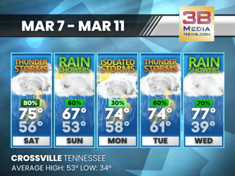
STORMY STRETCH AHEAD WITH ROUNDS OF RAIN THROUGH MIDWEEK
Multiple rounds of rain and thunderstorms are expected from the weekend into midweek, with mild temperatures continuing throughout the period. Today: Showers and thunderstorms likely, then
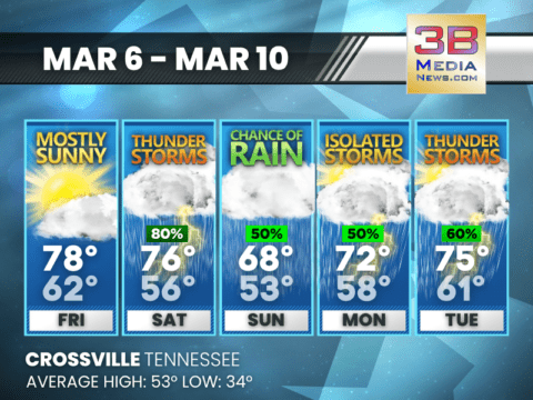
WARM START GIVES WAY TO STORMY STRETCH INTO EARLY WEEK
A warm and mostly sunny Friday is followed by several days of showers and thunderstorms through early next week. Today: Mostly sunny, with a high near

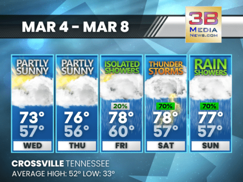
WARM DAYS AHEAD WITH STORM CHANCES PEAKING SATURDAY
Mild temperatures continue through the period, with scattered showers early, a higher storm risk Saturday, and cooler rain chances returning Sunday into Monday. Thursday: A slight
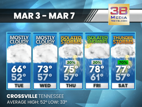
WARM WEEK BEFORE STORMY WEEKEND
Warm temperatures build through Friday before showers and thunderstorms increase heading into the weekend. Wednesday: Partly sunny, with a high near 73. South southwest wind 5
WARMING TREND WITH STORMS LATE WEEK
Temperatures climb well above average midweek before isolated showers and a few thunderstorms move in by Saturday. Tuesday: Mostly cloudy, with a high near 66. South
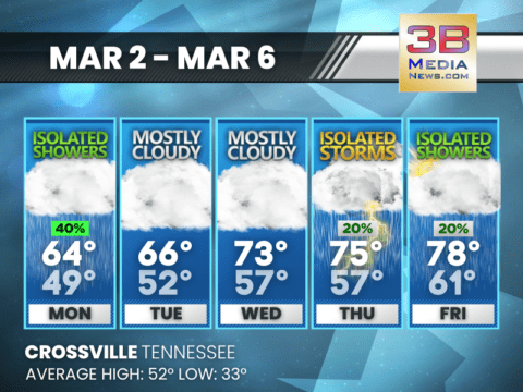
WARMING TREND WITH MIDWEEK STORMS POSSIBLE
Temperatures climb steadily through midweek with mostly cloudy skies before isolated storms arrive Thursday and scattered showers linger into Friday. Today: A 40 percent chance of
CLOUDS RULE THE WEEK, THEN A THURSDAY SHOWER CHANCE
A mostly cloudy pattern holds through midweek with highs pushing the low 70s before isolated showers arrive Thursday. Sunday: Mostly sunny, with a high near 67.
WARM WEEKEND BEFORE SHOWERS RETURN
A sunny Saturday and partly sunny Sunday give way to scattered rain showers and milder temperatures through midweek. Saturday: Sunny, with a high near 67. Calm

SUN-FILLED WEEKEND, SHOWERS NEXT WEEK
Warm sunshine holds through Sunday before rain chances increase Monday and Tuesday. Friday: Sunny, with a high near 63. Calm wind. Friday Night: Patchy fog after 4am.
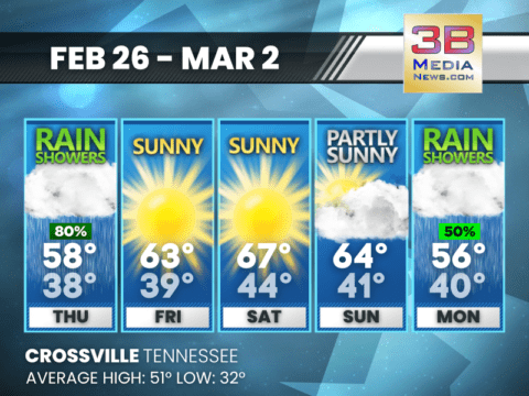
RAINY THURSDAY, BRIGHTER DAYS AHEAD
Showers dominate Thursday before a dry and warmer stretch Friday through Sunday, with rain chances returning Monday. Thursday: Showers and thunderstorms before noon, then a slight
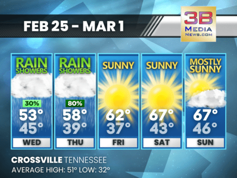
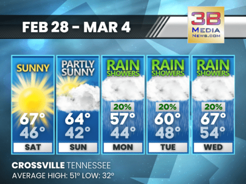
RAIN MIDWEEK, SUNNY WARMING TREND BY WEEKEND
Showers Wednesday and Thursday give way to dry, sunny skies with highs climbing into the upper 60s by the weekend. Today: A 30 percent chance of
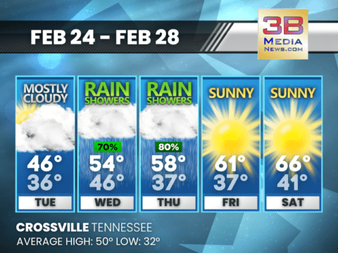
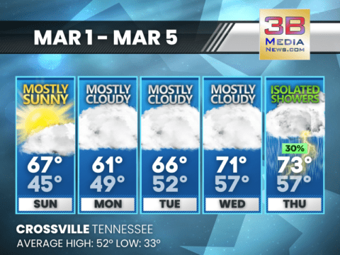
MIDWEEK RAIN, SUNNY FINISH AHEAD
Rain showers Wednesday and Thursday before a sunny, warmer finish to the week. Tuesday: Mostly cloudy, with a high near 46. Light and variable wind becoming
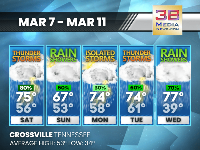
STORMY STRETCH AHEAD WITH ROUNDS OF RAIN THROUGH MIDWEEK
Multiple rounds of rain and thunderstorms are expected from the weekend into midweek, with mild temperatures continuing throughout the period. Today: Showers and thunderstorms likely, then showers ...

WARM START GIVES WAY TO STORMY STRETCH INTO EARLY WEEK
A warm and mostly sunny Friday is followed by several days of showers and thunderstorms through early next week. Today: Mostly sunny, with a high near 78. South wind 5 to 10 mph, with gusts as high ...
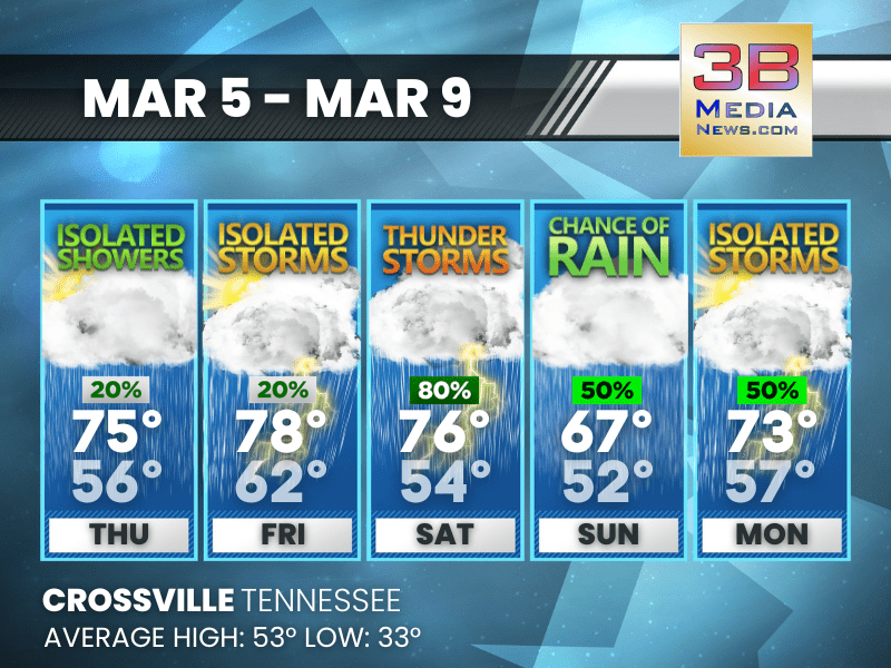
WARM DAYS AHEAD WITH STORM CHANCES PEAKING SATURDAY
Mild temperatures continue through the period, with scattered showers early, a higher storm risk Saturday, and cooler rain chances returning Sunday into Monday. Thursday: A slight chance of showers ...
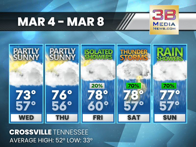
WARM WEEK BEFORE STORMY WEEKEND
Warm temperatures build through Friday before showers and thunderstorms increase heading into the weekend. Wednesday: Partly sunny, with a high near 73. South southwest wind 5 to 10 mph, with gusts ...
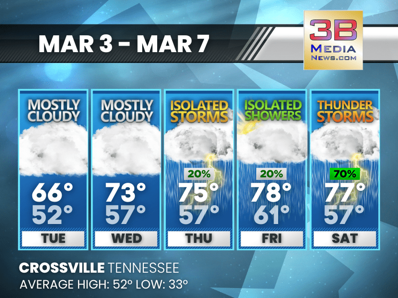
WARMING TREND WITH STORMS LATE WEEK
Temperatures climb well above average midweek before isolated showers and a few thunderstorms move in by Saturday. Tuesday: Mostly cloudy, with a high near 66. South wind 10 to 15 mph, with gusts a ...
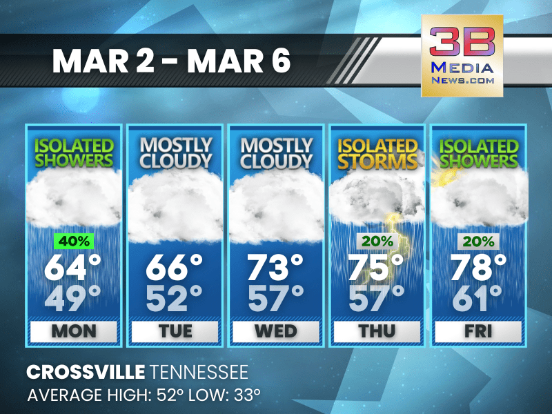
WARMING TREND WITH MIDWEEK STORMS POSSIBLE
Temperatures climb steadily through midweek with mostly cloudy skies before isolated storms arrive Thursday and scattered showers linger into Friday. Today: A 40 percent chance of showers, mainly b ...
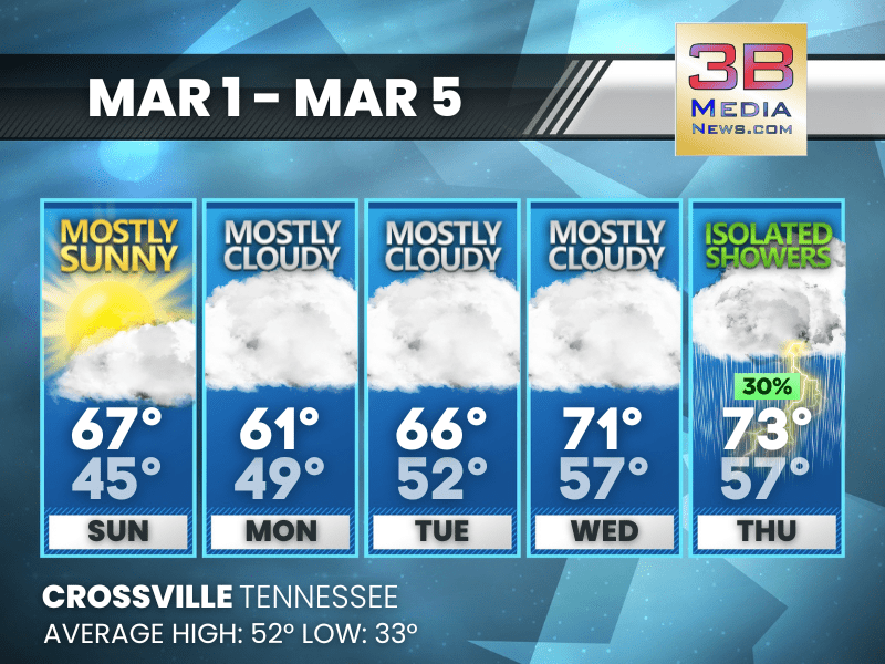
CLOUDS RULE THE WEEK, THEN A THURSDAY SHOWER CHANCE
A mostly cloudy pattern holds through midweek with highs pushing the low 70s before isolated showers arrive Thursday. Sunday: Mostly sunny, with a high near 67. Calm wind becoming west northwest ar ...
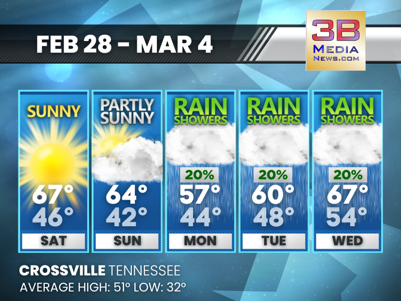
WARM WEEKEND BEFORE SHOWERS RETURN
A sunny Saturday and partly sunny Sunday give way to scattered rain showers and milder temperatures through midweek. Saturday: Sunny, with a high near 67. Calm wind becoming west southwest around 5 ...
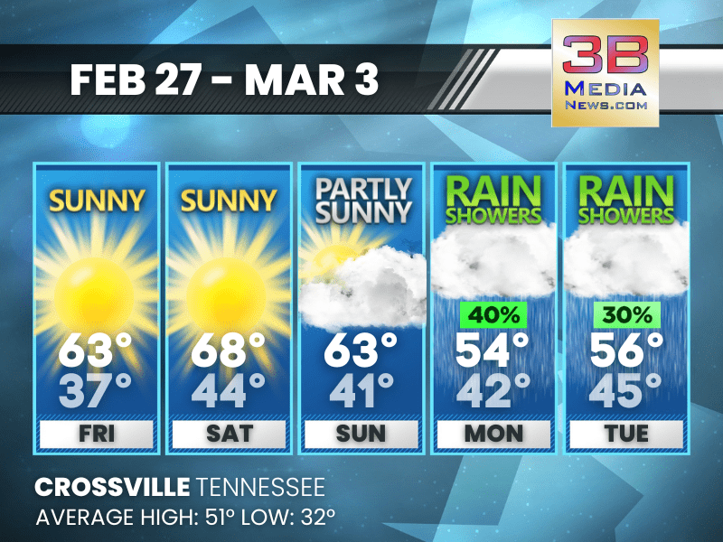
SUN-FILLED WEEKEND, SHOWERS NEXT WEEK
Warm sunshine holds through Sunday before rain chances increase Monday and Tuesday. Friday: Sunny, with a high near 63. Calm wind. Friday Night: Patchy fog after 4am. Otherwise, mostly clear, wi ...

RAINY THURSDAY, BRIGHTER DAYS AHEAD
Showers dominate Thursday before a dry and warmer stretch Friday through Sunday, with rain chances returning Monday. Thursday: Showers and thunderstorms before noon, then a slight chance of showers ...

RAIN MIDWEEK, SUNNY WARMING TREND BY WEEKEND
Showers Wednesday and Thursday give way to dry, sunny skies with highs climbing into the upper 60s by the weekend. Today: A 30 percent chance of showers, mainly after 5pm. Mostly cloudy, with a hig ...

MIDWEEK RAIN, SUNNY FINISH AHEAD
Rain showers Wednesday and Thursday before a sunny, warmer finish to the week. Tuesday: Mostly cloudy, with a high near 46. Light and variable wind becoming southwest 5 to 10 mph in the morning. Wi ...