
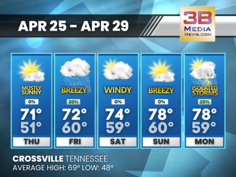
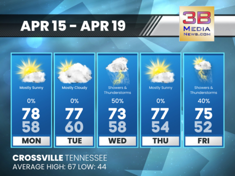
THURSDAY’S 5-DAY FORECAST
Thursday will be another nice day with temperatures climbing into the 70s. Thursday: Mostly sunny, with a high near 71. Northeast wind around 5 mph becoming
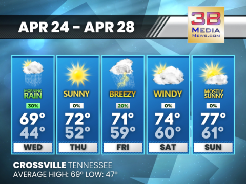
WEDNESDAY’S 5-DAY FORECAST
A few showers possible along the Cumberland Plateau on Wednesday. Wednesday: A 30 percent chance of showers, mainly before 7am. Mostly sunny, with a high near
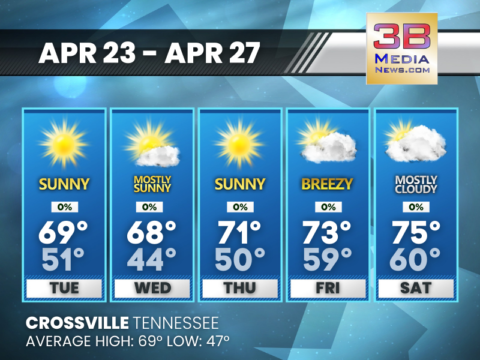
TUESDAY’S 5-DAY FORECAST
Tuesday looks even warmer with winds from the southwest. Tuesday: Sunny, with a high near 69. South southwest wind 5 to 15 mph, with gusts as

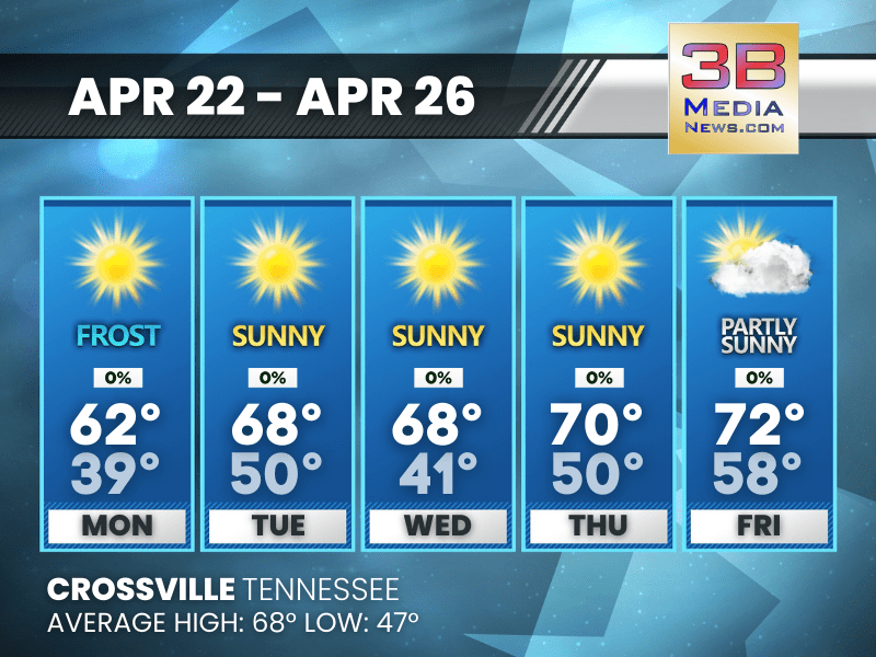
FROST ADVISORY ISSUED
The National Weather Service has issued a Frost Advisory for Bledsoe, Blount, Cumberland, Fentress, Monroe, Morgan, and Pickett Counties in the 3B Media News coverage
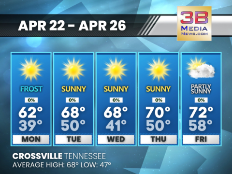
MONDAY’S 5-DAY FORECAST
Monday looks to be a beautiful day as temperatures begin to rebound under sunny skies. Monday: Widespread frost, mainly before 7am. Otherwise, sunny, with a high
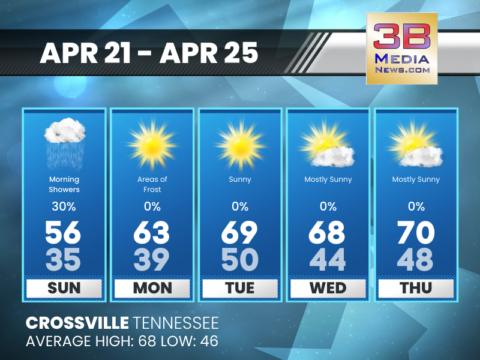
SUNDAY’S 5-DAY FORECAST
After a few early morning light showers on Sunday, skies will once again become partly to mostly sunny. Sunday: A 30 percent chance of showers, mainly
FRIDAY’S 5-DAY FORECAST
Showers and few leftover storms will move out Friday morning, leaving us with cooler conditions. Friday: Showers and thunderstorms likely, mainly before noon. Mostly cloudy, with
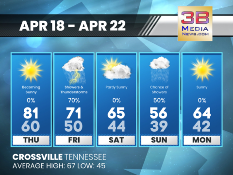
THURSDAY’S 5-DAY FORECAST
Some showers and thunderstorms will move through the area Thursday night into Friday. A few storms may become strong to severe with damaging wind gusts

SEVERE WEATHER?
The National Weather Service has been monitoring the threat for severe weather on Wednesday, and overall, the threat is looking minimal for Middle Tennessee at
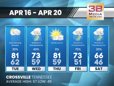
TUESDAY’S 5-DAY FORECAST
Warm temperatures continue today. Tuesday: A 20 percent chance of showers before 9am. Cloudy, then gradually becoming mostly sunny, with a high near 81. South wind
MONDAY’S 5-DAY FORECAST
Warm and dry weather will continue Monday. Monday: Mostly sunny, with a high near 78. West southwest wind 5 to 10 mph. Monday Night: Mostly cloudy, with
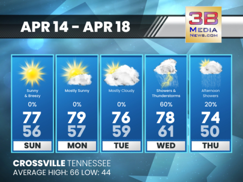
SUNDAY’S 5-DAY FORECAST
Continued warm and dry weather is anticipated. Sunday: Sunny, with a high near 77. West southwest wind 5 to 10 mph increasing to 15 to 20

THURSDAY’S 5-DAY FORECAST
Thursday will be another nice day with temperatures climbing into the 70s. Thursday: Mostly sunny, with a high near 71. Northeast wind around 5 mph becoming southeast in the afternoon. Thursday ...
WEDNESDAY’S 5-DAY FORECAST
A few showers possible along the Cumberland Plateau on Wednesday. Wednesday: A 30 percent chance of showers, mainly before 7am. Mostly sunny, with a high near 69. Northwest wind 5 to 10 mph. Wed ...

TUESDAY’S 5-DAY FORECAST
Tuesday looks even warmer with winds from the southwest. Tuesday: Sunny, with a high near 69. South southwest wind 5 to 15 mph, with gusts as high as 20 mph. Tuesday Night: A 30 percent chance o ...

FROST ADVISORY ISSUED
The National Weather Service has issued a Frost Advisory for Bledsoe, Blount, Cumberland, Fentress, Monroe, Morgan, and Pickett Counties in the 3B Media News coverage area from 1 AM CDT / 2 AM EDT to ...
MONDAY’S 5-DAY FORECAST
Monday looks to be a beautiful day as temperatures begin to rebound under sunny skies. Monday: Widespread frost, mainly before 7am. Otherwise, sunny, with a high near 62. North northeast wind 5 to ...

SUNDAY’S 5-DAY FORECAST
After a few early morning light showers on Sunday, skies will once again become partly to mostly sunny. Sunday: A 30 percent chance of showers, mainly before 11am. Cloudy, then gradually becoming m ...

FRIDAY’S 5-DAY FORECAST
Showers and few leftover storms will move out Friday morning, leaving us with cooler conditions. Friday: Showers and thunderstorms likely, mainly before noon. Mostly cloudy, with a high near 70. So ...

THURSDAY’S 5-DAY FORECAST
Some showers and thunderstorms will move through the area Thursday night into Friday. A few storms may become strong to severe with damaging wind gusts the primary threat. Thursday: Partly sunny, t ...

SEVERE WEATHER?
The National Weather Service has been monitoring the threat for severe weather on Wednesday, and overall, the threat is looking minimal for Middle Tennessee at this time. The latest Severe Weather Out ...

TUESDAY’S 5-DAY FORECAST
Warm temperatures continue today. Tuesday: A 20 percent chance of showers before 9am. Cloudy, then gradually becoming mostly sunny, with a high near 81. South wind 5 to 10 mph, with gusts as high a ...

MONDAY’S 5-DAY FORECAST
Warm and dry weather will continue Monday. Monday: Mostly sunny, with a high near 78. West southwest wind 5 to 10 mph. Monday Night: Mostly cloudy, with a low around 58. South southwest wind aro ...
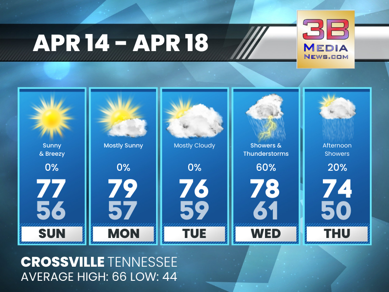
SUNDAY’S 5-DAY FORECAST
Continued warm and dry weather is anticipated. Sunday: Sunny, with a high near 77. West southwest wind 5 to 10 mph increasing to 15 to 20 mph in the afternoon. Winds could gust as high as 30 mph. ...