
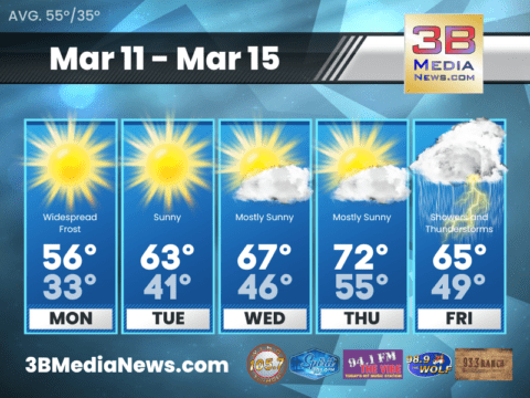
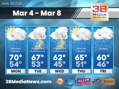
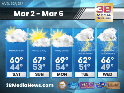
MONDAY’S 5-DAY FORECAST
Warmer temperatures ahead. Monday: Widespread frost before 9am. Otherwise, sunny, with a high near 56. North wind around 5 mph. Monday Night: Mostly clear, with a low
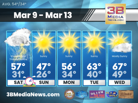
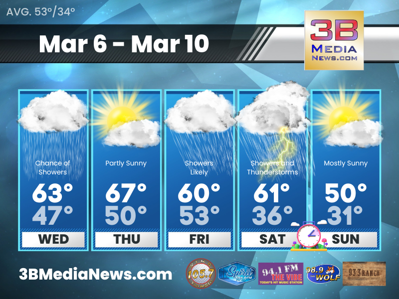
SATURDAY’S 5-DAY FORECAST
A wet start to the weekend; clocks spring forward tonight with the daylight saving time change; and pleasant weather returns tomorrow, but a little on
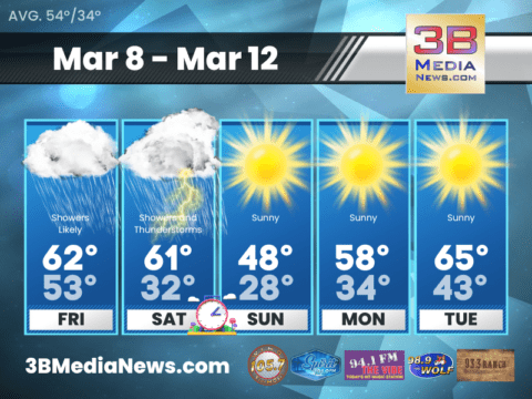
FRIDAY’S 5-DAY FORECAST
Heavy rain and thunderstorms possible this weekend. Friday: Showers likely, mainly after 2pm. Cloudy, with a high near 62. South southeast wind 5 to 15 mph,
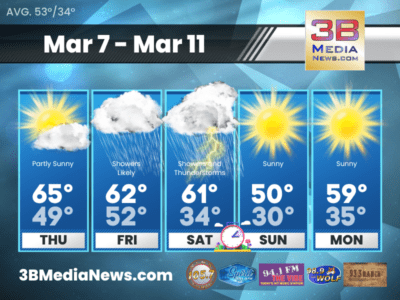
THURSDAY’S 5-DAY FORECAST
Drier weather and warmer on Thursday before the rain returns. Thursday: Patchy fog before 7am. Otherwise, partly sunny, with a high near 65. North northeast
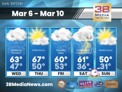
WEDNESDAY’S 5-DAY FORECAST
Rain will continue on Wednesday before coming to an end late in the day. Warm and dry on Thursday before another system brings more rain
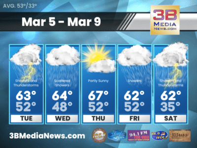
TUESDAY’S 5-DAY FORECAST
Rain and some thunderstorms possible Tuesday. We’re not expecting any strong to severe storms at this time. Tuesday: Showers likely, with thunderstorms possible after noon.
MONDAY’S 5-DAY FORECAST
Warm and wet going into the new week. Monday: A 20 percent chance of showers after noon. Partly sunny, with a high near 70. South
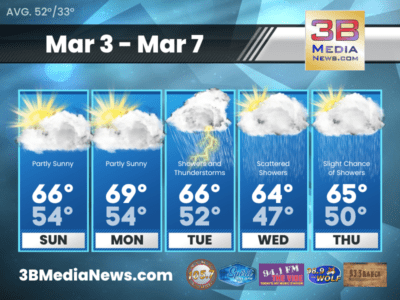
SUNDAY’S 5-DAY FORECAST
Highs continue to look like they will be quite seasonably warm on Sunday. Sunday: Partly sunny, with a high near 66. South wind 5 to
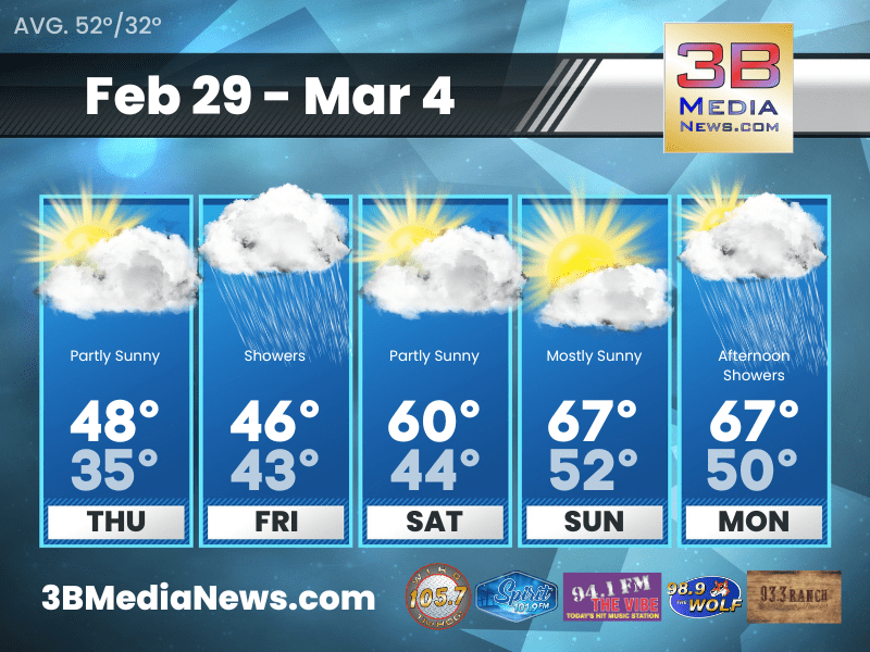
SATURDAY’S 5-DAY FORECAST
Saturday will become a nicer day, but it will take a while to get there with widespread clouds and areas of fog in the morning.
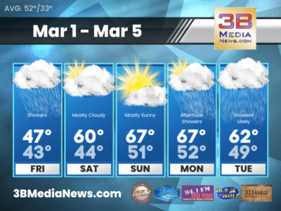
FRIDAY’S 5-DAY FORECAST
Rain returns Friday. Warming trend and drier conditions this weekend. Friday: Showers. High near 47. South southeast wind around 10 mph, with gusts as high

THURSDAY’S 5-DAY FORECAST
Quiet weather is on tap for today. Our next round of rain arrives late tonight. While a rumble of thunder or two can’t be ruled

TORNADO WATCH ISSUED FOR WAYNE, CUMBERLAND, AND CLINTON COUNTY KENTUCKY
The National Weather Service has issued a tornado watch for many counties in Kentucky including Wayne, Cumberland, and Clinton County in the 98.9 The Wolf

MONDAY’S 5-DAY FORECAST
Warmer temperatures ahead. Monday: Widespread frost before 9am. Otherwise, sunny, with a high near 56. North wind around 5 mph. Monday Night: Mostly clear, with a low around 33. West wind around ...

SATURDAY’S 5-DAY FORECAST
A wet start to the weekend; clocks spring forward tonight with the daylight saving time change; and pleasant weather returns tomorrow, but a little on the cool side. Saturday: Showers and thunderst ...

FRIDAY’S 5-DAY FORECAST
Heavy rain and thunderstorms possible this weekend. Friday: Showers likely, mainly after 2pm. Cloudy, with a high near 62. South southeast wind 5 to 15 mph, with gusts as high as 30 mph. Chance of ...

THURSDAY’S 5-DAY FORECAST
Drier weather and warmer on Thursday before the rain returns. Thursday: Patchy fog before 7am. Otherwise, partly sunny, with a high near 65. North northeast wind around 5 mph becoming east southeas ...
WEDNESDAY’S 5-DAY FORECAST
Rain will continue on Wednesday before coming to an end late in the day. Warm and dry on Thursday before another system brings more rain to the area Friday and Saturday. Wednesday: A 50 percent cha ...

TUESDAY’S 5-DAY FORECAST
Rain and some thunderstorms possible Tuesday. We're not expecting any strong to severe storms at this time. Tuesday: Showers likely, with thunderstorms possible after noon. Mostly cloudy, with a hi ...

MONDAY’S 5-DAY FORECAST
Warm and wet going into the new week. Monday: A 20 percent chance of showers after noon. Partly sunny, with a high near 70. South wind around 10 mph. Monday Night: A slight chance of showers bef ...

SUNDAY’S 5-DAY FORECAST
Highs continue to look like they will be quite seasonably warm on Sunday. Sunday: Partly sunny, with a high near 66. South wind 5 to 10 mph. Sunday Night: Partly cloudy, with a low around 54. So ...

SATURDAY’S 5-DAY FORECAST
Saturday will become a nicer day, but it will take a while to get there with widespread clouds and areas of fog in the morning. Saturday: Mostly cloudy, with a high near 60. South southwest wind ar ...

FRIDAY’S 5-DAY FORECAST
Rain returns Friday. Warming trend and drier conditions this weekend. Friday: Showers. High near 47. South southeast wind around 10 mph, with gusts as high as 25 mph. Chance of precipitation is 90 ...
THURSDAY’S 5-DAY FORECAST
Quiet weather is on tap for today. Our next round of rain arrives late tonight. While a rumble of thunder or two can't be ruled out, this should just be rain with no severe weather concerns. Thursd ...

TORNADO WATCH ISSUED FOR WAYNE, CUMBERLAND, AND CLINTON COUNTY KENTUCKY
The National Weather Service has issued a tornado watch for many counties in Kentucky including Wayne, Cumberland, and Clinton County in the 98.9 The Wolf coverage area. The watch is set to expire ...