
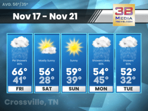
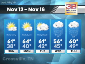
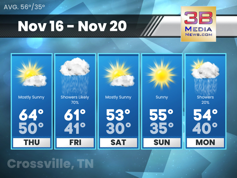
Friday’s 5-Day Forecast
Rain Friday with a passing cold front. Potential for a more significant rainfall event Monday into Tuesday. Friday: Showers, mainly after noon. High near 66.

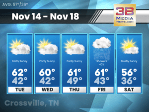
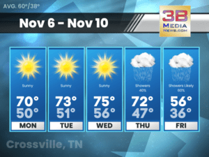
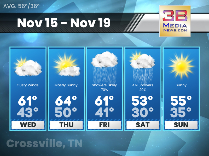
Thursday’s 5-Day Forecast
A chance of rain returns to the forecast late tonight. Thursday: Mostly sunny, with a high near 64. South southeast wind 5 to 10 mph.
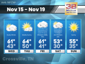
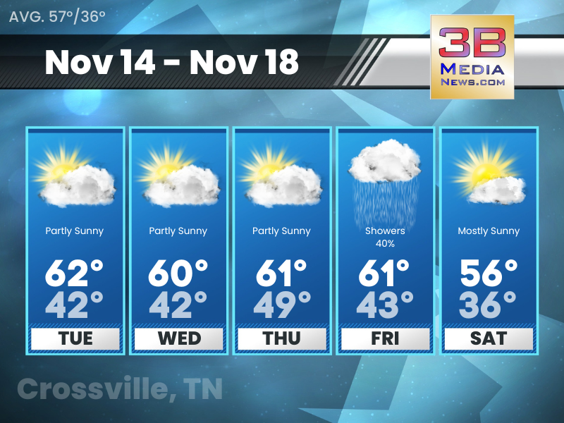
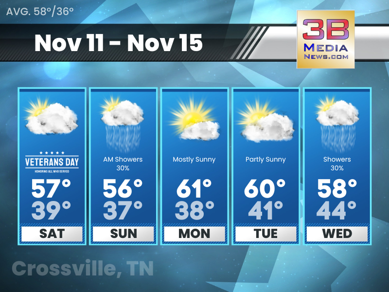
Wednesday’s 5-Day Forecast
We’re going to get some rain later this week, but it isn’t going to be much. Wednesday: Mostly cloudy, with a high near 61. South
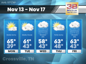
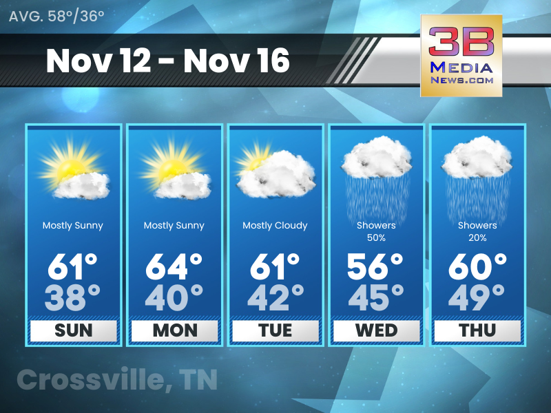
Tuesday’s 5-Day Forecast
Low relative humidity Tuesday and Wednesday afternoons pose fire weather risks. Tuesday: Partly sunny, with a high near 62. East wind 5 to 10 mph.
Monday’s 5-Day Forecast
Dry with a warming trend for the first half of the week, with chances of rain mid to late week. Monday: Mostly sunny, with a
Sunday’s 5-Day Forecast
Sunday looks to be similar to Saturday except just a tad warmer. Sunday: Mostly sunny, with a high near 61. Northeast wind around 5 mph.

Saturday’s 5-Day Forecast
Cooler this weekend. Dry with a warming trend for the first half of next week. Veterans Day: Partly sunny, with a high near 57. Northeast
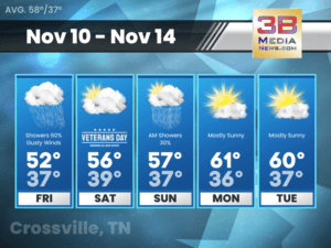
Friday’s 5-Day Forecast
Friday will bring the hoodies and jackets back out with highs only in the 50s, so be prepared for that. Friday: Showers likely, mainly before

Thursday’s 5-Day Forecast
Much needed rainfall is on the way! Still forecasted to arrive on Thursday and spread across the area Thursday night and Friday, this slow-moving frontal

Wednesday’s 5-Day Forecast
Thursday and Friday continue to be the main focus for rainfall this week. We’re only expecting showers with this system, but don’t be surprised to
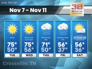
Tuesday’s 5-Day Forecast
Dry, warm above normal temperatures, and mostly clear skies with increasing southwest winds. Tuesday: Sunny, with a high near 75. West southwest wind 5 to
Monday’s 5-Day Forecast
Dry weather continues through at least Wednesday. Rain chances return Thursday into Friday with a cold front. Well above normal temperatures midweek, with worsening drought

Friday’s 5-Day Forecast
Rain Friday with a passing cold front. Potential for a more significant rainfall event Monday into Tuesday. Friday: Showers, mainly after noon. High near 66. South wind 5 to 10 mph becoming west in t ...
Thursday’s 5-Day Forecast
A chance of rain returns to the forecast late tonight. Thursday: Mostly sunny, with a high near 64. South southeast wind 5 to 10 mph. Thursday Night: A 20 percent chance of showers after midnight. M ...
Wednesday’s 5-Day Forecast
We're going to get some rain later this week, but it isn't going to be much. Wednesday: Mostly cloudy, with a high near 61. South southeast wind 5 to 10 mph, with gusts as high as 20 mph. Wednesday ...
Tuesday’s 5-Day Forecast
Low relative humidity Tuesday and Wednesday afternoons pose fire weather risks. Tuesday: Partly sunny, with a high near 62. East wind 5 to 10 mph. Tuesday Night: Mostly cloudy, with a low around 42. ...

Monday’s 5-Day Forecast
Dry with a warming trend for the first half of the week, with chances of rain mid to late week. Monday: Mostly sunny, with a high near 65. Calm wind becoming north around 5 mph in the afternoon. Mon ...
Sunday’s 5-Day Forecast
Sunday looks to be similar to Saturday except just a tad warmer. Sunday: Mostly sunny, with a high near 61. Northeast wind around 5 mph. Sunday Night: Partly cloudy, with a low around 38. Northeast ...
Saturday’s 5-Day Forecast
Cooler this weekend. Dry with a warming trend for the first half of next week. Veterans Day: Partly sunny, with a high near 57. Northeast wind 5 to 10 mph. Saturday Night: A 20 percent chance of sho ...
Friday’s 5-Day Forecast
Friday will bring the hoodies and jackets back out with highs only in the 50s, so be prepared for that. Friday: Showers likely, mainly before 10am. Mostly cloudy, with a high near 52. North northeast ...

Thursday’s 5-Day Forecast
Much needed rainfall is on the way! Still forecasted to arrive on Thursday and spread across the area Thursday night and Friday, this slow-moving frontal boundary should provide us with an average of ...

Wednesday’s 5-Day Forecast
Thursday and Friday continue to be the main focus for rainfall this week. We're only expecting showers with this system, but don't be surprised to hear a rumble of thunder at some point Thursday night ...

Tuesday’s 5-Day Forecast
Dry, warm above normal temperatures, and mostly clear skies with increasing southwest winds. Tuesday: Sunny, with a high near 75. West southwest wind 5 to 10 mph. Tuesday Night: Mostly clear, with a ...

Monday’s 5-Day Forecast
Dry weather continues through at least Wednesday. Rain chances return Thursday into Friday with a cold front. Well above normal temperatures midweek, with worsening drought conditions. Monday: Sunny, ...