
CHANGING WEATHER AHEAD: SUNNY TODAY, COLDER BY MONDAY
After a pleasant Thursday, rain and thunderstorms return Friday before a weekend cool-down brings a sharp drop into the 20s by Sunday night.
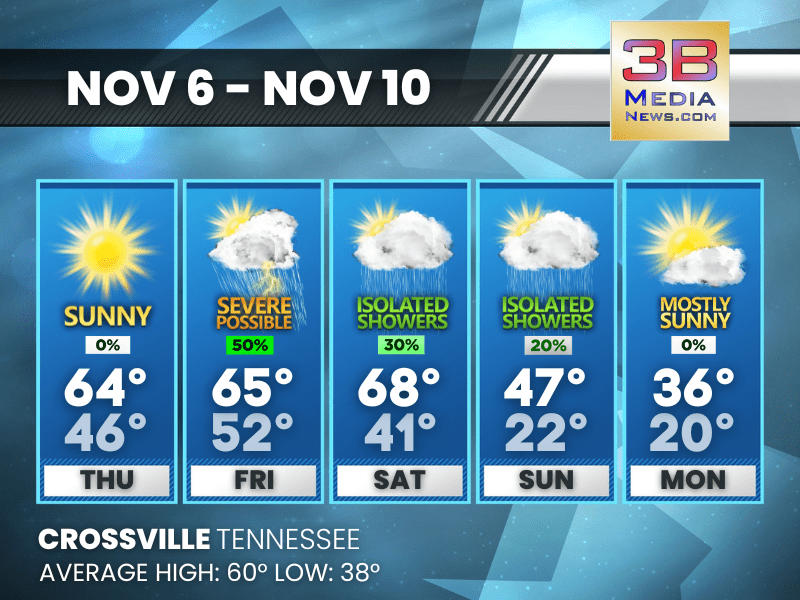
Today: Sunny, with a high near 64. Northeast wind around 5 mph becoming east southeast in the afternoon.
Tonight: Mostly clear, with a low around 46. South wind 5 to 10 mph, with gusts as high as 25 mph.
Friday: A chance of showers between noon and 3pm, then a chance of showers and thunderstorms after 3pm. Partly sunny, with a high near 65. South southwest wind 10 to 15 mph, with gusts as high as 25 mph. Chance of precipitation is 50%. New rainfall amounts of less than a tenth of an inch, except higher amounts possible in thunderstorms.
Friday Night: Showers and possibly a thunderstorm before midnight, then a chance of showers. Low around 52. South southwest wind 5 to 10 mph becoming light and variable after midnight. Winds could gust as high as 20 mph. Chance of precipitation is 80%.
Saturday: A 30 percent chance of showers after noon. Mostly sunny, with a high near 68. Calm wind becoming south southwest around 5 mph.
Saturday Night: Showers likely, mainly before midnight. Mostly cloudy, with a low around 41. South wind 5 to 10 mph becoming west northwest after midnight. Winds could gust as high as 20 mph. Chance of precipitation is 60%.
Sunday: A 20 percent chance of showers. Mostly cloudy, with a high near 47. Northwest wind 10 to 15 mph, with gusts as high as 25 mph.
Sunday Night: A slight chance of rain and snow showers before midnight, then a slight chance of snow showers. Partly cloudy, with a low around 22. Northwest wind around 10 mph, with gusts as high as 25 mph. Chance of precipitation is 20%.
Monday: Mostly sunny, with a high near 36. West northwest wind 10 to 15 mph, with gusts as high as 25 mph.
Monday Night: Mostly clear, with a low around 20.
Almanac for Crossville, Tennessee for November 6
- Normal High Temperature: 60
- Normal Low Temperature: 38
- Record High Temperature: 73 in 1978
- Record Low Temperature: 19 in 1967
- Record High Rainfall: 0.94 in 1995
- Record Snowfall: Trace in 1992
- Sunrise: 6:08 AM CST
- Sunset: 4:40 PM CST
- Next Full Moon: Thursday, November 4, 2025 at 5:14 PM CST (known as the Cold Moon; this full moon will also be a supermoon)
- Winter Solstice: Sunday, December 21, 2025 at 9:03 AM CST
- Daylight Saving Time Begins: Sunday, March 8, 2026 at 2:00 AM EDT
Weather information is provided by the National Weather Service in Nashville and Morristown. You can hear the latest forecast on 105.7 The Hog, 94.1 The Vibe (1410 AM), Spirit 101.9, 98.9 The Wolf, and 93.3 The Ranch (580 AM). Stay connected with Weathercaster Johnny Caudle on social media by following him on Facebook, X, Instagram, Bluesky, and Threads. You can also click here to send him an email.