
COLD, DRY START WITH A MIDWEEK WARMUP
A stretch of sunny, chilly days leads into a milder pattern by midweek.
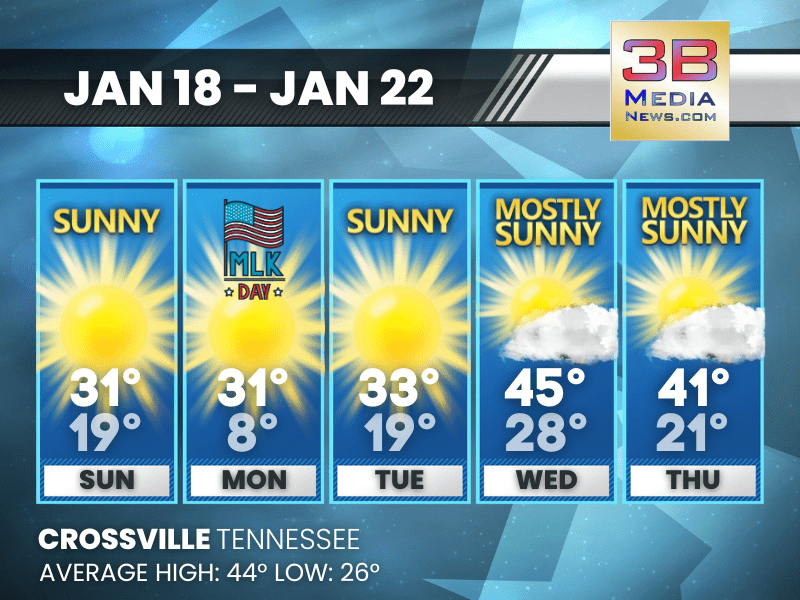
Sunday: Sunny, with a high near 31. Calm wind becoming west around 5 mph in the morning.
Sunday Night: Mostly clear, with a low around 19. West southwest wind 5 to 10 mph, with gusts as high as 20 mph.
M.L.King Day: Sunny, with a high near 31. West northwest wind 5 to 10 mph, with gusts as high as 20 mph.
Monday Night: Partly cloudy, with a low around 8. Northwest wind around 5 mph becoming calm in the evening.
Tuesday: Sunny, with a high near 33. Calm wind becoming west northwest around 5 mph.
Tuesday Night: Mostly clear, with a low around 19. Calm wind becoming south around 5 mph after midnight.
Wednesday: Mostly sunny, with a high near 45. South southwest wind 5 to 10 mph, with gusts as high as 20 mph.
Wednesday Night: A slight chance of rain and snow showers before midnight, then a slight chance of snow showers. Mostly cloudy, with a low around 28. South southwest wind around 5 mph becoming west after midnight. Chance of precipitation is 20%.
Almanac for Crossville, Tennessee for January 18
- Normal High Temperature: 44
- Normal Low Temperature: 26
- Record High Temperature: 62 in 1996
- Record Low Temperature: -8 in 1994
- Record Rainfall: 1.42 in 1987
- Record Snowfall: 4.0 in 1955
- Sunrise: 6:49 AM CST
- Sunset: 4:53 PM CST
- Next Full Moon: Sunday, February 1, 2026 at 5:09 AM CST (known as the Snow Moon)
- Daylight Saving Time Begins: Sunday, March 8, 2026 at 2:00 AM EDT
- Spring Equinox: Friday, March 20, 2026 at 9:46 AM CST
Weather information is provided by the National Weather Service in Nashville and Morristown. You can hear the latest forecast on 105.7 The Hog, 94.1 The Vibe (1410 AM), Spirit 101.9, 98.9 The Wolf, and 93.3 The Ranch (580 AM). Stay connected with Weather Reporter Johnny Caudle on social media by following him on Facebook, X, Instagram, Bluesky, Mastodon, TikTok, YouTube, and Threads. You can also click here to send him an email.