
GULF COAST COULD BE HIT BY TWO HURRICANES…WITHIN A 12 HOUR PERIOD
The National Weather Service is watching two tropical depressions this morning approaching the Gulf of Mexico.
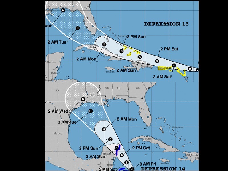
TROPICAL DEPRESSION 13 – As of 8 a.m. eastern this morning (Friday, August 21, 2020) the center of Tropical Depression 13 was located near latitude 17.9 north, longitude 59.2 west. The depression is moving toward the west-northwest near 21 mph and this motion is expected to continue for the next few days. On the forecast track, the depression is expected to move near or north of the northern Leeward Islands later today, near or north of the Virgin Islands and Puerto Rico on Saturday, and near or north of Hispaniola Saturday night. Maximum sustained winds remain near 35 mph with higher gusts. Gradual strengthening is forecast, and the depression is likely to become a tropical storm by the weekend. If it stays on its present projected path, it will be a hurricane Tuesday just west of Tampa, Florida and make landfall early Wednesday morning before sunrise near Pensacola, Florida.
TROPICAL DEPRESSION 14 – At 8 a.m. eastern this morning (Friday, August 21, 2020), Tropical Depression 14 has maximum sustained winds near 35 mph with higher gusts. Strengthening is forecast during the next couple of days and the depression is expected to become a tropical storm later today. The system is forecast to be near or at hurricane strength when it reaches the Yucatan Peninsula of Mexico late Saturday. Some weakening is expected as it traverses the Yucatan Peninsula Saturday night. Afterward, re-strengthening is forecast on Sunday as it moves offshore and enters the southern Gulf of Mexico. On this course, the storm will turn into a hurricane in the gulf and make landfall Tuesday August 25, 2020 on the Texas or Louisiana coast.
Anyone with family or friends in these two areas are encouraged to monitor the daily progression of both storms. Residents along the gulf coast from Texas east to Florida should watch for further updates on the progression of these two storms.
