
LAURA NOW FORECAST TO BE A CATASTROPHIC CATEGORY 4 HURRICANE
An intensifying Hurricane Laura is growing stronger by the hour today (Wednesday, August 26, 2020) over the Gulf of Mexico as forecasters warn the powerful system will be a “catastrophic” Category 4 storm before it makes landfall along the Gulf Coast.
The U.S. National Hurricane Center (NHC) in Miami said this morning that Laura, now a major hurricane, is forecast to “rapidly strengthen” throughout the day, bringing life-threatening storm surge, extreme winds, and flash flooding over eastern Texas and Louisiana.
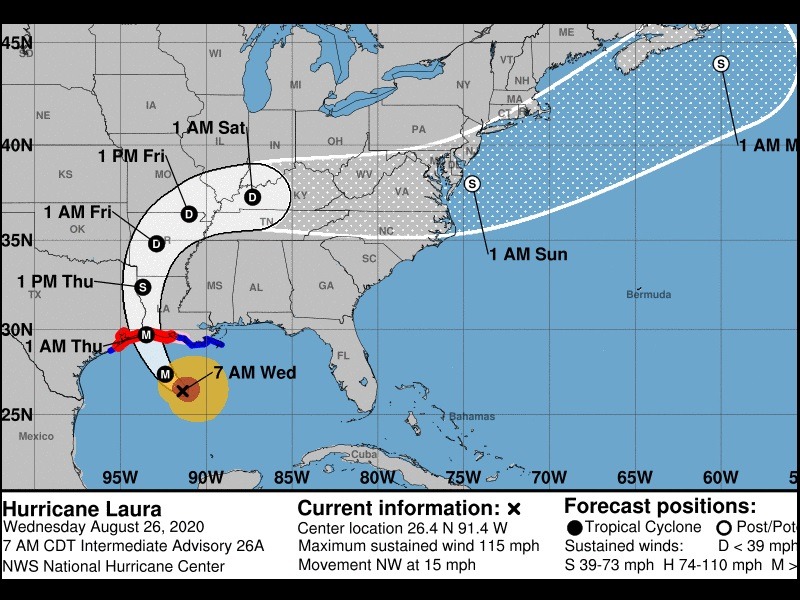
As of 8 a.m. eastern today, the storm is located about 280 miles south-southeast of Lake Charles, Louisiana, moving northwest at 15 mph with maximum sustained winds of 115 mph.
Laura is now a dangerous Category 3 hurricane that continues to intensify in the Gulf of Mexico.
Satellite images show that Laura has become “a formidable hurricane” in recent hours, threatening to smash homes and sink entire communities.
Laura has undergone a remarkable intensification, growing nearly 70% in power in just 24 hours “and there are no signs it will stop soon,” the NHC said.
The 8 a.m.. advisory from the NHC has Laura becoming a Category 4 storm before making landfall overnight.
Laura is becoming a large hurricane as it strengthens by the hour, with hurricane-force winds extending 70 miles from the center and tropical-storm-force winds extending outward of up to 175 miles.
Laura is forecast to make landfall as a major hurricane with winds upwards of 115 mph on the border between Texas and Louisiana early Thursday morning, but conditions are going to go downhill through the day on Wednesday.
Impacts and hazards from the storm will be widespread – not just where the center of the storm makes landfall.
A life-threatening storm surge of 7 to 15 feet will inundate the coast just east of the trajectory. A storm surge warning is in effect from Freeport, Texas to the mouth of the Mississippi River.
According to the NHC, the worst of the storm surge will be along the immediate coast near and to the right of the landfall location, where the surge will be accompanied by “large and destructive waves.”
“This storm surge could penetrate up to 30 miles inland from the immediate coastline in southwestern Louisiana and far southeastern Texas,” forecasters said.
Hurricane-force winds for several hours will cause damage to homes, businesses, and trees. Power outages are also expected.
A hurricane warning is in effect from San Luis Pass, Texas to Intracoastal City in Louisiana.
Flooding will also be widespread from the hurricane. Anywhere between 5 to 10 inches of rain is expected, with isolated totals of 12-15 inches which will cause dangerous conditions along the coast and well inland.
Laura’s arrival comes just days before the Aug. 29 anniversary of Hurricane Katrina, which breached the levees in New Orleans, flattened much of the Mississippi coast, and killed as many as 1,800 people in 2005. Less than a month later, Hurricane Rita struck southwest Louisiana as a Category 3 storm.