
MIDWEEK RAIN GIVES WAY TO A COLDER, BRIGHTER FINISH
Rain clears out Wednesday, followed by a steady cool-down and increasing sunshine through the weekend.
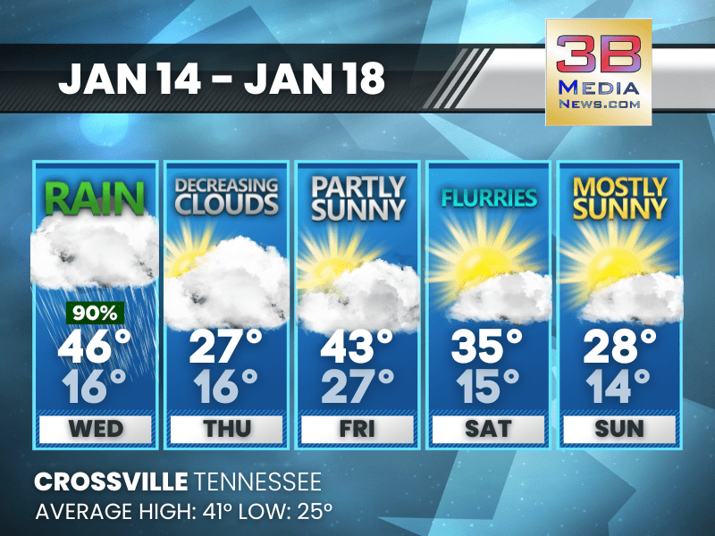
Today: Rain before 5pm, then a chance of rain and snow. High near 46. Southwest wind 5 to 10 mph becoming northwest in the afternoon. Winds could gust as high as 25 mph. Chance of precipitation is 90%. Little or no snow accumulation expected.
Tonight: A chance of rain and snow before 7pm, then a chance of snow between 7pm and midnight, then a chance of flurries after midnight. Mostly cloudy, with a low around 16. North northwest wind 10 to 15 mph, with gusts as high as 25 mph. Chance of precipitation is 40%. New snow accumulation of less than a half inch possible.
Thursday: Mostly cloudy, then gradually becoming sunny, with a high near 27. West northwest wind 5 to 10 mph, with gusts as high as 20 mph.
Thursday Night: Mostly clear, with a low around 16. Calm wind becoming south around 5 mph after midnight. Winds could gust as high as 20 mph.
Friday: Partly sunny, with a high near 43. Southwest wind 10 to 15 mph, with gusts as high as 25 mph.
Friday Night: A chance of rain and snow showers before midnight, then a chance of snow showers. Mostly cloudy, with a low around 27. West southwest wind 5 to 10 mph, with gusts as high as 20 mph. Chance of precipitation is 30%.
Saturday: A chance of flurries before 1pm, then a chance of sprinkles and flurries between 1pm and 4pm, then a chance of flurries after 4pm. Mostly sunny, with a high near 35. West wind 5 to 15 mph, with gusts as high as 25 mph.
Saturday Night: A chance of flurries after midnight. Mostly cloudy, with a low around 15. Southwest wind 5 to 10 mph, with gusts as high as 20 mph.
Sunday: Mostly sunny, with a high near 28. West wind 10 to 15 mph, with gusts as high as 25 mph.
Sunday Night: Mostly clear, with a low around 14.
Almanac for Crossville, Tennessee for January 14
- Normal High Temperature: 44
- Normal Low Temperature: 26
- Record High Temperature: 65 in 2007
- Record Low Temperature: -1 in 1963
- Record Rainfall: 1.93 in 1995
- Record Snowfall: 0.2 in 1982
- Sunrise: 6:50 AM CST
- Sunset: 4:49 PM CST
- Next Full Moon: Sunday, February 1, 2026 at 5:09 AM CST (known as the Snow Moon)
- Daylight Saving Time Begins: Sunday, March 8, 2026 at 2:00 AM EDT
- Spring Equinox: Friday, March 20, 2026 at 9:46 AM CST
Weather information is provided by the National Weather Service in Nashville and Morristown. You can hear the latest forecast on 105.7 The Hog, 94.1 The Vibe (1410 AM), Spirit 101.9, 98.9 The Wolf, and 93.3 The Ranch (580 AM). Stay connected with Weather Reporter Johnny Caudle on social media by following him on Facebook, X, Instagram, Bluesky, Mastodon, TikTok, YouTube, and Threads. You can also click here to send him an email.