
MONDAY’S 5 DAY FORECAST
Monday’s Hazardous Weather Outlook for East Tennessee: A cold front will move through Monday afternoon and evening. A few strong storms may accompany this front. These storms could produce some marginally severe winds.
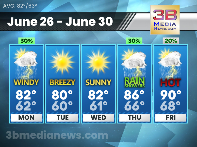
Monday: A 30 percent chance of showers and thunderstorms, mainly before 7am. Mostly sunny, with a high near 82. West southwest wind 10 to 15 mph, with gusts as high as 25 mph.
Monday Night: Mostly clear, with a low around 62. West wind 5 to 10 mph, with gusts as high as 20 mph.
Tuesday: Sunny, with a high near 80. West wind 10 to 15 mph, with gusts as high as 20 mph.
Tuesday Night: Mostly clear, with a low around 60. Northwest wind 5 to 15 mph.
Wednesday: Sunny, with a high near 82. Northwest wind 5 to 10 mph.
Wednesday Night: Partly cloudy, with a low around 61. North northwest wind 5 to 10 mph becoming east after midnight.
Thursday: A 30 percent chance of showers and thunderstorms, mainly before 1pm. Mostly sunny, with a high near 86. Southeast wind 5 to 10 mph becoming west southwest in the afternoon.
Thursday Night: A 20 percent chance of showers and thunderstorms after 1am. Partly cloudy, with a low around 66.
Friday: A 20 percent chance of showers and thunderstorms. Mostly sunny, with a high near 90.
Friday Night: A 20 percent chance of showers and thunderstorms. Partly cloudy, with a low around 68.
Source: National Weather Service Weather Forecast Offices in Nashville and Morristown.
Forecaster Johnny Caudle’s mission is to provide the most honest, accurate weather forecasts possible. Connect with Forecaster Johnny Caudle on social media. Follow him on Facebook, Twitter, and Instagram. Send email to [email protected].