
RAIN BUILDS THROUGH THE WEEK WITH MULTIPLE ROUNDS OF STORMS AHEAD
A quiet, mild Tuesday gives way to several waves of showers and thunderstorms stretching from Tuesday night through the weekend.
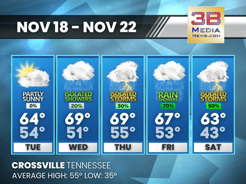
Tuesday: Partly sunny, with a high near 64. South wind 5 to 15 mph, with gusts as high as 25 mph.
Tuesday Night: Showers and thunderstorms likely. Mostly cloudy, with a low around 54. South southwest wind 5 to 10 mph, with gusts as high as 20 mph. Chance of precipitation is 70%. New precipitation amounts between a tenth and quarter of an inch, except higher amounts possible in thunderstorms.
Wednesday: A 20 percent chance of showers before 7am. Mostly cloudy, with a high near 69. West southwest wind around 5 mph.
Wednesday Night: Patchy fog after 8pm. Otherwise, mostly cloudy, with a low around 51. West northwest wind around 5 mph becoming calm.
Thursday: A slight chance of showers, then a chance of showers and thunderstorms after noon. Patchy fog before 7am. Otherwise, mostly cloudy, with a high near 69. Calm wind becoming south southwest around 5 mph. Chance of precipitation is 30%.
Thursday Night: Showers likely and possibly a thunderstorm before midnight, then a chance of showers and thunderstorms between midnight and 3am, then a chance of showers after 3am. Cloudy, with a low around 55. Calm wind becoming south southwest around 5 mph after midnight. Chance of precipitation is 60%.
Friday: Showers likely, mainly after noon. Cloudy, with a high near 67. Southwest wind around 5 mph. Chance of precipitation is 70%.
Friday Night: Showers, with thunderstorms also possible after midnight. Low around 53. Southwest wind around 5 mph. Chance of precipitation is 90%.
Saturday: A chance of showers and thunderstorms. Mostly cloudy, with a high near 63. Chance of precipitation is 50%.
Saturday Night: A 30 percent chance of showers. Mostly cloudy, with a low around 43.
Almanac for Crossville, Tennessee for November 18
- Normal High Temperature: 55
- Normal Low Temperature: 35
- Record High Temperature: 75 in 2016
- Record Low Temperature: 11 in 1959
- Record High Rainfall: 2.02 in 1957
- Record Snowfall: Trace in 1980
- Sunrise: 6:20 AM CST
- Sunset: 4:31 PM CST
- Next Full Moon: Thursday, December 4, 2025 at 5:14 PM CST (known as the Cold Moon; this full moon will also be a supermoon)
- Winter Solstice: Sunday, December 21, 2025 at 9:03 AM CST
- Daylight Saving Time Begins: Sunday, March 8, 2026 at 2:00 AM EDT
Weather information is provided by the National Weather Service in Nashville and Morristown. You can hear the latest forecast on 105.7 The Hog, 94.1 The Vibe (1410 AM), Spirit 101.9, 98.9 The Wolf, and 93.3 The Ranch (580 AM). Stay connected with Weathercaster Johnny Caudle on social media by following him on Facebook, X, Instagram, Bluesky, Mastodon, TikTok, YouTube, and Threads. You can also click here to send him an email.