
RAIN, THUNDERSTORMS TO ROLL THROUGH THURSDAY AND FRIDAY
Periods of heavy rain and scattered storms could impact your plans before skies clear for a drier, sunnier weekend.
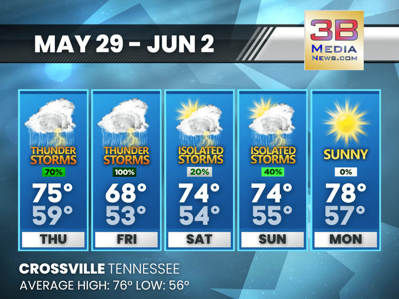
Thursday: A chance of showers and thunderstorms before 1pm, then showers likely and possibly a thunderstorm between 1pm and 3pm, then a chance of showers and thunderstorms after 3pm. Patchy fog before 8am. Otherwise, mostly cloudy, with a high near 75. Calm wind becoming west southwest around 5 mph in the afternoon. Chance of precipitation is 70%. New rainfall amounts between a tenth and quarter of an inch, except higher amounts possible in thunderstorms.
Thursday Night: A chance of showers and thunderstorms before 1am, then a slight chance of showers between 1am and 4am, then a chance of showers and thunderstorms after 4am. Mostly cloudy, with a low around 59. Calm wind becoming south southwest around 5 mph. Chance of precipitation is 30%.
Friday: Showers and possibly a thunderstorm, mainly before 1pm, then a chance of showers and thunderstorms after 1pm. High near 68. Southwest wind 5 to 10 mph becoming northwest in the afternoon. Winds could gust as high as 20 mph. Chance of precipitation is 100%.
Friday Night: A 10 percent chance of showers and thunderstorms before 7pm. Mostly clear, with a low around 53. West northwest wind 5 to 10 mph.
Saturday: A slight chance of showers between 1pm and 4pm, then a slight chance of showers and thunderstorms after 4pm. Sunny, with a high near 74. West northwest wind 5 to 10 mph, with gusts as high as 25 mph. Chance of precipitation is 20%.
Saturday Night: A slight chance of thunderstorms before 7pm. Mostly clear, with a low around 54. West northwest wind around 5 mph becoming calm in the evening. Chance of precipitation is 10%.
Sunday: A 40 percent chance of showers and thunderstorms. Mostly sunny, with a high near 74. Calm wind becoming west northwest around 5 mph in the morning.
Sunday Night: Mostly clear, with a low around 55. Calm wind.
Monday: Sunny, with a high near 78.
Monday Night: Clear, with a low around 57.
Almanac for Crossville, Tennessee for May 29, 2025:
- Normal High Temperature: 76
- Normal Low Temperature: 56
- Record High Temperature: 87 in 2019
- Record Low Temperature: 41 in 1984
- Sunrise: 5:26 AM CDT
- Sunset: 7:50 PM CDT
- Next Full Moon: Friday, June 11, 2025 at 2:44 AM CDT (known as the Strawberry Moon)
- Summer Solstice: Friday, June 20, 2025 at 9:42 PM CDT
Weather information is provided by the National Weather Service in Nashville and Morristown. Hear the latest forecast on 105.7 The Hog, 94.1 The Vibe (1410 AM), Spirit 101.9, 98.9 The Wolf, and 93.3 The Ranch (580 AM). Get connected with Weathercaster Johnny Caudle on social media. Follow him on Facebook, X, Instagram, Bluesky, and Threads. Click here to send him an email.