
SATURDAY’S 5 DAY FORECAST
A Freeze Warning is in effect for Saturday morning. A cold pattern will be in place this weekend.
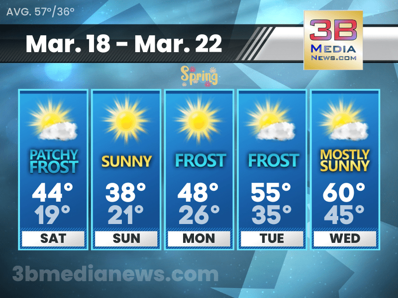
Saturday: Patchy frost before 9am. Otherwise, mostly sunny, with a high near 44. West northwest wind 10 to 15 mph, with gusts as high as 20 mph.
Saturday Night: Mostly cloudy, then gradually becoming clear, with a low around 19. North northwest wind 10 to 15 mph.
Sunday: Sunny, with a high near 38. North northwest wind around 10 mph.
Sunday Night: Mostly clear, with a low around 21. North northeast wind 5 to 10 mph.
Monday: Widespread frost before 9am. Otherwise, sunny, with a high near 48. North northeast wind around 5 mph becoming east in the afternoon.
Monday Night: Widespread frost after 3am. Otherwise, mostly clear, with a low around 26. North wind around 5 mph.
Tuesday: Widespread frost before 9am. Otherwise, mostly sunny, with a high near 55. East northeast wind around 5 mph becoming south southeast in the afternoon.
Tuesday Night: Partly cloudy, with a low around 35.
Wednesday: Mostly sunny, with a high near 60.
Wednesday Night: A 20 percent chance of showers. Mostly cloudy, with a low around 45.
Source – National Weather Service – Nashville & Morristown
Connect with Weathercaster Johnny Caudle on social media. Follow him on Facebook, Twitter, and Instagram. Send email to [email protected].