
Saturday’s 5-Day Forecast
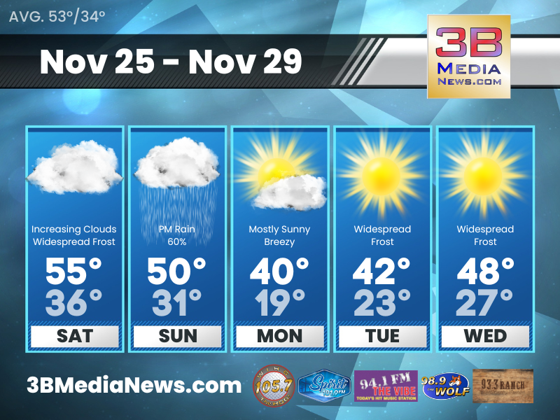
The coldest temperatures we have seen so far this season are expected on Monday and Tuesday.
Saturday: Widespread frost before 8am. Otherwise, increasing clouds, with a high near 55. East northeast wind around 5 mph becoming south in the afternoon.
Saturday Night: Patchy frost after 4am. Otherwise, mostly cloudy, then gradually becoming mostly clear, with a low around 36. South wind 5 to 10 mph.
Sunday: Rain likely, mainly after noon. Mostly cloudy, with a high near 50. South wind 10 to 15 mph. Chance of precipitation is 60%.
Sunday Night: A 50 percent chance of rain before midnight. Cloudy, with a low around 31. South southwest wind 10 to 15 mph becoming northwest after midnight. Winds could gust as high as 25 mph.
Monday: Mostly sunny, with a high near 40. Northwest wind 10 to 15 mph, with gusts as high as 20 mph.
Monday Night: Widespread frost after 11pm. Otherwise, mostly clear, with a low around 19. Northwest wind 5 to 10 mph.
Tuesday: Widespread frost before 8am. Otherwise, sunny, with a high near 42. West northwest wind 5 to 10 mph.
Tuesday Night: Widespread frost after 7pm. Otherwise, mostly clear, with a low around 23.
Wednesday: Widespread frost. Otherwise, sunny, with a high near 48.
Wednesday Night: Widespread frost. Otherwise, partly cloudy, with a low around 27.
Source: National Weather Service Weather Forecast Offices in Nashville and Morristown.
Forecaster Johnny Caudle has the latest weather forecast every hour on 105.7 The Hog, 94.1 The Vibe, Spirit 101.9, 98.9 The Wolf, and 93.3 The Ranch. Connect with Johnny Caudle on social media. Follow him on Facebook, X, Instagram and Threads. Send email to [email protected].