SEVERE THUNDERSTORM WARNING FOR FENTRESS, PICKETT

BULLETIN – IMMEDIATE BROADCAST REQUESTED
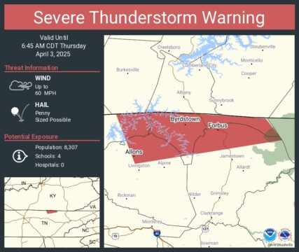
Severe Thunderstorm Warning
National Weather Service Nashville TN
6:03 AM CDT Thu Apr 3 2025
The National Weather Service in Nashville has issued a Severe Thunderstorm Warning for…Northeastern Overton County in Middle Tennessee…Pickett County in Middle Tennessee…Northeastern Clay County in Middle Tennessee…Northern Fentress County in Middle Tennessee…until 6:45 AM CDT.
At 6:02 AM CDT, a severe thunderstorm was located near Byrdstown, moving east at 60 mph.
HAZARD…60 mph wind gusts and penny size hail.
SOURCE…Radar indicated.
IMPACT…Expect damage to roofs, siding, and trees.
Locations impacted include…Wolf River Dock, Dale Hollow Lake, Pall Mall, Pickett State Park, Byrdstown, and Livingston.
PRECAUTIONARY/PREPAREDNESS ACTIONS…For your protection move to an interior room on the lowest floor of a building.
A Tornado Watch remains in effect until 8:00 AM CDT for Middle Tennessee.
HAIL THREAT…RADAR INDICATED
MAX HAIL SIZE…0.75 IN
WIND THREAT…RADAR INDICATED
MAX WIND GUST…60 MPH