SEVERE THUNDERSTORM WARNING FOR MORGAN AND ANDERSON

BULLETIN – IMMEDIATE BROADCAST REQUESTED
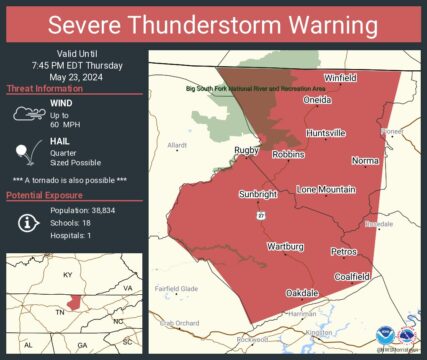
Severe Thunderstorm Warning
National Weather Service Morristown TN
638 PM EDT Thu May 23 2024
The National Weather Service in Morristown has issued a
* Severe Thunderstorm Warning for…
Morgan County in east Tennessee…
West central Anderson County in east Tennessee…
West central Campbell County in east Tennessee…
Scott County in east Tennessee…
* Until 745 PM EDT.
* At 638 PM EDT, severe thunderstorms were located along a line
extending from near Mount Pisgah to 8 miles southeast of Jamestown
to near Crossville, moving northeast at 20 mph.
HAZARD…60 mph wind gusts and quarter size hail.
SOURCE…Radar indicated.
IMPACT…Hail damage to vehicles is expected. Expect wind damage
to roofs, siding, and trees.
* Locations impacted include…
Oneida, Wartburg, Huntsville, Helenwood, Winfield, Sunbright,
Oakdale, Rugby, High Point, and Coalfield.
PRECAUTIONARY/PREPAREDNESS ACTIONS…
Remain alert for a possible tornado! Tornadoes can develop quickly
from severe thunderstorms. If you spot a tornado go at once into the
basement or small central room in a sturdy structure.
For your protection move to an interior room on the lowest floor of a
building.
Torrential rainfall is occurring with these storms, and may lead to
flash flooding. Do not drive your vehicle through flooded roadways.
TORNADO…POSSIBLE
HAIL THREAT…RADAR INDICATED
MAX HAIL SIZE…1.00 IN
WIND THREAT…RADAR INDICATED
MAX WIND GUST…60 MPH