
STORMY HOLIDAY WEEKEND TAKES OVER THE REGION
Regional Forecast — Cumberland Plateau & Tennessee Valley
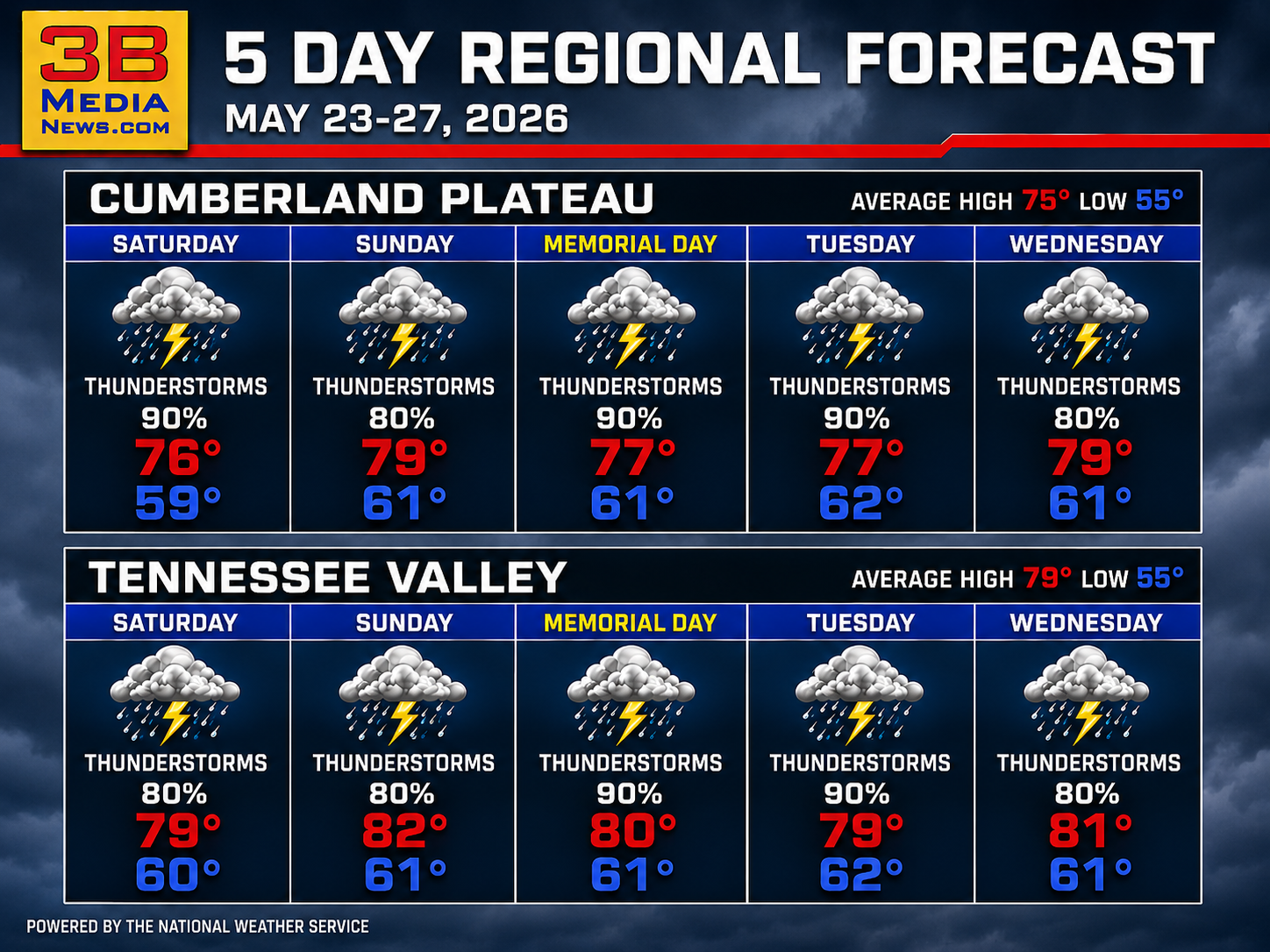
Repeated rounds of thunderstorms are expected across the region through midweek, bringing heavy rain chances and little relief from the unsettled pattern.
Saturday: Showers and possibly a thunderstorm. Additional rounds of showers and storms are expected, with a few capable of producing strong gusty winds in the Tennessee Valley. Cumberland Plateau high near 76, Tennessee Valley high near 79. South-southwest to south winds 5–10 mph with gusts up to 20 mph. Chance of precipitation: 90% Cumberland Plateau, 80% Tennessee Valley. New rainfall amounts between one-tenth and one-quarter inch in the Cumberland Plateau, and between one-quarter and one-half inch in the Tennessee Valley, with higher amounts possible in thunderstorms.
Saturday Night: Showers and thunderstorms likely during the evening, then a chance of showers overnight. Cumberland Plateau low around 59 with patchy fog between 1–4 am. Tennessee Valley low around 60. South-southwest wind around 5 mph becoming calm in the Cumberland Plateau, calm winds in the Tennessee Valley. Chance of precipitation: 60% Cumberland Plateau, 80% Tennessee Valley. New rainfall amounts between one-quarter and one-half inch possible in the Cumberland Plateau, with lighter amounts in the Tennessee Valley except higher totals in thunderstorms.
Sunday: A chance of showers in the morning, then showers and thunderstorms becoming more widespread during the afternoon. Cumberland Plateau high near 79, Tennessee Valley high near 82. Calm wind becoming south around 5 mph. Chance of precipitation 80% for both regions.
Sunday Night: Showers likely with possible thunderstorms. Cumberland Plateau low around 61 with patchy fog after 10 pm. Tennessee Valley low around 61. Mostly cloudy skies with calm winds. Chance of precipitation: 70% Cumberland Plateau, 80% Tennessee Valley.
Memorial Day (Monday): Showers likely with thunderstorms developing during the day. Cumberland Plateau high near 77, Tennessee Valley high near 80. Patchy fog before 9 am in the Cumberland Plateau. Calm wind becoming south around 5 mph in the Cumberland Plateau. Chance of precipitation 90% for both regions.
Monday Night: Showers and possibly a thunderstorm. Cumberland Plateau low around 61, Tennessee Valley low around 61. Calm winds. Chance of precipitation 80% for both regions.
Tuesday: Showers and possibly a thunderstorm. Cumberland Plateau high near 77, Tennessee Valley high near 79. Calm wind becoming south around 5 mph in the morning in the Cumberland Plateau. Chance of precipitation 90% for both regions.
Tuesday Night: Mostly cloudy with showers and thunderstorms likely early, then a chance of showers overnight. Cumberland Plateau low around 62 with south-southeast wind around 5 mph becoming calm. Tennessee Valley low around 62. Chance of precipitation: 50% Cumberland Plateau, 80% Tennessee Valley.
Wednesday: Showers and possibly a thunderstorm. Cumberland Plateau high near 79, Tennessee Valley high near 81. Chance of precipitation 80% for both regions.
Wednesday Night: Mostly cloudy with showers and thunderstorms likely. Cumberland Plateau low around 61 with a 30% chance of precipitation. Tennessee Valley low around 61 with an 80% chance of precipitation.
May 23 Almanac — Crossville & Rockwood
Temperatures
Crossville: Normal 75° / 55° | Records: 85° (2019) / 39° (1963)
Rockwood: Normal 79° / 55° | Records: 91° (1962) / 40° (1963)
Precipitation Records
Crossville: 2.66″ rain (1979) | 0.0″ snow (2000)
Rockwood: 1.99″ rain (1974) | 0.0″ snow (2025)
Sunrise & Sunset
Crossville: Sunrise 5:29 AM CDT | Sunset 7:45 PM CDT
Rockwood: Sunrise 6:26 AM EDT | Sunset 8:44 PM EDT
Sky & Seasonal Events
Next Full Moon (Blue Moon): May 31, 2026
Crossville: 3:45 AM CDT | Rockwood: 4:45 AM EDT
Summer Solstice: June 21, 2026
Crossville: 3:24 AM CDT | Rockwood: 4:24 AM EDT
Daylight Saving Time Ends: November 1, 2026
Crossville: 2:00 AM CDT | Rockwood: 2:00 AM EDT
Weather information is provided by the National Weather Service in Nashville and Morristown. You can hear the latest forecast on 105.7 The Hog, 94.1 The Vibe (1410 AM), Spirit 101.9, 98.9 The Wolf, and 93.3 The Ranch (580 AM). Stay connected with Weather Reporter Johnny Caudle on social media by following him on Facebook, X, Instagram, Bluesky, and YouTube. You can also click here to send him an email.