
SUNDAY’S 5 DAY FORECAST
The rain moves out quickly and most locations could be dry by Sunday evening.
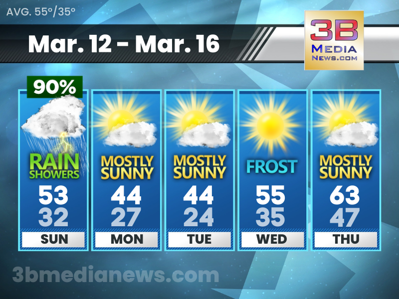
Sunday: Showers and possibly a thunderstorm before 2pm, then a chance of showers. High near 53. South wind 10 to 15 mph becoming northwest in the afternoon. Winds could gust as high as 25 mph. Chance of precipitation is 90 percent. New precipitation amounts between a tenth and quarter of an inch, except higher amounts possible in thunderstorms.
Sunday Night: Mostly cloudy, with a low around 32. Northwest wind around 10 mph, with gusts as high as 20 mph.
Monday: Mostly sunny, with a high near 44. Northwest wind 10 to 15 mph, with gusts as high as 20 mph.
Monday Night: Patchy frost after 2am. Otherwise, partly cloudy, with a low around 27. Northwest wind around 15 mph, with gusts as high as 20 mph.
Tuesday: Patchy frost before 8am. Otherwise, mostly sunny, with a high near 44. North northwest wind 10 to 15 mph, with gusts as high as 20 mph.
Tuesday Night: Widespread frost after 1am. Otherwise, mostly clear, with a low around 24. North northwest wind 5 to 10 mph.
Wednesday: Widespread frost before 8am. Otherwise, sunny, with a high near 55. North northeast wind around 5 mph becoming west northwest in the afternoon.
Wednesday Night: Mostly clear, with a low around 35.
Thursday: Mostly sunny, with a high near 63.
Thursday Night: A 20 percent chance of showers. Mostly cloudy, with a low around 47.
Source – National Weather Service – Nashville
Connect with Weathercaster Johnny Caudle on social media. Follow him on Facebook, Twitter, and Instagram. Send email to [email protected].