
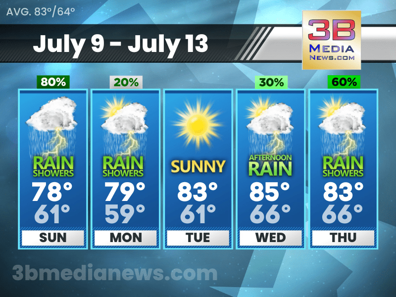
SUNDAY’S 5 DAY FORECAST
Hazardous Weather Outlook: Isolated strong to severe thunderstorms will be possible Sunday, mainly in the afternoon and evening. Some of these storms could be capable of damaging winds, hail, and localized flash flooding.
Sunday: A chance of showers and thunderstorms, then showers and possibly a thunderstorm after 7am. High near 78. West wind 5 to 10 mph. Chance of precipitation is 80%.
Sunday Night: Showers and possibly a thunderstorm before 8pm, then a chance of showers and thunderstorms, mainly between 8pm and 2am. Low around 61. West northwest wind 5 to 10 mph. Chance of precipitation is 80%.
Monday: A slight chance of showers and thunderstorms before 8am, then a slight chance of showers between 8am and 11am, then a slight chance of showers and thunderstorms after 11am. Partly sunny, with a high near 79. North wind 5 to 10 mph. Chance of precipitation is 20%.
Monday Night: A 20 percent chance of showers and thunderstorms before 8pm. Mostly clear, with a low around 59. North wind around 5 mph.
Tuesday: Sunny, with a high near 83. East northeast wind around 5 mph becoming west in the afternoon.
Tuesday Night: Mostly clear, with a low around 61. West northwest wind around 5 mph becoming east southeast after midnight.
Wednesday: A 30 percent chance of showers and thunderstorms after 2pm. Sunny, with a high near 85.
Wednesday Night: A 30 percent chance of showers and thunderstorms. Partly cloudy, with a low around 66.
Thursday: Showers and thunderstorms likely. Partly sunny, with a high near 83. Chance of precipitation is 60%.
Thursday Night: Showers and thunderstorms likely. Mostly cloudy, with a low around 66. Chance of precipitation is 60%.
Source: National Weather Service Weather Forecast Offices in Nashville and Morristown.
Forecaster Johnny Caudle has the latest weather forecast every hour on 105.7 The Hog, 94.1 The Vibe, Spirit 101.9, 98.9 The Wolf, and 93.3 The Ranch. Connect with Forecaster Johnny Caudle on social media. Follow him on Facebook, Twitter, and Instagram. Send email to [email protected].