
SUNNY SKIES AND MILD TEMPS THROUGH THE WEEKEND
Expect sunny days, calm winds, and cool nights through Sunday, with only a slight chance of showers returning Monday.
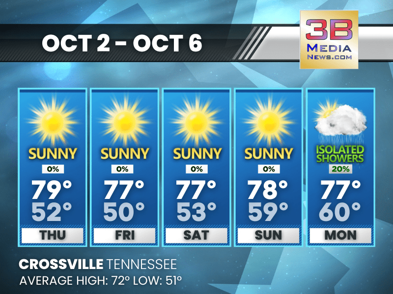
Thursday: Sunny, with a high near 79. South wind around 5 mph becoming calm in the morning.
Thursday Night: Mostly clear, with a low around 52. Calm wind becoming south around 5 mph.
Friday: Sunny, with a high near 77. Calm wind becoming east northeast around 5 mph.
Friday Night: Patchy fog after 10pm. Otherwise, mostly clear, with a low around 50. Calm wind.
Saturday: Patchy fog before 8am. Otherwise, sunny, with a high near 77. Calm wind becoming east southeast around 5 mph.
Saturday Night: Mostly clear, with a low around 53. Calm wind.
Sunday: Sunny, with a high near 78. Calm wind becoming east southeast around 5 mph in the morning.
Sunday Night: Partly cloudy, with a low around 59. Southeast wind around 5 mph.
Monday: A 20 percent chance of showers. Mostly sunny, with a high near 77.
Monday Night: A 20 percent chance of showers. Partly cloudy, with a low around 60.
Almanac for Crossville, Tennessee for October 2
- Normal High Temperature: 72
- Normal Low Temperature: 51
- Record High Temperature: 90 in 2019
- Record Low Temperature: 31 in 1974
- Record High Rainfall: 0.73 in 1961
- Sunrise: 6:36 AM CDT
- Sunset: 6:22 PM CDT
- Next Full Moon: Monday, October 6, 2025 at 10:48 PM CDT (known as the Harvest Moon; this full moon will also be a supermoon)
- Daylight Saving Time Ends: Sunday, November 2, 2025 at 2:00 AM ET
- Winter Solstice: Sunday, December 21, 2025 at 9:03 AM CST
Weather information is provided by the National Weather Service in Nashville and Morristown. You can hear the latest forecast on 105.7 The Hog, 94.1 The Vibe (1410 AM), Spirit 101.9, 98.9 The Wolf, and 93.3 The Ranch (580 AM). Stay connected with Weathercaster Johnny Caudle on social media by following him on Facebook, X, Instagram, Bluesky, and Threads. You can also click here to send him an email.