
SUNSHINE BUILDS THROUGH MIDWEEK BEFORE STORMS RETURN
Dry and pleasant through Thursday, then increasing rain and thunder chances Friday into Friday night.
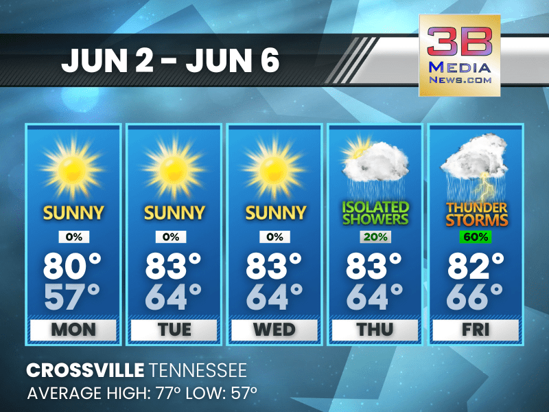
Monday: Patchy fog before 8am. Otherwise, sunny, with a high near 80. Calm wind.
Monday Night: Mostly clear, with a low around 57. Calm wind.
Tuesday: Sunny, with a high near 83. Light south southeast wind becoming south 5 to 10 mph in the morning.
Tuesday Night: Mostly clear, with a low around 64. South southeast wind around 5 mph.
Wednesday: Sunny, with a high near 83. South wind 5 to 10 mph.
Wednesday Night: Partly cloudy, with a low around 64. South wind around 5 mph.
Thursday: A 20 percent chance of showers after 1pm. Mostly sunny, with a high near 84. South wind around 5 mph.
Thursday Night: A 20 percent chance of showers and thunderstorms. Mostly cloudy, with a low around 65. South wind around 5 mph becoming calm.
Friday: A chance of showers and thunderstorms, then showers likely and possibly a thunderstorm after 1pm. Mostly cloudy, with a high near 82. Chance of precipitation is 60%.
Friday Night: Showers and thunderstorms likely. Mostly cloudy, with a low around 66. Chance of precipitation is 60%.
Almanac for Crossville, Tennessee for June 2, 2025:
- Normal High Temperature: 77
- Normal Low Temperature: 57
- Record High Temperature: 87 in 2011
- Record Low Temperature: 38 in 1956
- Sunrise: 5:25 AM CDT
- Sunset: 7:52 PM CDT
- Next Full Moon: Friday, June 11, 2025 at 2:44 AM CDT (known as the Strawberry Moon)
- Summer Solstice: Friday, June 20, 2025 at 9:42 PM CDT
Weather information is provided by the National Weather Service in Nashville and Morristown. Hear the latest forecast on 105.7 The Hog, 94.1 The Vibe (1410 AM), Spirit 101.9, 98.9 The Wolf, and 93.3 The Ranch (580 AM). Get connected with Weathercaster Johnny Caudle on social media. Follow him on Facebook, X, Instagram, Bluesky, and Threads. Click here to send him an email.