
TRIPLE-DIGIT HEAT INDEX VALUES TO BAKE THE REGION THIS WEEK
Oppressive heat builds through midweek with limited rain chances and only isolated storms.
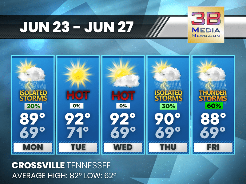
Monday: A slight chance of showers and thunderstorms between noon and 1pm. Patchy fog before 8am. Otherwise, sunny, with a high near 89. Calm wind. Chance of precipitation is 20%.
Monday Night: Areas of fog after 4am. Otherwise, mostly clear, with a low around 69. Calm wind.
Tuesday: Sunny, with a high near 92. Heat index values as high as 97. Calm wind.
Tuesday Night: Mostly clear, with a low around 71. Calm wind.
Wednesday: Mostly sunny, with a high near 92. Calm wind.
Wednesday Night: Partly cloudy, with a low around 69. Calm wind.
Thursday: A 30 percent chance of showers and thunderstorms after 1pm. Mostly sunny, with a high near 90. Calm wind becoming north around 5 mph.
Thursday Night: A slight chance of showers and thunderstorms. Partly cloudy, with a low around 69. Calm wind. Chance of precipitation is 20%.
Friday: Showers and thunderstorms likely, mainly after 1pm. Mostly sunny, with a high near 88. Chance of precipitation is 60%.
Friday Night: A 30 percent chance of showers and thunderstorms. Partly cloudy, with a low around 69.
Almanac for Crossville, Tennessee for June 23, 2025:
- Normal High Temperature: 82
- Normal Low Temperature: 62
- Record High Temperature: 96 in 1988
- Record Low Temperature: 47 in 1992
- Sunrise: 5:25 AM CDT
- Sunset: 8:01 PM CDT
- Next Full Moon: Thursday, July 10, 2025 at 4:37 PM CDT (known as the Buck Moon)
- Autumn Equinox: Monday, September 22, 2025 at 1:19 PM CDT
Weather information is provided by the National Weather Service in Nashville and Morristown. Hear the latest forecast on 105.7 The Hog, 94.1 The Vibe (1410 AM), Spirit 101.9, 98.9 The Wolf, and 93.3 The Ranch (580 AM). Get connected with Weathercaster Johnny Caudle on social media. Follow him on Facebook, X, Instagram, Bluesky, and Threads. Click here to send him an email.