
TUESDAY’S 5 DAY FORECAST
Frost Advisories and Freeze Warnings are in effect across the area for Tuesday morning.
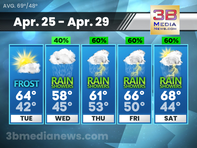
Tuesday: Widespread frost, mainly before 7am. Otherwise, mostly cloudy, then gradually becoming sunny, with a high near 64. East wind around 5 mph.
Tuesday Night: A 10 percent chance of showers after 5am. Increasing clouds, with a low around 42. East northeast wind around 5 mph.
Wednesday: A 40 percent chance of showers. Mostly cloudy, with a high near 58. East wind around 5 mph.
Wednesday Night: A 40 percent chance of showers, mainly after 1am. Mostly cloudy, with a low around 45. East wind around 5 mph.
Thursday: A chance of showers, then showers likely and possibly a thunderstorm after 1pm. Cloudy, with a high near 61. East southeast wind 10 to 15 mph. Chance of precipitation is 60%.
Thursday Night: Showers likely and possibly a thunderstorm. Mostly cloudy, with a low around 53. South southeast wind around 10 mph. Chance of precipitation is 70%.
Friday: Showers likely, with thunderstorms also possible after 1pm. Mostly cloudy, with a high near 66. West southwest wind around 10 mph. Chance of precipitation is 60%.
Friday Night: A 20 percent chance of showers. Partly cloudy, with a low around 50. West wind 5 to 10 mph.
Saturday: A chance of showers, then showers likely and possibly a thunderstorm after 1pm. Partly sunny, with a high near 68. Chance of precipitation is 60%.
Saturday Night: A 40 percent chance of showers and thunderstorms. Mostly cloudy, with a low around 44.
Source – National Weather Service – Nashville, Morristown, Jackson & Louisville
Connect with Forecaster Johnny Caudle on social media. Follow him on Facebook, Twitter, and Instagram. Send email to [email protected].