
WEDNESDAY’S 5 DAY FORECAST
Rain showers should become focused east on I-65 by early Wednesday morning and gradually come to an end along the Plateau by early afternoon.
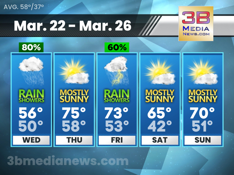
Wednesday: Showers, mainly before 2pm. High near 56. South wind 10 to 15 mph, with gusts as high as 20 mph. Chance of precipitation is 80 percent.
Wednesday Night: Mostly cloudy, with a low around 50. South wind 10 to 15 mph, with gusts as high as 20 mph.
Thursday: Mostly sunny, with a high near 75. South wind around 15 mph, with gusts as high as 25 mph.
Thursday Night: Partly cloudy, with a low around 58. South southwest wind around 15 mph, with gusts as high as 20 mph.
Friday: A chance of showers, then showers likely and possibly a thunderstorm after 1pm. Mostly cloudy, with a high near 73. South southwest wind 15 to 20 mph, with gusts as high as 25 mph. Chance of precipitation is 60 percent.
Friday Night: Showers and possibly a thunderstorm. Low around 53. South wind 15 to 20 mph, with gusts as high as 25 mph. Chance of precipitation is 90 percent.
Saturday: Mostly sunny, with a high near 65.
Saturday Night: Mostly clear, with a low around 42.
Sunday: Mostly sunny, with a high near 70.
Sunday Night: Showers likely and possibly a thunderstorm. Mostly cloudy, with a low around 51. Chance of precipitation is 60 percent.
Source – National Weather Service – Nashville
Connect with Weathercaster Johnny Caudle on social media. Follow him on Facebook, Twitter, and Instagram. Send email to [email protected].