
WINTRY MIX AND ICE THIS WEEKEND, SHARP COLD TO FOLLOW
Sleet and freezing rain Saturday transition to rain Sunday, followed by a sharp turn colder that persists into midweek.
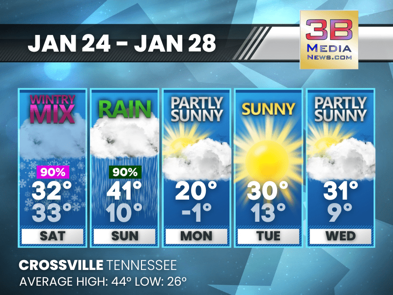
Saturday: Sleet, possibly mixed with snow before 5pm, then freezing rain and sleet. The sleet could be heavy at times. High near 32. East northeast wind around 5 mph. Chance of precipitation is 90%. Little or no ice accumulation expected. New snow and sleet accumulation of around an inch possible.
Saturday Night: Freezing rain, possibly mixed with sleet before 3am, then rain or freezing rain between 3am and 4am, then rain after 4am. Temperature rising to around 33 by 4am. East wind 5 to 10 mph becoming south southeast after midnight. Winds could gust as high as 20 mph. Chance of precipitation is 100%. New ice accumulation of 0.2 to 0.4 of an inch possible. Little or no sleet accumulation expected.
Sunday: Rain. High near 41. South southeast wind around 10 mph becoming west in the afternoon. Winds could gust as high as 25 mph. Chance of precipitation is 100%.
Sunday Night: A chance of rain or freezing rain before 9pm, then a chance of snow between 9pm and midnight. Mostly cloudy, with a low around 10. West northwest wind around 10 mph, with gusts as high as 25 mph. Chance of precipitation is 40%.
Monday: Partly sunny, with a high near 20. Northwest wind around 10 mph, with gusts as high as 25 mph.
Monday Night: Partly cloudy, with a low around -1. West northwest wind 5 to 10 mph becoming southwest after midnight. Winds could gust as high as 20 mph.
Tuesday: Sunny, with a high near 30. West southwest wind 5 to 10 mph, with gusts as high as 25 mph.
Tuesday Night: Mostly clear, with a low around 13. West wind around 5 mph.
Wednesday: Partly sunny, with a high near 31.
Wednesday Night: A 20 percent chance of snow. Mostly cloudy, with a low around 9.
Almanac for Crossville, Tennessee for January 24
- Normal High Temperature: 44
- Normal Low Temperature: 26
- Record High Temperature: 68 in 1967
- Record Low Temperature: -16 in 1963
- Record Rainfall: 2.15 in 2010
- Record Snowfall: 6.0 in 1977
- Sunrise: 6:46 AM CST
- Sunset: 4:59 PM CST
- Next Full Moon: Sunday, February 1, 2026 at 5:09 AM CST (known as the Snow Moon)
- Daylight Saving Time Begins: Sunday, March 8, 2026 at 2:00 AM EDT
- Spring Equinox: Friday, March 20, 2026 at 9:46 AM CST
Weather information is provided by the National Weather Service in Nashville and Morristown. You can hear the latest forecast on 105.7 The Hog, 94.1 The Vibe (1410 AM), Spirit 101.9, 98.9 The Wolf, and 93.3 The Ranch (580 AM). Stay connected with Weather Reporter Johnny Caudle on social media by following him on Facebook, X, Instagram, Bluesky, Mastodon, TikTok, YouTube, and Threads. You can also click here to send him an email.