
COOL START TO THE WEEK WITH PATCHY FOG AND SCATTERED SHOWERS
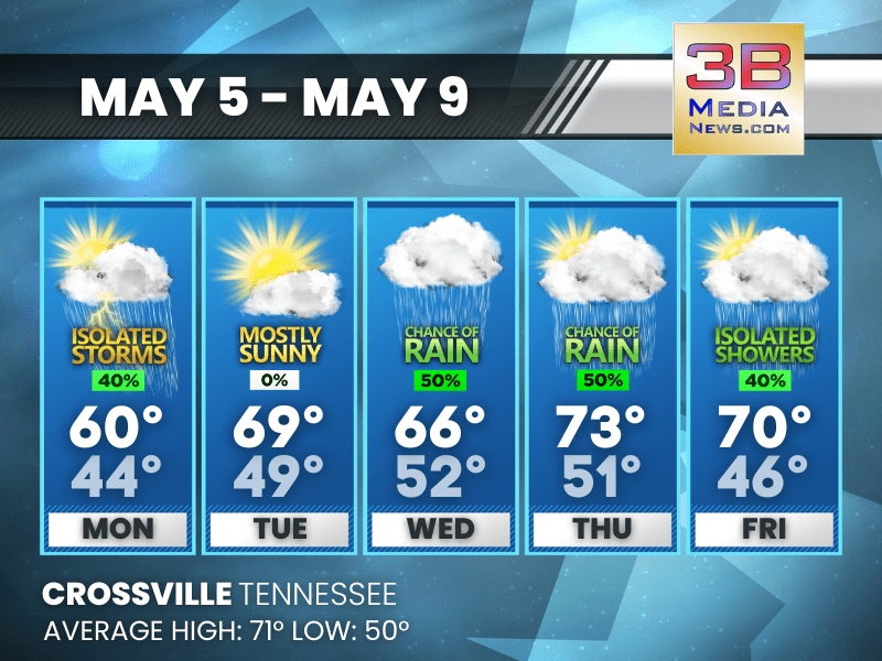
Monday: A chance of showers and thunderstorms. Patchy fog before 9am. Otherwise, partly sunny, with a high near 60. West southwest wind 5 to 10 mph. Chance of precipitation is 40%.
Monday Night: Patchy fog before 4am, then patchy fog after 5am. Otherwise, partly cloudy, with a low around 44. West southwest wind around 5 mph becoming calm.
Tuesday: Patchy fog before 7am. Otherwise, mostly sunny, with a high near 69. Calm wind becoming west around 5 mph in the morning.
Tuesday Night: Mostly cloudy, with a low around 49. Calm wind.
Wednesday: A 50 percent chance of showers. Mostly cloudy, with a high near 66. Calm wind becoming south around 5 mph.
Wednesday Night: A 40 percent chance of showers. Mostly cloudy, with a low around 52. Calm wind.
Thursday: A 50 percent chance of showers, mainly after 1pm. Partly sunny, with a high near 73. Calm wind becoming north northeast around 5 mph in the afternoon.
Thursday Night: A 20 percent chance of showers. Mostly cloudy, with a low around 51. North northeast wind around 5 mph.
Friday: A 40 percent chance of showers. Mostly sunny, with a high near 70.
Friday Night: A 20 percent chance of showers. Partly cloudy, with a low around 46.
Almanac for Crossville, Tennessee for May 5, 2025:
- Normal High Temperature: 71
- Normal Low Temperature: 50
- Record High Temperature: 86 in 1959
- Record Low Temperature: 29 in 1954
- Sunrise: 5:43 AM CDT
- Sunset: 7:31 PM CDT
- Next Full Moon: Monday, May 12, 2025 at 11:56 AM CDT (known as the Flower Moon)
- Summer Solstice: Friday, June 20, 2025 at 9:42 PM CDT
Weather information is provided by the National Weather Service in Nashville and Morristown. Hear the latest forecast on 105.7 The Hog, 94.1 The Vibe (1410 AM), Spirit 101.9, 98.9 The Wolf, and 93.3 The Ranch (580 AM). Get connected with Weathercaster Johnny Caudle on social media. Follow him on Facebook, X, Instagram, Bluesky, and Threads. Click here to send him an email.