
SPRING WARMTH BUILDS WITH A SUNNY WEEKEND PEAK
Temperatures trend above average with increasing sunshine, peaking near 80 before a cooler start to next week.
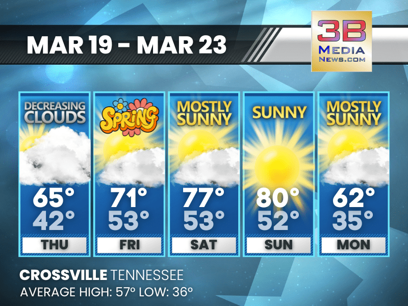
Thursday: Mostly cloudy, then gradually becoming sunny, with a high near 65. West southwest wind around 5 mph.
Thursday Night: Mostly clear, with a low around 42. Calm wind.
Friday: Mostly sunny, with a high near 71. South southwest wind 5 to 10 mph, with gusts as high as 20 mph.
Friday Night: Mostly cloudy, with a low around 53. West southwest wind around 5 mph.
Saturday: A chance of sprinkles after 1pm. Mostly sunny, with a high near 77. West wind around 5 mph.
Saturday Night: Mostly clear, with a low around 53. West southwest wind around 5 mph becoming calm.
Sunday: Sunny, with a high near 80. Southwest wind 5 to 10 mph, with gusts as high as 20 mph.
Sunday Night: A 20 percent chance of showers after 1am. Mostly clear, with a low around 52. Southwest wind 5 to 10 mph, with gusts as high as 20 mph.
Monday: Mostly sunny, with a high near 62.
Monday Night: Mostly clear, with a low around 35.
Almanac for Crossville, Tennessee for March 19
- Normal High Temperature: 57
- Normal Low Temperature: 36
- Record High Temperature: 80 in 1982
- Record Low Temperature: 18 in 2023
- Record Rainfall: 1.38 in 2000
- Record Snowfall: 3.0 in 1996
- Sunrise: 6:45 AM CDT
- Sunset: 6:51 PM CDT
- Spring Equinox: Friday, March 20, 2026 at 9:46 AM CST
- Next Full Moon: Wednesday, April 1, 2026 at 9:12 PM CST (known as the Pink Moon)
- Daylight Saving Time Ends: Sunday, November 1, 2026 at 2:00 AM CDT
Weather information is provided by the National Weather Service in Nashville and Morristown. You can hear the latest forecast on 105.7 The Hog, 94.1 The Vibe (1410 AM), Spirit 101.9, 98.9 The Wolf, and 93.3 The Ranch (580 AM). Stay connected with Weather Reporter Johnny Caudle on social media by following him on Facebook, X, Instagram, Bluesky, and YouTube. You can also click here to send him an email.