
STORMY PATTERN HOLDS ACROSS THE REGION
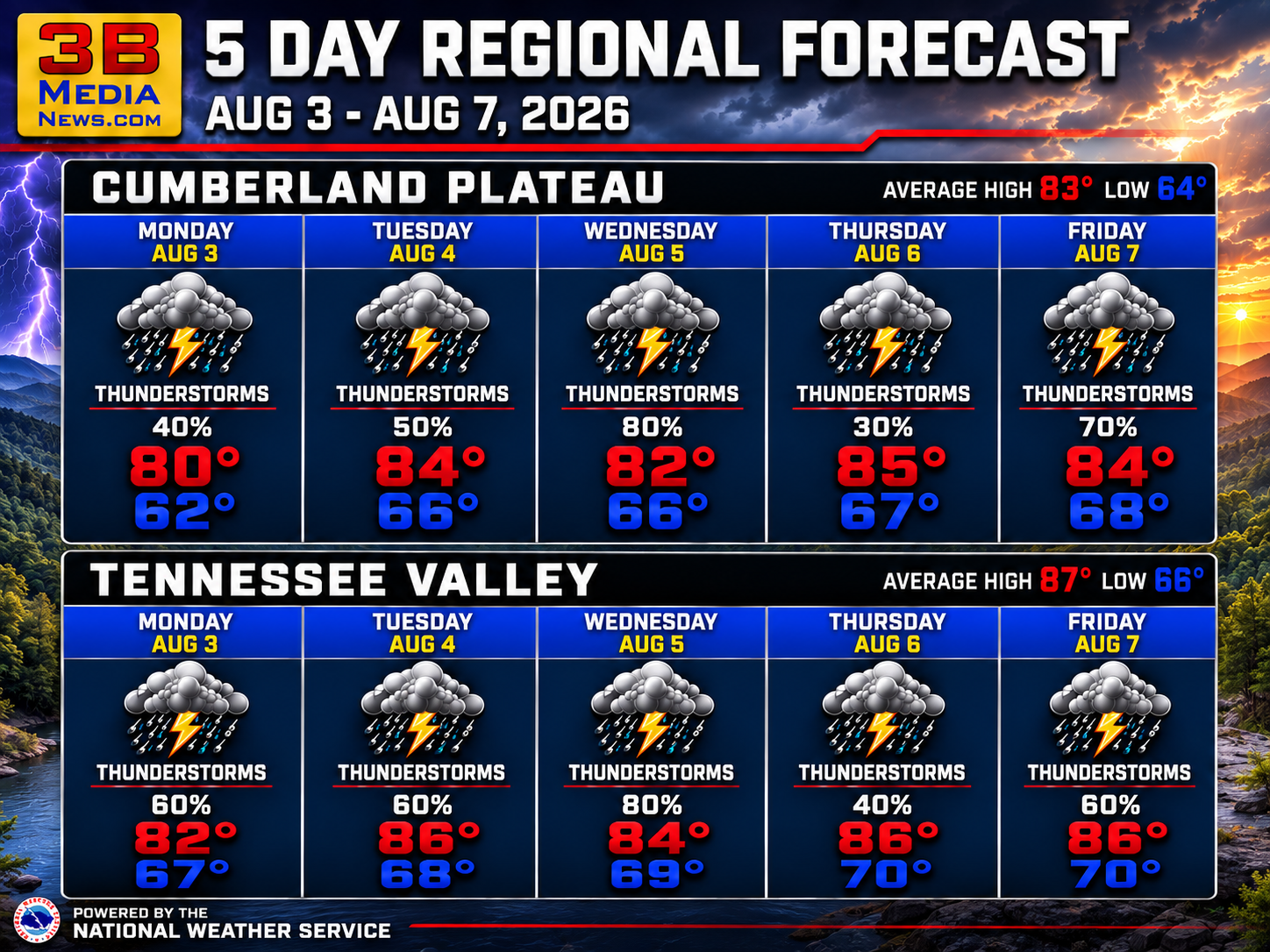
Regional Forecast — Cumberland Plateau & Tennessee Valley
A typical summertime pattern continues through the week with warm, humid afternoons and daily chances for showers and thunderstorms. The greatest coverage of rain is expected from Tuesday through Saturday, mainly during the afternoon and evening.
Monday: Patchy morning fog, then partly sunny with scattered showers and thunderstorms developing during the day. Highs in the upper 70s to lower 80s. Chance of rain 50 percent.
Monday Night: Partly cloudy to mostly cloudy with patchy late-night fog. Lows in the mid to upper 60s.
Tuesday: Mostly sunny during the morning, then showers and thunderstorms become likely during the afternoon. Highs in the lower to mid 80s. Chance of rain 60 to 70 percent.
Tuesday Night: A slight chance of evening showers and thunderstorms, then areas of fog developing overnight. Lows in the upper 60s. Chance of rain 20 percent.
Wednesday: Patchy morning fog, then showers and thunderstorms likely, especially during the afternoon. Highs in the lower to mid 80s. Chance of rain 70 percent.
Wednesday Night: Partly cloudy. Lows in the upper 60s to around 70. Chance of rain 20 percent.
Thursday: Mostly sunny with scattered afternoon showers and thunderstorms. Highs in the mid to upper 80s. Chance of rain 40 to 50 percent.
Thursday Night: Partly cloudy. Lows in the upper 60s to around 70. Chance of rain 20 percent.
Friday: Mostly sunny with showers and thunderstorms becoming more numerous during the afternoon. Highs in the mid to upper 80s. Chance of rain 50 to 70 percent.
Friday Night: Partly cloudy. Lows in the upper 60s to around 70. Chance of rain 20 percent.
Saturday: Mostly sunny with showers and thunderstorms likely during the afternoon. Highs in the mid to upper 80s. Chance of rain 70 percent.
Saturday Night: Partly cloudy. Lows in the upper 60s to around 70. Chance of rain 20 percent.
Sunday: Mostly sunny with scattered afternoon showers and thunderstorms. Highs in the mid to upper 80s. Chance of rain 50 percent.
August 3 Almanac — Crossville & Rockwood
Temperatures
Crossville: Normal 83° / 64° | Records: 93° (1987) / 52° (1965)
Rockwood: Normal 87° / 66° | Records: 95° (1980) / 52° (1976)
Precipitation Records
Crossville: 0.81″ rain (1988) | 0.0″ snow (2010)
Rockwood: 1.74″ rain (1950) | 0.0″ snow (2025)
Sunrise & Sunset
Crossville: Sunrise 5:49 AM CDT | Sunset 7:43 PM CDT
Rockwood: Sunrise 6:46 AM EDT | Sunset 8:43 PM EDT
Sky & Seasonal Events
Next Full Moon (Sturgeon Moon): August 27–28, 2026
Crossville: 11:18 PM CDT (Aug. 27) | Rockwood: 12:18 AM EDT (Aug. 28)
Autumn Equinox: September 22, 2026
Crossville: 7:05 PM CDT | Rockwood: 8:05 PM EDT
Daylight Saving Time Ends: November 1, 2026
Crossville: 2:00 AM CDT | Rockwood: 2:00 AM EDT
Weather information is provided by the National Weather Service in Nashville and Morristown. You can hear the latest forecast on 105.7 The Hog, 94.1 The Vibe (1410 AM), Spirit 101.9, 98.9 The Wolf, and 93.3 The Ranch (580 AM). Stay connected with Weathercaster Johnny Caudle on social media by following him on Facebook, X, Instagram, Bluesky, and YouTube. You can also click here to send him an email.
