ALBERTO DRENCHES GULF COAST, INLAND FLOODING IS NOW THE FOCUS
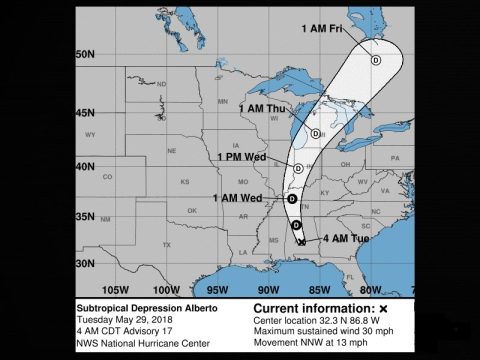
Millions of people in the South are waking up in the middle of a powerful storm. Alberto made landfall along the Florida Panhandle as a subtropical storm yesterday. Some areas got more than four inches of rain in 24 hours. Wind gusts of around 50 miles an hour knocked down trees and created large waves. The system is moving north, threatening Alabama, Tennessee, Kentucky, and North Carolina with heavy rain Tuesday.
At its height, tropical storm-force winds extended 90 miles from Alberto’s core. The violent storm upended trees, brought down power lines and sent water from crashing waves spilling onto roads.
Within hours, one home was surrounded by water – showing the powerful effects of the storm’s rain in such a short time. Empty beaches along the Florida Panhandle were standard throughout the holiday weekend. But the dangerous surf didn’t stop a few dare-devil surfers from catching a last-minute wave.
“Until you get out past the breakers, it’s like being in a washing machine. You get one good ride and it’s worth it,” Kyle Buck said.
But most beachgoers heeded the warnings and steered clear of the water, fearing dangerous rip currents. On the Atlantic Coast, the storm spawned tornadoes. One briefly touched down in the town of Stuart – destroying Peter Hill’s trees, car and power line.
As the storm leaves the Gulf Coast, local threats of rip currents remain. Inland flooding is now the focus as Alberto becomes a tropical depression. While most people there are thankful the storm’s impact wasn’t catastrophic, hurricane season still doesn’t officially begin for another three days.


