

WEEK AHEAD: MIXED WEATHER WITH PATCHY FOG, SHOWERS, AND THUNDERSTORMS EXPECTED
Good news is any thunderstorms through the next couple of days will pose little risk for severe weather. Brief downpours and lightning will be the main concerns. Monday: A 20 percent chance of shower ...

UNSETTLED WEEK AHEAD: SHOWERS, THUNDERSTORMS EXPECTED STARTING SUNDAY
Nearly daily showers and thunderstorms are expected with the best coverage on Wednesday. Sunday: Showers likely and possibly a thunderstorm before 8am, then a chance of showers and thunderstorms afte ...

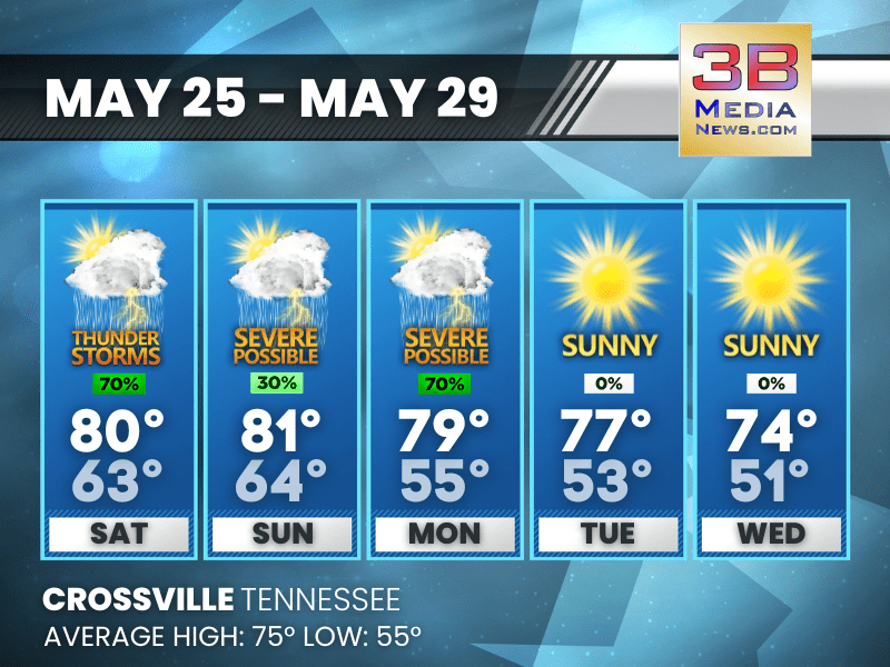
SUNNY SKIES ON THURSDAY AND FRIDAY, RAIN AND THUNDERSTORMS EXPECTED OVER THE WEEKEND
Thursday: Sunny, with a high near 74. Calm wind becoming north around 5 mph in the afternoon. Thursday Night: Mostly clear, with a low around 50. North northeast wind around 5 mph becoming calm. ...
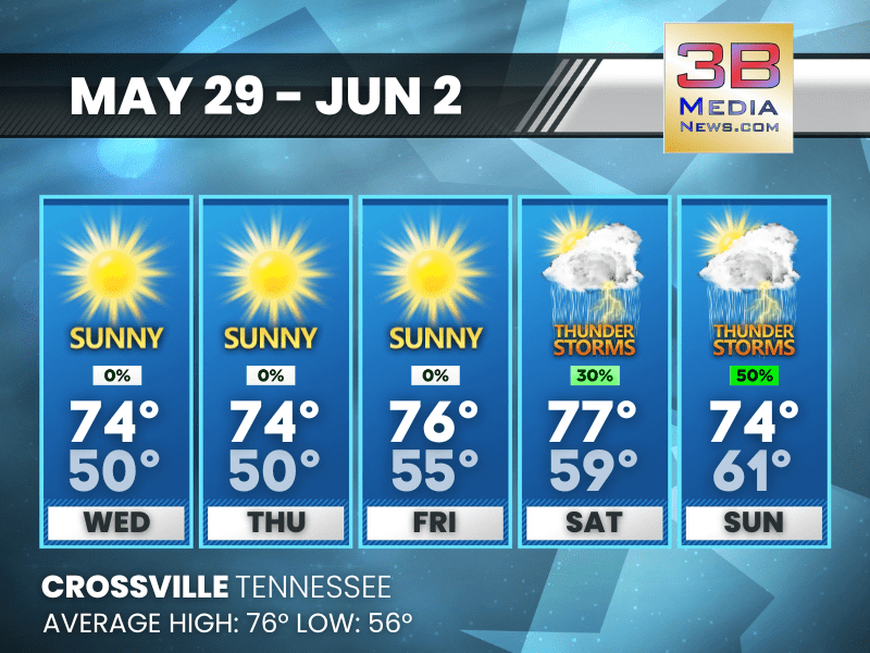
SUNNY MIDWEEK, CHANCE OF SHOWERS AND THUNDERSTORMS BY WEEKEND
Here's your weather forecast for the next five days: Wednesday: Sunny, with a high near 74. Light west wind becoming west northwest 5 to 10 mph in the morning. Winds could gust as high as 20 mph. ...

STATE OF EMERGENCY DECLEARED IN KENTUCKY
A State of Emergency has been declared in Kentucky as a result of severe weather across the Bluegrass State. “Severe weather continues to move through the commonwealth with multiple reports of wind ...

TORNADO WATCH IN EFFECT OVERNIGHT
The National Weather Service has issued a Tornado Watch for Cumberland County, Pickett County, Fentress County, Blount County, Morgan County, Rhea County, Meigs County, Monroe County, Roane County, Lo ...

MEMORIAL DAY WEATHER: SHOWERS, THUNDERSTORMS, AND HEAVY RAIN EXPECTED BEFORE NOON
Another round of showers and thunderstorms are possible on Monday. Drier and cooler weather to begin Tuesday through the end of the week with a gradual warming trend into the weekend. Memorial Day: S ...

TORNADO WATCH ISSUED FOR MIDDLE AND EAST TENNESSEE
The National Weather Service has issued a Tornado Watch for Cumberland County, Fentress County, Pickett County, Blount County, Morgan County, Roane County, Loudon County, and Anderson County in the 3B ...

NATIONAL WEATHER SERVICE WARNS OF POTENTIAL SEVERE THUNDERSTORMS TODAY AND TONIGHT
MIDDLE TENNESSEE The National Weather Service in Nashville continues to monitor the potential for strong to severe thunderstorms today and tonight. Some activity is possible later this morning as a ...

FLOOD WATCH ISSUED FOR THE UPPER CUMBERLAND
The National Weather Service has issued a Flood Watch for a portion of Middle Tennessee, including Cumberland County, Fentress County, and Pickett County in the 3B Media News coverage area, from 7 AM ...

SEVERE WEATHER THREAT: MIDDLE AND EAST TENNESSEE BRACES FOR DAMAGING WINDS AND LARGE HAIL ON SUNDAY
Sunday is shaping up to be quite eventful for Middle and East Tennessee. All forms of severe weather are possible, with the primary hazards being damaging winds exceeding 60 mph and large hail. Tornad ...
WEEKEND WEATHER FORECAST: THUNDERSTORMS AND SHOWERS LIKELY, CLEARING BY MIDWEEK
Hazardous Weather Outlook: Isolated to scattered showers and storms are expected this morning, activity will be more isolated this afternoon and evening. A few storms may be strong, with gusty winds a ...