
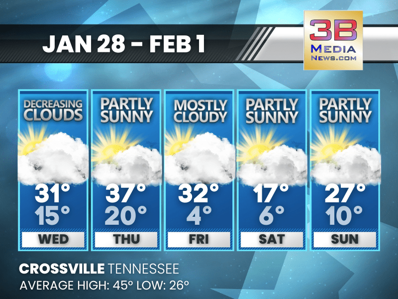
BITTER COLD SNAP DOMINATES LATE WEEK AND WEEKEND
Temperatures tumble late week, with the coldest air arriving Saturday before a slow rebound. Wednesday: Mostly cloudy through mid morning, then gradual clearing, with a high near 31. West northwest ...
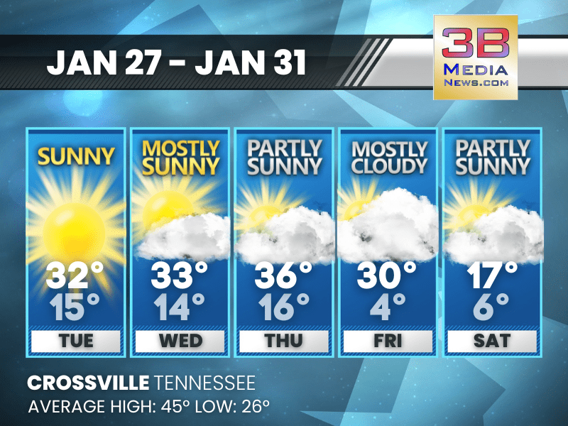
BRIGHT SKIES, BITTER COLD SET THE TONE
A mostly dry stretch brings plenty of sunshine, but temperatures stay well below normal and turn sharply colder late in the week. Tuesday: Sunny, with a high near 32. Wind chill values as low as -4 ...
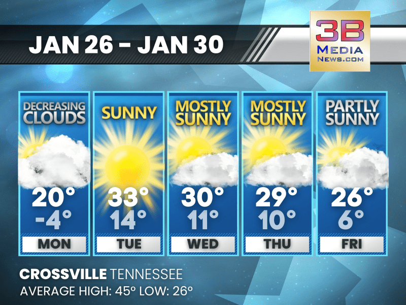
COLD, BRIGHT, AND STAYING BELOW NORMAL ALL WEEK
A stretch of sunshine dominates the forecast, but persistent cold keeps temperatures well below average through the end of the week. Monday: Cloudy through mid morning, then gradual clearing, with ...

EXTREME COLD GRIPS THE REGION
The National Weather Service has issued multiple cold weather alerts across parts of the region, warning of dangerously low wind chills through early Tuesday. In Middle Tennessee, a Cold Weather Advis ...
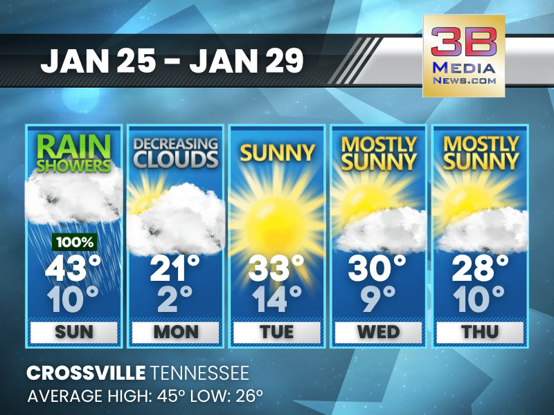
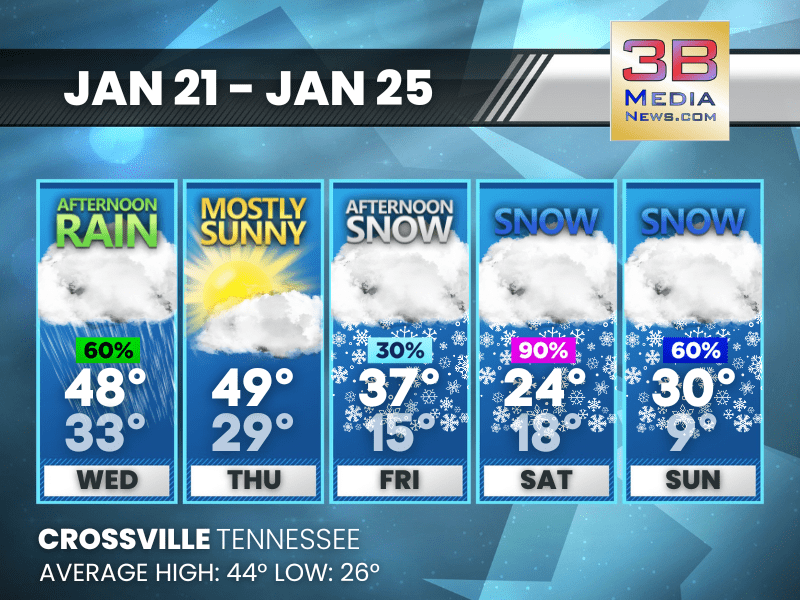
RAIN, WIND, THEN A DEEP FREEZE INTO MIDWEEK
Rain and gusty winds end Sunday afternoon before much colder air settles in, bringing hard freezes and well-below-normal temperatures through midweek. Sunday: Showers, mainly before 3pm. High near ...
WINTRY MIX AND ICE THIS WEEKEND, SHARP COLD TO FOLLOW
Sleet and freezing rain Saturday transition to rain Sunday, followed by a sharp turn colder that persists into midweek. Saturday: Sleet, possibly mixed with snow before 5pm, then freezing rain and ...

WINTER STORM TARGETS TENNESSEE THIS WEEKEND
A complex winter storm is expected to affect much of Tennessee, southwest North Carolina, and parts of southwest Virginia this weekend, according to the National Weather Service. Conditions will begin ...

WINTER STORM ALERT
The National Weather Service has issued a Winter Storm Warning for a portion of Middle Tennessee, beginning at midnight Friday night and continuing through 6 p.m. Sunday, as a powerful and potentially ...
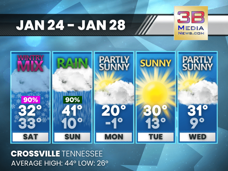
WINTRY MIX THIS WEEKEND, SHARP COLD TO FOLLOW
Snow, sleet, and freezing rain arrive Saturday into Sunday before bitter cold settles in early next week. Friday: Cloudy, then gradually becoming mostly sunny, with a high near 40. North wind 5 to ...
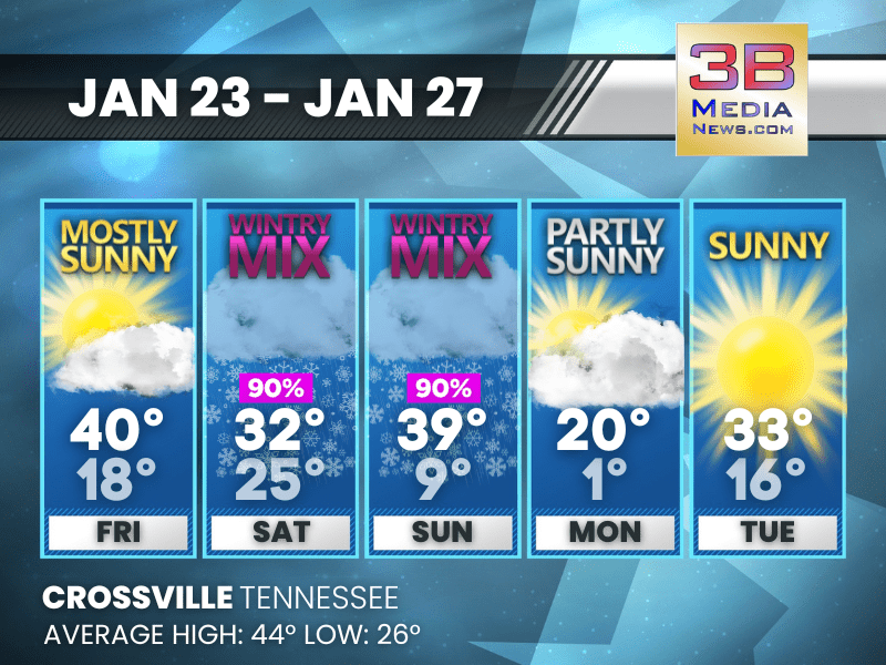
WINTRY MIX THREAT BUILDS INTO THE WEEKEND
After a quiet and mild Thursday, colder air arrives Friday with snow chances increasing into a prolonged period of snow, sleet, and freezing rain through Sunday before colder, drier weather returns. ...

WINTER STORM WATCH ISSUED FOR THE CUMBERLAND PLATEAU
The National Weather Service has issued a Winter Storm Watch from Friday evening through Sunday afternoon for Cumberland, Pickett, and Fentress counties. Forecasters say the system could bring heavy s ...
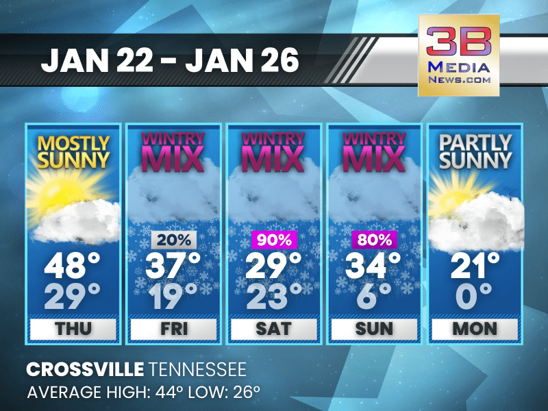
WINTRY BLAST SET TO TAKE OVER THIS WEEKEND
A quiet stretch through Thursday gives way to a sharp turn toward accumulating snow and bitter cold from Friday afternoon through Sunday. Wednesday: Rain likely, mainly after 5pm. Increasing clouds ...