

Thursday’s 5-Day Forecast
Much needed rainfall is on the way! Still forecasted to arrive on Thursday and spread across the area Thursday night and Friday, this slow-moving frontal boundary should provide us with an average of ...

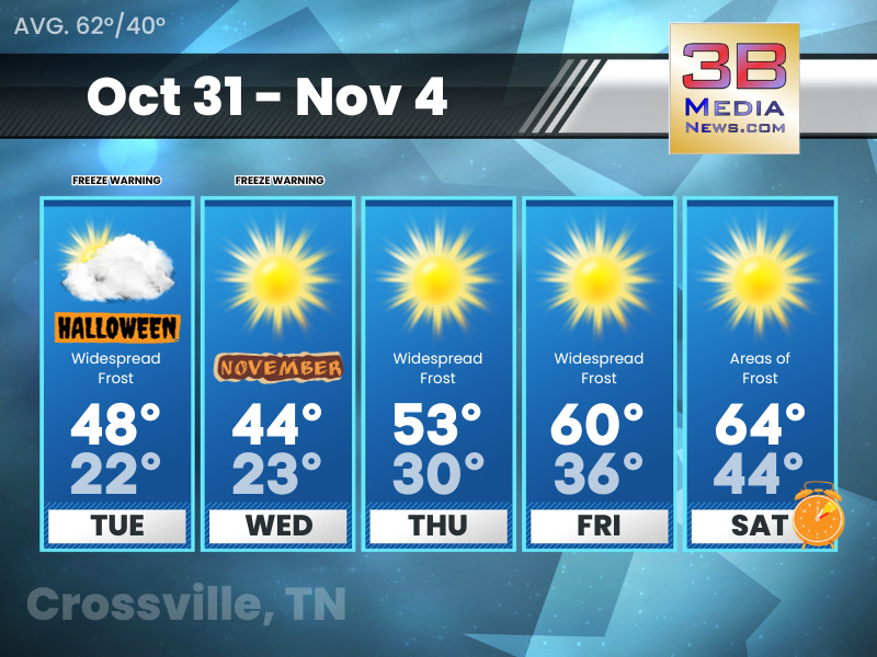
Wednesday’s 5-Day Forecast
Thursday and Friday continue to be the main focus for rainfall this week. We're only expecting showers with this system, but don't be surprised to hear a rumble of thunder at some point Thursday night ...

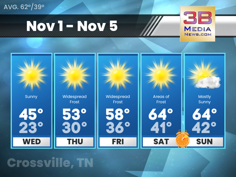
Tuesday’s 5-Day Forecast
Dry, warm above normal temperatures, and mostly clear skies with increasing southwest winds. Tuesday: Sunny, with a high near 75. West southwest wind 5 to 10 mph. Tuesday Night: Mostly clear, with a ...

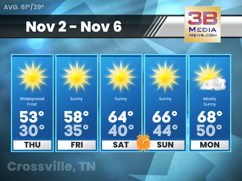
Monday’s 5-Day Forecast
Dry weather continues through at least Wednesday. Rain chances return Thursday into Friday with a cold front. Well above normal temperatures midweek, with worsening drought conditions. Monday: Sunny, ...
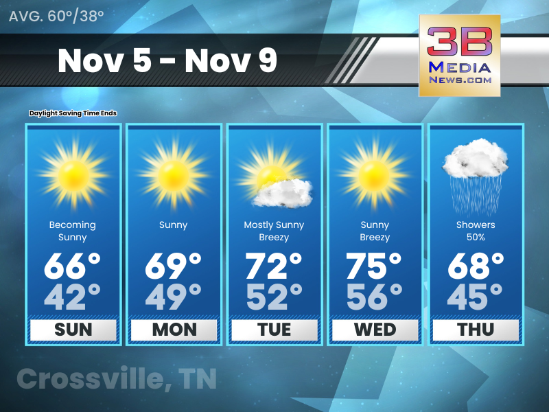
Sunday’s 5-Day Forecast
With Daylight Saving Time ending, sunrise Sunday in Crossville will be at 6:06 AM Central and sunset Sunday will be at 4:40 PM Central. Sunday: Partly sunny, then gradually becoming sunny, with a hig ...

Saturday’s 5-Day Forecast
Saturday: Sunny, with a high near 64. West southwest wind 5 to 10 mph. Saturday Night: Mostly cloudy, with a low around 41. Southwest wind around 5 mph. Sunday: Sunny, with a high near 65. Northwest ...

Friday’s 5-Day Forecast
Dry and warm through the weekend. Friday: Sunny, with a high near 58. South wind 5 to 10 mph. Friday Night: Clear, with a low around 35. South wind around 5 mph. Saturday: Sunny, with a high near 6 ...
Thursday’s 5-Day Forecast
Warmer conditions heading into the weekend. Thursday: Widespread frost before 7am. Otherwise, sunny, with a high near 53. Calm wind becoming south around 5 mph in the morning. Thursday Night: Mostly ...
Wednesday’s 5-Day Forecast
Cold temperatures Wednesday and Wednesday night. Wednesday: Sunny, with a high near 45. North wind around 10 mph. Wednesday Night: Widespread frost after 10pm. Otherwise, clear, with a low around 23 ...
Tuesday’s 5-Day Forecast
Unseasonably colder temperatures are expected mid-week with an area-wide hard freeze likely Wednesday morning. Temperatures return to near normal late in the week. Tuesday: Widespread frost, mainly b ...

Freeze Watches and Warnings issued
The National Weather Service has issued Freeze Warnings for all of Middle Tennessee – including Clay County, Cumberland County, Fentress County, Overton County, Pickett County, Putnam County, Van Bure ...
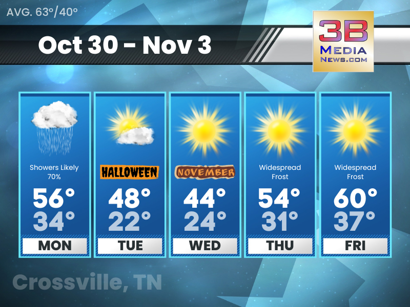
Monday’s 5-Day Forecast
Light rain is possible on Monday. Significantly colder temperatures arrive on Tuesday. Monday: Showers likely, mainly after 7am. Cloudy, with a high near 56. North northwest wind around 10 mph, with ...