

SUNNY SKIES AND RISING TEMPERATURES AHEAD!
Dry weather will take hold through Thursday afternoon. Uncomfortable afternoon humidity values will creep back into our area also factoring into our personal calculation of what you consider to be com ...

WEEK AHEAD: SUNNY DAYS WITH CHANCES OF SHOWERS AND THUNDERSTORMS
Heat index values of 100-105 are expected in the southern Tennessee Valley this afternoon. Monday: A 30 percent chance of showers and thunderstorms after 1pm. Patchy fog before 7am. Otherwise, most ...

SUNNY AND WARM WEEKEND, STORMS EXPECTED EARLY NEXT WEEK
First half of next week looks fairly active, so confidence is a little higher for better afternoon thunderstorm coverage each day. Saturday: Mostly sunny, with a high near 86. Calm wind becoming nort ...

INDEPENDENCE DAY WEATHER: SUNNY WITH EVENING SHOWERS POSSIBLE
New event. Heat Advisory from 7/4/2024 2:00 PM to 8:00 PM EDT for Blount County, TN, Rhea County, TN, Meigs County, TN, Monroe County, TN, Roane County, TN, Loudon County, TN, McMinn County, TN. Click ...

SUNNY START TO THE WEEK, INDEPENDENCE DAY SHOWERS LIKELY
Today will feel quite un-July-like thanks to cooler and drier air. Monday: Sunny, with a high near 81. North northeast wind 5 to 10 mph. Monday Night: Mostly clear, with a low around 60. Northeast ...

WEEKEND WEATHER: SHOWERS AND THUNDERSTORMS LIKELY, CLEARING UP BY MONDAY
Scattered showers and thunderstorms through the weekend. Isolated high rainfall totals possible. Saturday: A 40 percent chance of showers and thunderstorms, mainly after 10am. Partly sunny, with a ...

SUNNY SKIES WITH A CHANCE OF SHOWERS AND THUNDERSTORMS
Rain chances arrive on Wednesday through Wednesday night with a weak frontal passage. Another front may bring showers and storms by the weekend. Tuesday: Patchy fog before 7am. Otherwise, sunny, with ...

SUNNY SATURDAY, SLIGHT CHANCE OF STORMS SUNDAY
Sunny days with highs around 89-92°F and calm winds, occasional chances of showers and thunderstorms in the afternoons and evenings, and nighttime lows around 66-68°F from Saturday through Wednesday. ...

SUNNY AND WARM TEMPS, CHANCE OF SHOWERS BY SUNDAY NIGHT
Above average temperatures continue with strong ridging in place. Friday: Mostly sunny, with a high near 88. Calm wind. Friday Night: Mostly clear, with a low around 67. Calm wind. Saturday: Su ...

WARM WEEKEND AHEAD: HIGHS IN THE 90S, FULL STRAWBERRY MOON FRIDAY NIGHT
The first days of summer will bring sunny skies and warm temperatures, with highs reaching near 90°F and calm winds. A Full Strawberry Moon will grace the skies on Friday night. The weekend will be mo ...
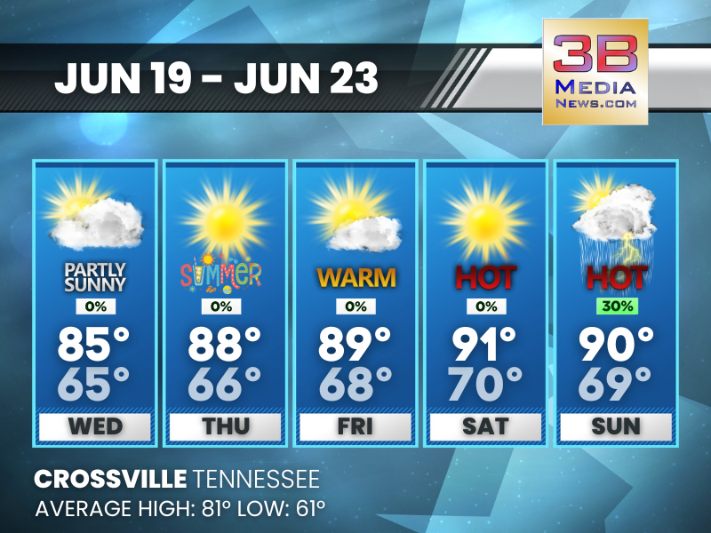
GETTING HOTTER THIS WEEKEND, SHOWERS POSSIBLE ON SUNDAY
Hot and dry conditions continue with strong ridging in place. Wednesday: Partly sunny, with a high near 85. Calm wind becoming south southeast around 5 mph. Wednesday Night: Partly cloudy, with a ...

SUNNY DAYS WITH SCATTERED SHOWERS AND THUNDERSTORMS EARLY IN THE WEEK
Very warm again Monday with another chance of afternoon and early evening storms. Monday: A 30 percent chance of showers and thunderstorms, mainly after 3pm. Mostly sunny, with a high near 88. South ...