
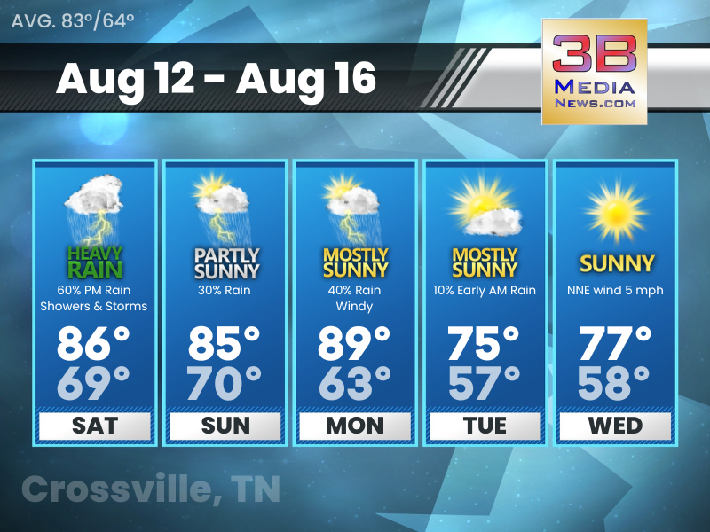
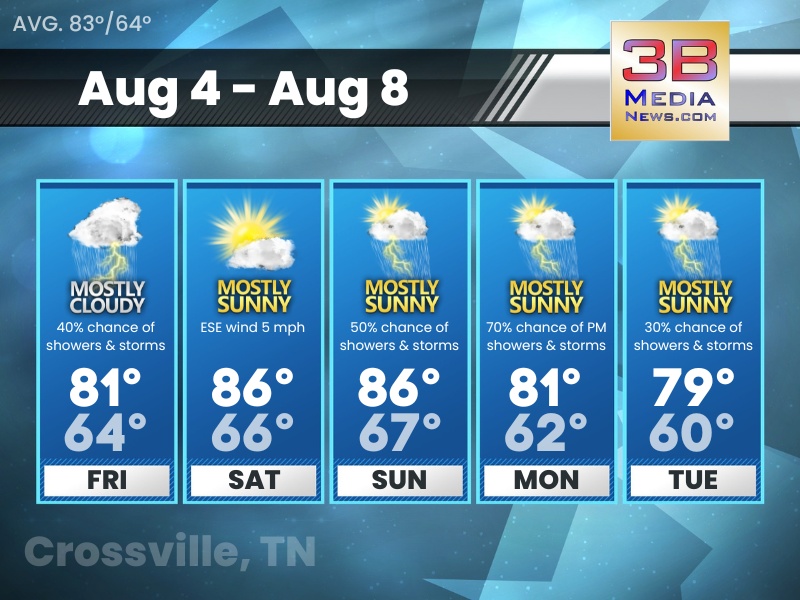
Saturday’s 5 Day Forecast
Hazardous Weather Outlook: An active period is expected this afternoon and evening with damaging winds the main threat and hail also possible. Heat index values are expected to be around 100 to 105 in ...

Friday’s 5 Day Forecast
Friday: A 20 percent chance of showers and thunderstorms. Patchy fog before 7am. Otherwise, mostly cloudy, then gradually becoming sunny, with a high near 82. Calm wind becoming west around 5 mph in t ...
Thursday’s 5 Day Forecast
Thursday: Showers and thunderstorms, mainly before 3pm. High near 76. West southwest wind 10 to 15 mph, with gusts as high as 25 mph. Chance of precipitation is 90%. New rainfall amounts between a hal ...
Wednesday’s 5 Day Forecast
Wednesday: A 40 percent chance of showers and thunderstorms, mainly after 3pm. Mostly sunny, with a high near 81. Calm wind becoming southwest around 5 mph in the morning. Wednesday Night: Showers an ...
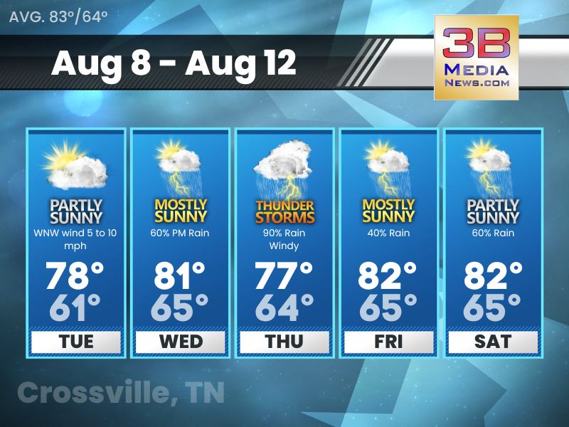
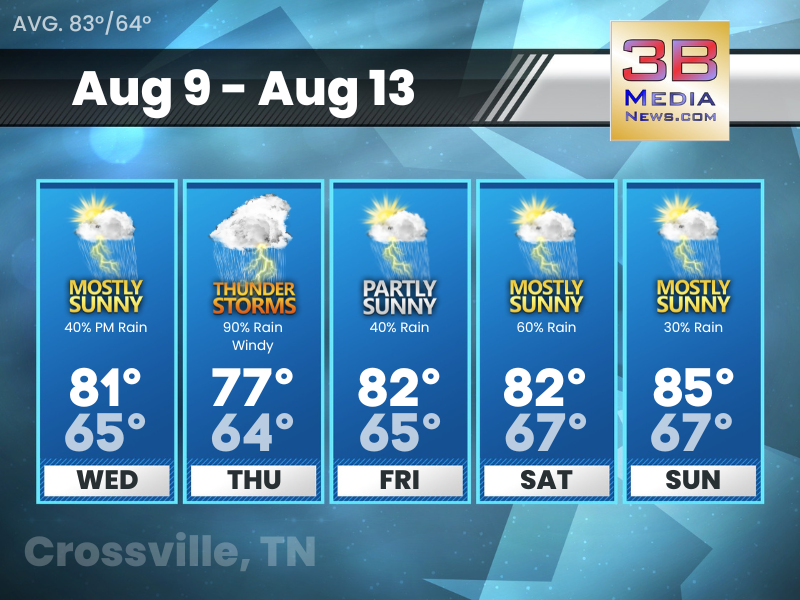
Tuesday’s 5 Day Forecast
Tuesday: Partly sunny, with a high near 78. West northwest wind 5 to 10 mph. Tuesday Night: Partly cloudy, with a low around 61. West wind around 5 mph becoming calm in the evening. Wednesday: Showe ...

Severe Thunderstorm Warning
Severe Thunderstorm Warning including Fairfield Glade TN, Monterey TN and Grimsley TN until 1:15 PM CDT. This storm will contain wind gusts to 70 MPH!

Severe Thunderstorm Warning
New event. Severe Thunderstorm Warning from 8/7/2023 12:26 PM to 1:00 PM CDT for Cumberland County, TN, Van Buren County, TN, White County, TN. This storm will contain wind gusts to 70 mph! Click here ...
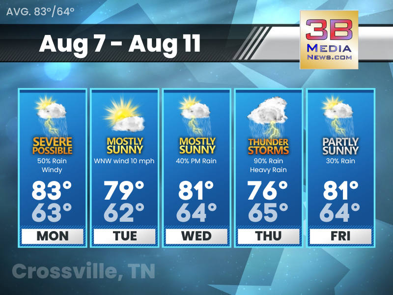
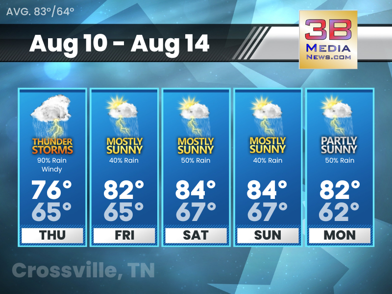
Monday’s 5 Day Forecast
Hazardous Weather Outlook: Thunderstorms can be expected Monday, and some of these storms will likely become strong to severe especially Monday afternoon into Monday evening. Primary risks on Monday w ...
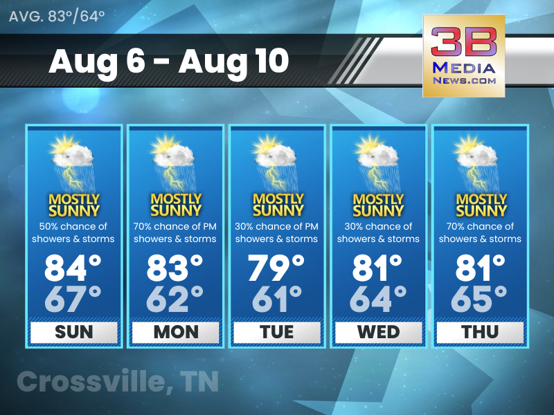
Sunday’s 5 Day Forecast
Hazardous Weather Outlook: Showers and thunderstorms can be expected Sunday into Monday. A few storms may become strong to severe, with the primary threats being damaging winds, hail, and torrential d ...

Dense Fog Advisory
The National Weather Service has issued a Dense Fog Advisory for portions of Middle Tennessee and South-Central Kentucky until 8 AM CDT / 9 AM EDT this morning. This includes Clay County, Clinton Coun ...

Saturday’s 5 Day Forecast
Hazardous Weather Outlook: Showers and thunderstorms can be expected Sunday into Monday. A few storms may become strong to severe, with the primary threats being damaging winds, hail, and torrential d ...
Friday’s 5 Day Forecast
Friday: A slight chance of showers and thunderstorms before 8am, then a slight chance of showers between 8am and 11am, then a chance of showers and thunderstorms after 11am. Mostly cloudy, with a high ...