
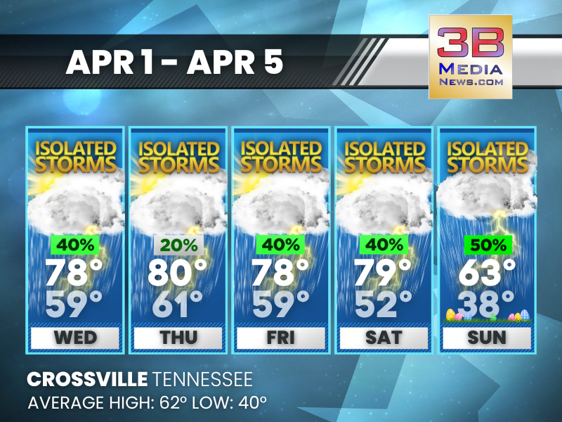
WET WEEK AHEAD WITH DAILY STORM CHANCES
Scattered storms persist daily, with a cooler turn by Easter Sunday. Wednesday: A 40 percent chance of showers and thunderstorms, mainly after 1pm. Partly sunny, with a high near 78. South southwes ...
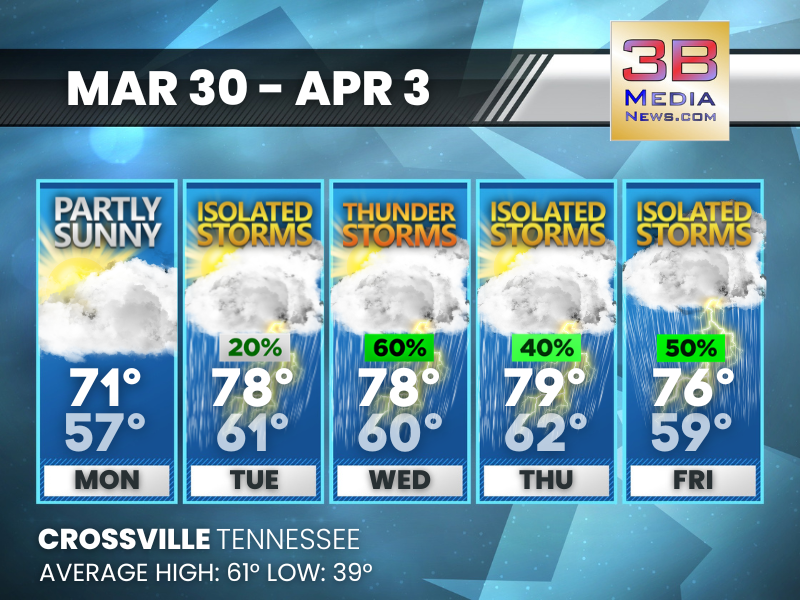
WARM TEMPS WITH REPEATED STORM CHANCES THROUGH THE WEEK
Temperatures trend well above average while scattered storm chances return on multiple days. Today: Partly sunny, with a high near 77. South southwest wind 5 to 10 mph, with gusts as high as 25 mph ...
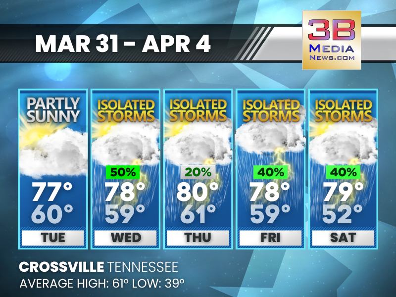
WARM WEEK WITH BUILDING STORM CHANCES MIDWEEK
A mild stretch brings increasing rain and thunderstorm chances through midweek, with the highest coverage on Wednesday before easing slightly toward the end of the week. Monday: Partly sunny, with ...
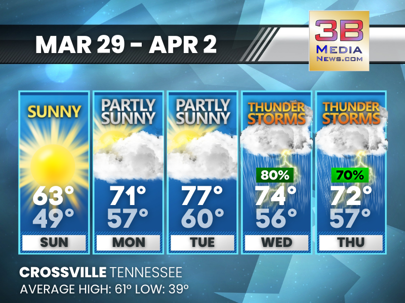
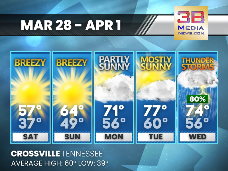
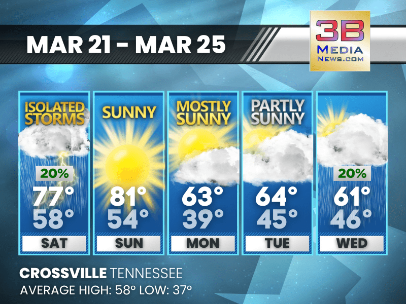
SPRING WARMTH BUILDS BEFORE MIDWEEK STORM CHANCES
Temperatures trend warmer through Tuesday before thunderstorms return Wednesday and Thursday. Sunday: Sunny, with a high near 63. South wind around 10 mph, with gusts as high as 25 mph. Sunday N ...
WARMING TREND WITH MIDWEEK STORMS
Temperatures climb steadily into the 70s before storms arrive midweek. Saturday: Sunny, with a high near 57. Northeast wind 10 to 15 mph, with gusts as high as 25 mph. Saturday Night: Clear, wit ...
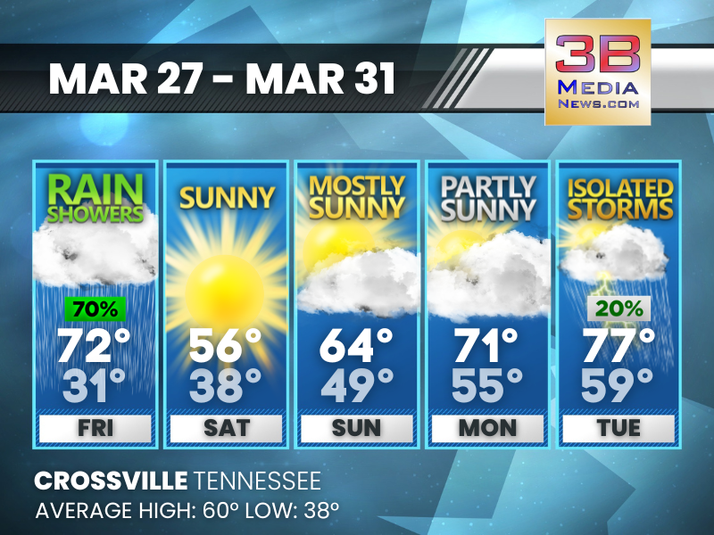
WET FRIDAY GIVES WAY TO WARMING TREND AND STORM CHANCES
Rain tapers off after Friday as sunshine returns for the weekend, followed by a steady warmup and a chance of storms by Tuesday. Friday: Showers likely after 1pm. Increasing clouds, with a high nea ...
WARM START, SHARP COOL DOWN, THEN REBOUND
Temperatures swing from mild to chilly before recovering into a more seasonable pattern with improving conditions. Today: Mostly sunny, with a high near 77. Southwest wind 5 to 15 mph, with gusts a ...
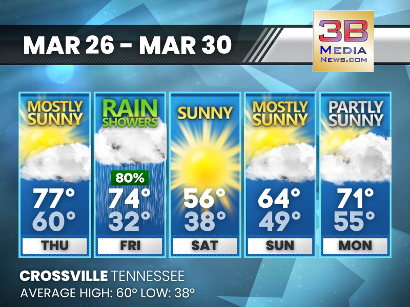
WARMING TREND PEAKS BEFORE RAINY FRIDAY COOL DOWN
Temperatures climb into the upper 70s by Thursday before a 70% rain chance Friday ushers in a cooler, sunny weekend. Wednesday: Partly sunny, with a high near 69. South wind 5 to 10 mph, with gusts ...
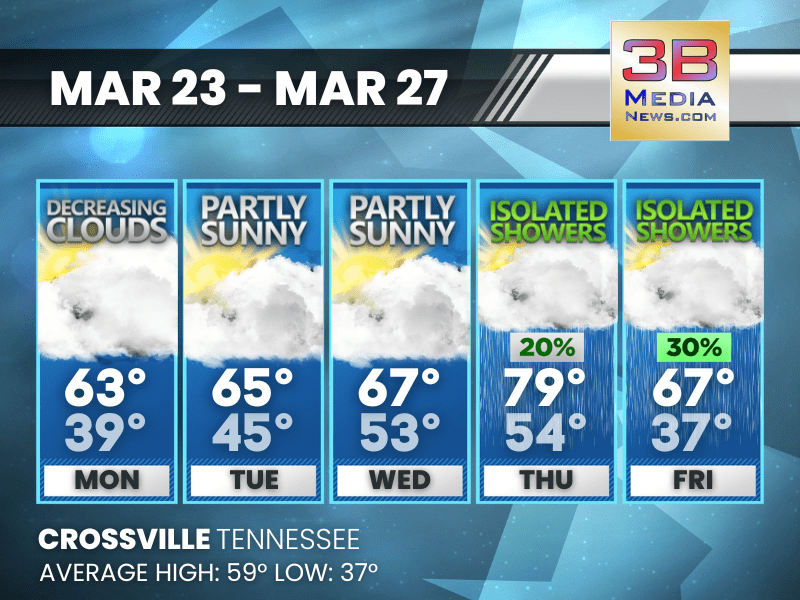
SPRING WARMTH SPIKES BEFORE A SHARP COOL-DOWN
Temperatures climb well above average through Thursday before a rain chance Friday and a noticeably cooler Saturday. Tuesday: Mostly cloudy through mid morning, then gradual clearing, with a high n ...
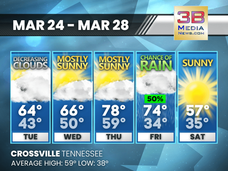
MIDWEEK MILD SPELL BEFORE SHOWERS RETURN
Temperatures trend milder through midweek with some sunshine before isolated showers develop late in the week. Monday: Cloudy through mid morning, then gradual clearing, with a high near 63. North ...
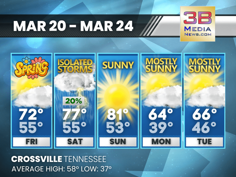
SPRING SWING: STORMS GIVE WAY TO SUN, THEN COOL DOWN
A brief round of storms is followed by a warm, sunny weekend before temperatures trend cooler with partly sunny skies midweek. Saturday: A 20 percent chance of showers and thunderstorms after 3pm. ...
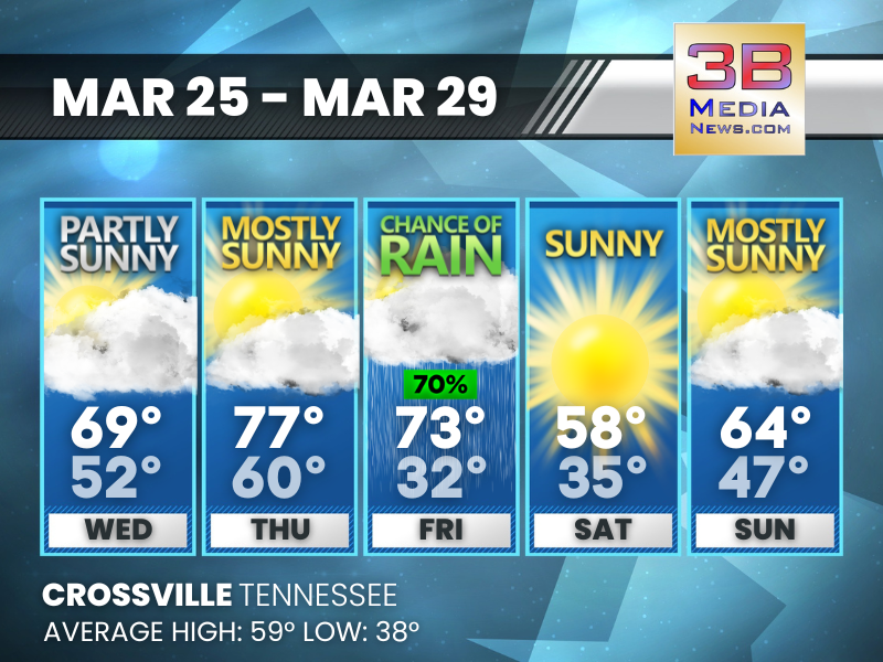
SPRING WARMTH HOLDS WITH MINIMAL WEEKEND RAIN
Temperatures climb into the weekend with only a slight chance of brief, isolated showers before cooler, mostly sunny conditions return early next week. Friday: Mostly sunny, with a high near 72. So ...